
Seller's Agent in 2026
Holly Richards
A New Day Realty, LLC
(252) 425-7895
7 Total Sales
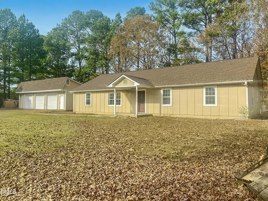


Discover the perfect blend of comfort, privacy, and wide-open space on this beautiful 33.68-acre property featuring a well-maintained 3-bedroom, 2-bath home, a 3-car detached garage, and barn—ideal for animal enthusiasts or anyone seeking room to roam. Step inside the inviting home where natural light fills the spacious living areas, complemented by a functional open layout designed for everyday living. The kitchen offers ample custom cabinet space and flows effortlessly into the dining and living rooms, making it easy to entertain. The primary suite features its own private bath, while two additional bedrooms provide flexibility for family, guests, or a home office. Outside, the possibilities are endless. Enjoy the convenience of a detached 2-car garage, perfect for vehicles, equipment, or a workshop setup. The beautiful barn is ready for your horses, cows or can be repurposed for storage or hobbies. With over 33 acres, you'll find plenty of space for riding, farming, gardening, or simply soaking in the peaceful country setting. Whether you're dreaming of a hobby farm, a private retreat, or an active rural lifestyle, this property offers an exceptional opportunity to create the life you've always wanted.
Last Agent to Sell the Property
A New Day Realty, LLC License #360240 Listed on: 11/19/2025
| Date | Type | Sale Price | Title Company |
|---|---|---|---|
| Warranty Deed | $793,000 | None Listed On Document | |
| Interfamily Deed Transfer | -- | None Available | |
| Warranty Deed | $140,000 | None Available | |
| Interfamily Deed Transfer | -- | None Available | |
| Warranty Deed | $175,000 | None Available |
| Date | Status | Loan Amount | Loan Type |
|---|---|---|---|
| Open | $654,900 | VA | |
| Previous Owner | $138,139 | FHA |
| Date | Event | Price | List to Sale | Price per Sq Ft |
|---|---|---|---|---|
| 01/29/2026 01/29/26 | Sold | $750,000 | -5.7% | $387 / Sq Ft |
| 12/13/2025 12/13/25 | Pending | -- | -- | -- |
| 11/19/2025 11/19/25 | For Sale | $795,000 | -- | $410 / Sq Ft |
| Year | Tax Paid | Tax Assessment Tax Assessment Total Assessment is a certain percentage of the fair market value that is determined by local assessors to be the total taxable value of land and additions on the property. | Land | Improvement |
|---|---|---|---|---|
| 2025 | $1,458 | $231,660 | $41,440 | $190,220 |
| 2024 | $1,458 | $231,660 | $41,440 | $190,220 |
| 2023 | $1,353 | $141,623 | $14,683 | $126,940 |
| 2022 | $1,343 | $141,623 | $14,683 | $126,940 |
| 2021 | $1,358 | $141,623 | $14,683 | $126,940 |
| 2020 | $1,367 | $141,623 | $14,683 | $126,940 |
| 2019 | $1,341 | $141,623 | $14,683 | $126,940 |
| 2018 | $1,336 | $141,623 | $14,683 | $126,940 |
| 2017 | $1,280 | $124,995 | $13,355 | $111,640 |
| 2016 | $1,324 | $124,995 | $13,355 | $111,640 |
| 2015 | $1,324 | $124,995 | $13,355 | $111,640 |
| 2014 | -- | $124,995 | $13,355 | $111,640 |
Seller's Agent in 2026
Holly Richards
A New Day Realty, LLC
(252) 425-7895
7 Total Sales
R
Buyer's Agent in 2026
Ronald Ricks
United Real Estate Triangle
(252) 266-9447
24 Total Sales
Source: Doorify MLS
MLS Number: 10133899
APN: 010840
Disclaimer: Certain information contained herein is derived from information provided by parties other than Homes.com. All information provided is deemed reliable, but is not guaranteed to be accurate and should be independently verified.
![]() Some IDX listings have been excluded from this IDX display. Brokers make an effort to deliver accurate information, but buyers should independently verify any information on which they will rely in a transaction. The listing broker shall not be responsible for any typographical errors, misinformation, or misprints, and they shall be held totally harmless from any damages arising from reliance upon this data. This data is provided exclusively for consumers’ personal, non-commercial use. Listings marked with an icon are provided courtesy of the Doorify MLS, Inc. of North Carolina, Internet Data Exchange Database. Closed (sold) listings may have been listed and/or sold by a real estate firm other than the firm(s) featured on this website. Closed data is not available until the sale of the property is recorded in the MLS. Home sale data is not an appraisal, CMA, competitive or comparative market analysis, or home valuation of any property. Copyright 2026 Doorify MLS, Inc. of North Carolina. All rights reserved.
Some IDX listings have been excluded from this IDX display. Brokers make an effort to deliver accurate information, but buyers should independently verify any information on which they will rely in a transaction. The listing broker shall not be responsible for any typographical errors, misinformation, or misprints, and they shall be held totally harmless from any damages arising from reliance upon this data. This data is provided exclusively for consumers’ personal, non-commercial use. Listings marked with an icon are provided courtesy of the Doorify MLS, Inc. of North Carolina, Internet Data Exchange Database. Closed (sold) listings may have been listed and/or sold by a real estate firm other than the firm(s) featured on this website. Closed data is not available until the sale of the property is recorded in the MLS. Home sale data is not an appraisal, CMA, competitive or comparative market analysis, or home valuation of any property. Copyright 2026 Doorify MLS, Inc. of North Carolina. All rights reserved.
Ask me questions while you tour the home.