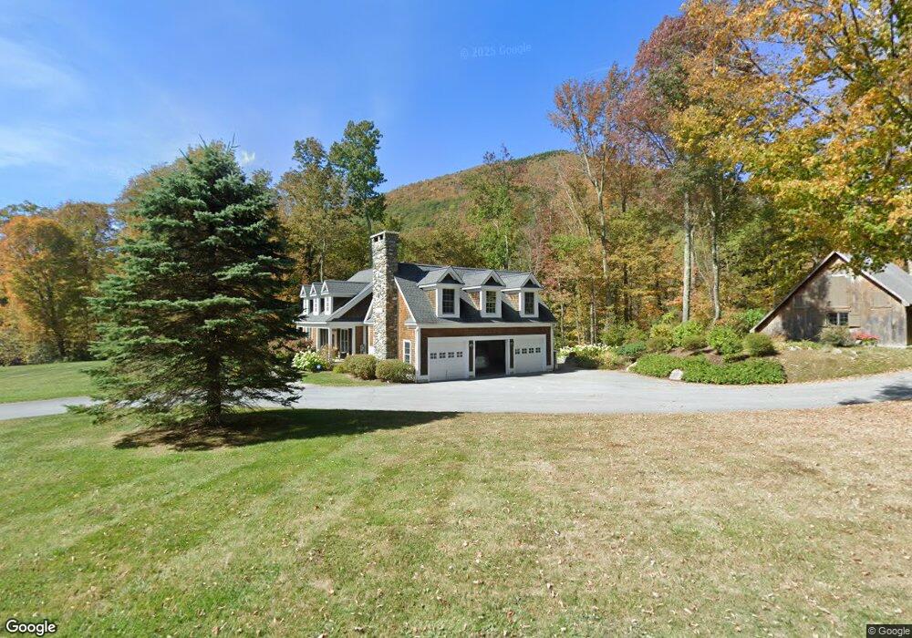
319 Tower Rd Dorset, VT 05251
Estimated Value: $773,000 - $2,091,384
Studio
--
Bath
--
Sq Ft
2.93
Acres Lot
About This Home
This home is located at 319 Tower Rd, Dorset, VT 05251 and is currently estimated at $1,574,128. 319 Tower Rd is a home located in Bennington County with nearby schools including The Dorset School and Long Trail School.
Ownership History
Date
Name
Owned For
Owner Type
Purchase Details
Closed on
Sep 9, 2022
Sold by
Rosenberg Allyson and Rosenberg Richard A
Bought by
Mcgillivray Duncan N and Prophett Laureen A
Current Estimated Value
Purchase Details
Closed on
Jun 25, 2013
Sold by
Rosenberg Richard A and Rosenberg Allyson
Bought by
Rosenberg Allyson
Purchase Details
Closed on
May 31, 2012
Sold by
Mauro Charles D
Bought by
Rosenberg Richard A and Rosenberg Allyson
Purchase Details
Closed on
Aug 17, 2001
Sold by
Radicioni Mark A and Radicioni Diedre L
Bought by
Mauro Charles D
Create a Home Valuation Report for This Property
The Home Valuation Report is an in-depth analysis detailing your home's value as well as a comparison with similar homes in the area
Home Values in the Area
Average Home Value in this Area
Purchase History
| Date | Buyer | Sale Price | Title Company |
|---|---|---|---|
| Mcgillivray Duncan N | $1,925,000 | -- | |
| Rosenberg Allyson | -- | -- | |
| Rosenberg Richard A | $910,000 | -- | |
| Mauro Charles D | $80,000 | -- | |
| Mauro Charles D | $80,000 | -- |
Source: Public Records
Tax History
| Year | Tax Paid | Tax Assessment Tax Assessment Total Assessment is a certain percentage of the fair market value that is determined by local assessors to be the total taxable value of land and additions on the property. | Land | Improvement |
|---|---|---|---|---|
| 2024 | -- | $884,230 | $259,300 | $624,930 |
| 2023 | -- | $884,230 | $259,300 | $624,930 |
| 2022 | $17,105 | $880,960 | $259,300 | $621,660 |
| 2021 | $16,085 | $851,480 | $259,300 | $592,180 |
| 2020 | $15,829 | $851,480 | $259,300 | $592,180 |
| 2019 | $14,987 | $851,480 | $259,300 | $592,180 |
| 2018 | $14,898 | $851,480 | $259,300 | $592,180 |
| 2017 | $0 | $851,480 | $259,300 | $592,180 |
| 2016 | $14,481 | $851,500 | $259,300 | $592,180 |
| 2015 | -- | $8,515 | $0 | $0 |
| 2014 | -- | $8,515 | $0 | $0 |
| 2013 | -- | $8,515 | $0 | $0 |
Source: Public Records
Map
Nearby Homes
- 50 Grouse Ln
- 1060 Upper Hollow Rd
- lot A Forest Pond Rd
- 2744 Danby Mountain Rd
- 3191 Vermont 30
- 215 Vermont 30
- 0 Havoc Hill Unit 29
- 2677 Route 30
- 3622 Dorset West Rd
- 120 Village St
- 27 Owls Head Hill Ln
- 0 Rocky Ln Unit 5082777
- 191 Pleasant Street Extension
- 2937 Dorset Rd W
- 23 Stonewall Ln
- 500 Nims Rd
- 201 Owls Head Hill Ln
- 393 Morse Hill Rd
- 2334 Morse Hill Rd
- lot B Frost Pond Rd
- 319 Tower Rd
- 319 Tower Rd
- TBD Tower Rd
- 87 Pasture Ln
- 87 Pasture Ln
- 46 Grouse Ln
- 188 Pasture Ln
- 314 Tower Rd
- 189 Pasture Ln
- 48 Grouse Ln
- 541 Tower Rd
- 573 Tower Rd
- 2173 Upper Hollow Rd
- 2491 Lower Hollow Rd
- 194 Grouse Ln
- 190 Turkey Run
- 580 Tower Rd
- 190 Turkey Run Ln
- 2430 Lower Hollow Rd
- 2028 Lower Hollow Rd
Your Personal Tour Guide
Ask me questions while you tour the home.