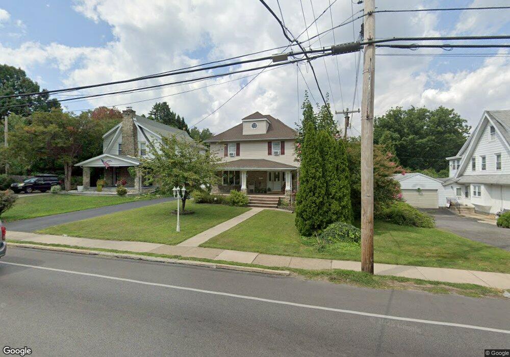
319 W Springfield Rd Springfield, PA 19064
Estimated Value: $461,000 - $531,000
3
Beds
3
Baths
2,135
Sq Ft
$234/Sq Ft
Est. Value
About This Home
This home is located at 319 W Springfield Rd, Springfield, PA 19064 and is currently estimated at $500,144, approximately $234 per square foot. 319 W Springfield Rd is a home located in Delaware County with nearby schools including Springfield High School, St Francis Of Assisi School, and Holy Cross School.
Ownership History
Date
Name
Owned For
Owner Type
Purchase Details
Closed on
Jun 27, 2003
Sold by
Gifford Michael D and Gifford Barbara A
Bought by
Smith Joseph A and Smith Lisa M
Current Estimated Value
Home Financials for this Owner
Home Financials are based on the most recent Mortgage that was taken out on this home.
Original Mortgage
$236,750
Outstanding Balance
$101,261
Interest Rate
5.34%
Mortgage Type
VA
Estimated Equity
$398,883
Create a Home Valuation Report for This Property
The Home Valuation Report is an in-depth analysis detailing your home's value as well as a comparison with similar homes in the area
Home Values in the Area
Average Home Value in this Area
Purchase History
| Date | Buyer | Sale Price | Title Company |
|---|---|---|---|
| Smith Joseph A | $229,900 | -- |
Source: Public Records
Mortgage History
| Date | Status | Borrower | Loan Amount |
|---|---|---|---|
| Open | Smith Joseph A | $236,750 |
Source: Public Records
Tax History
| Year | Tax Paid | Tax Assessment Tax Assessment Total Assessment is a certain percentage of the fair market value that is determined by local assessors to be the total taxable value of land and additions on the property. | Land | Improvement |
|---|---|---|---|---|
| 2025 | $7,615 | $270,920 | $96,380 | $174,540 |
| 2024 | $7,615 | $270,920 | $96,380 | $174,540 |
| 2023 | $7,332 | $270,920 | $96,380 | $174,540 |
| 2022 | $7,174 | $270,920 | $96,380 | $174,540 |
| 2021 | $11,110 | $270,920 | $96,380 | $174,540 |
| 2020 | $5,679 | $125,330 | $46,340 | $78,990 |
| 2019 | $5,546 | $125,330 | $46,340 | $78,990 |
| 2018 | $5,466 | $125,330 | $0 | $0 |
| 2017 | $5,340 | $125,330 | $0 | $0 |
| 2016 | $688 | $125,330 | $0 | $0 |
| 2015 | $688 | $125,330 | $0 | $0 |
| 2014 | $688 | $125,330 | $0 | $0 |
Source: Public Records
Map
Nearby Homes
- 412 Foster Dr
- 120 W Springfield Rd
- 29 School Ln
- 606 W Springfield Rd
- 225 Lynbrooke Rd
- 501 Flora Cir
- 226 Lynbrooke Rd
- 147 Snyder Ln
- 264 Pancoast Ave
- 364 S Rolling Rd
- 227 E Leamy Ave
- 412 N Rolling Rd
- 332 Franklin Ave
- 641 W Sproul Rd
- 720 Evans Rd
- 173 Rambling Way
- 249 Gleaves Rd
- 493 Wheatsheaf Rd
- 472 Larchwood Rd
- 463 Foulke Ln
- 327 W Springfield Rd
- 317 W Springfield Rd
- 311 W Springfield Rd
- 100 S Highland Rd
- 373 Summit Rd
- 316 W Springfield Rd
- 301 W Springfield Rd
- 308 W Springfield Rd
- 336 W Springfield Rd
- 369 Summit Rd
- 300 W Springfield Rd
- 116 S Highland Rd
- 101 S Highland Rd
- 112 S Highland Rd
- 4 Saxer Ave
- 1 Forest Rd
- 8 Saxer Ave
- 120 S Highland Rd
- 15 Lownes Ln
- 400 Foster Dr
Your Personal Tour Guide
Ask me questions while you tour the home.