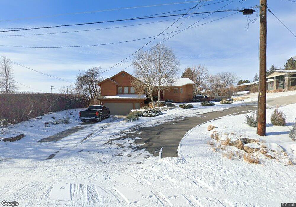
3190 W Macdonald Dr Billings, MT 59102
North Central Billings NeighborhoodEstimated Value: $552,175 - $631,000
4
Beds
3
Baths
3,416
Sq Ft
$171/Sq Ft
Est. Value
About This Home
This home is located at 3190 W Macdonald Dr, Billings, MT 59102 and is currently estimated at $585,294, approximately $171 per square foot. 3190 W Macdonald Dr is a home located in Yellowstone County with nearby schools including Poly Drive School, Will James Junior High School, and Billings Senior High School.
Ownership History
Date
Name
Owned For
Owner Type
Purchase Details
Closed on
Jun 14, 2021
Sold by
Ludvingson Ryan and Williams Jenny
Bought by
Paquin Scott and Paquin Melinda
Current Estimated Value
Home Financials for this Owner
Home Financials are based on the most recent Mortgage that was taken out on this home.
Original Mortgage
$436,932
Outstanding Balance
$395,587
Interest Rate
2.9%
Mortgage Type
VA
Estimated Equity
$189,707
Purchase Details
Closed on
Oct 7, 2019
Sold by
Steinmetz Kenneth A and Steinmetz Terri L
Bought by
Ludvigson Ryan and Williamson Jenny
Create a Home Valuation Report for This Property
The Home Valuation Report is an in-depth analysis detailing your home's value as well as a comparison with similar homes in the area
Home Values in the Area
Average Home Value in this Area
Purchase History
| Date | Buyer | Sale Price | Title Company |
|---|---|---|---|
| Paquin Scott | -- | First Montana Title Co | |
| Ludvigson Ryan | -- | First American Title |
Source: Public Records
Mortgage History
| Date | Status | Borrower | Loan Amount |
|---|---|---|---|
| Open | Paquin Scott | $436,932 |
Source: Public Records
Tax History
| Year | Tax Paid | Tax Assessment Tax Assessment Total Assessment is a certain percentage of the fair market value that is determined by local assessors to be the total taxable value of land and additions on the property. | Land | Improvement |
|---|---|---|---|---|
| 2025 | $4,435 | $584,000 | $59,239 | $524,761 |
| 2024 | $4,435 | $465,600 | $56,218 | $409,382 |
| 2023 | $4,869 | $465,600 | $56,218 | $409,382 |
| 2022 | $3,918 | $415,000 | $0 | $0 |
| 2021 | $4,586 | $404,700 | $0 | $0 |
| 2020 | $4,336 | $363,000 | $0 | $0 |
| 2019 | $3,957 | $342,400 | $0 | $0 |
| 2018 | $4,039 | $344,900 | $0 | $0 |
| 2017 | $3,193 | $344,900 | $0 | $0 |
| 2016 | $3,625 | $316,900 | $0 | $0 |
| 2015 | $3,554 | $316,900 | $0 | $0 |
| 2014 | $3,399 | $160,272 | $0 | $0 |
Source: Public Records
Map
Nearby Homes
- 2644 Rimrock Rd
- 2646 Rimrock Rd
- 3332 Rockwood Cir
- 2756 Gregory Dr N
- 2815 Palm Dr
- 2721 Louise Ln
- 2504 Rancho Rd
- 3441 Masterson Cir
- 3065 Gregory Dr W
- 2713 Downer Ln
- 2306 Fairway Dr
- 3311 Harlou Dr
- 3210 Durland Dr
- 2804 Poly Dr
- 2413 Elizabeth St
- 3012 Leeann Blvd
- 2308 Louise Ln
- 3201 Leeann Blvd
- 2618 Sunnyview Ln
- 2117 Fairway Dr
- 3120 W Macdonald Dr
- 3119 Gregory Dr
- 3131 Gregory Dr
- 3204 W Macdonald Dr
- 3212 E Macdonald Dr
- 3210 W Macdonald Dr
- 3130 Gregory Dr
- 3139 Gregory Dr
- 3120 Gregory Dr
- 3105 Gregory Dr
- 3100 W Macdonald Dr
- 3112 Gregory Dr
- 2711 Gregory Dr N
- 3206 E Macdonald Dr
- 3217 E Macdonald Dr
- 2706 Gregory Dr N
- 3104 Gregory Dr
- 3022 W Macdonald Dr
- 3015 Gregory Dr
- 3215 E Macdonald Dr
Your Personal Tour Guide
Ask me questions while you tour the home.