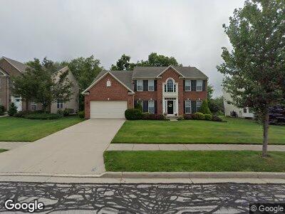
3191 Evans Way Twinsburg, OH 44087
Estimated Value: $559,961 - $616,000
4
Beds
4
Baths
3,353
Sq Ft
$176/Sq Ft
Est. Value
About This Home
This home is located at 3191 Evans Way, Twinsburg, OH 44087 and is currently estimated at $589,490, approximately $175 per square foot. 3191 Evans Way is a home located in Summit County with nearby schools including Wilcox Primary School, Dodge Intermediate School, and Samuel Bissell Elementary School.
Ownership History
Date
Name
Owned For
Owner Type
Purchase Details
Closed on
Aug 22, 2008
Sold by
Nvr Inc
Bought by
Deshpande Anirudha R and Sathe Pranjali D
Current Estimated Value
Home Financials for this Owner
Home Financials are based on the most recent Mortgage that was taken out on this home.
Original Mortgage
$273,100
Interest Rate
6.57%
Mortgage Type
Purchase Money Mortgage
Purchase Details
Closed on
Jun 2, 2008
Sold by
Twinsburg Four Llc
Bought by
Nvr Inc and Ryan Homes
Create a Home Valuation Report for This Property
The Home Valuation Report is an in-depth analysis detailing your home's value as well as a comparison with similar homes in the area
Home Values in the Area
Average Home Value in this Area
Purchase History
| Date | Buyer | Sale Price | Title Company |
|---|---|---|---|
| Deshpande Anirudha R | $310,390 | Nvr Title | |
| Nvr Inc | $82,500 | Erie Title Agency Inc |
Source: Public Records
Mortgage History
| Date | Status | Borrower | Loan Amount |
|---|---|---|---|
| Open | Deshpande Anirudha | $233,000 | |
| Closed | Deshpande Anirudha R | $250,000 | |
| Closed | Deshpande Anirudha R | $273,100 |
Source: Public Records
Tax History Compared to Growth
Tax History
| Year | Tax Paid | Tax Assessment Tax Assessment Total Assessment is a certain percentage of the fair market value that is determined by local assessors to be the total taxable value of land and additions on the property. | Land | Improvement |
|---|---|---|---|---|
| 2025 | $9,340 | $164,088 | $26,534 | $137,554 |
| 2024 | $9,340 | $164,088 | $26,534 | $137,554 |
| 2023 | $9,340 | $164,088 | $26,534 | $137,554 |
| 2022 | $8,155 | $125,511 | $20,255 | $105,256 |
| 2021 | $8,201 | $125,511 | $20,255 | $105,256 |
| 2020 | $8,284 | $125,520 | $20,260 | $105,260 |
| 2019 | $7,297 | $102,780 | $20,260 | $82,520 |
| 2018 | $7,354 | $102,780 | $20,260 | $82,520 |
| 2017 | $6,339 | $102,780 | $20,260 | $82,520 |
| 2016 | $6,485 | $102,780 | $20,260 | $82,520 |
| 2015 | $6,339 | $102,780 | $20,260 | $82,520 |
| 2014 | $6,202 | $100,690 | $20,260 | $80,430 |
| 2013 | $6,286 | $101,990 | $20,260 | $81,730 |
Source: Public Records
Map
Nearby Homes
- Lot Parcel 6409683 Simecek Dr
- 3206 Darien Ln
- 2887 Abrams Dr
- 3066 Wyatts Way
- 3284 Cannon Rd
- 9768 Firelands Dr
- 2716 Walton Blvd
- 2809 Haggett Dr
- 2652 Post Rd
- 2700 Walton Blvd
- 3490 Shadow Ledge Dr
- 9666 Darrow Rd
- 10130 Flagstone Dr
- 2939 Alling Dr
- 3576 Jude Cir
- 3020 Irena Ln
- 3586 Jude Cir
- 3330 Shale Dr
- 2915 Alling Dr
- 3047 Liberty Ledges Dr