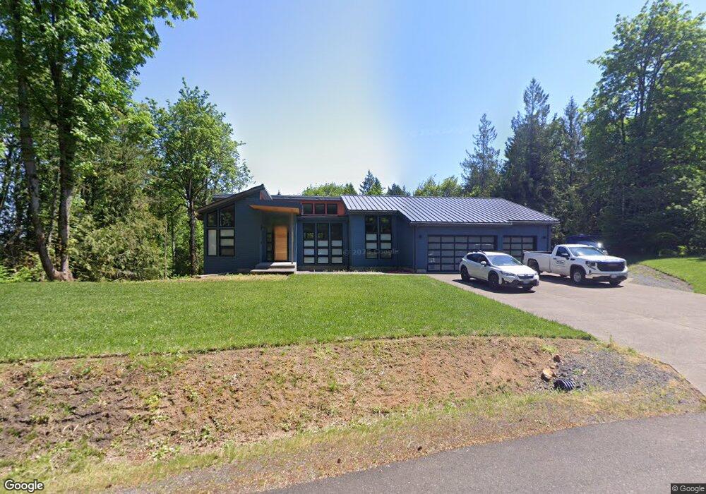
31910 Wayside Ct Scappoose, OR 97056
Estimated Value: $896,000 - $1,042,000
2
Beds
3
Baths
2,291
Sq Ft
$417/Sq Ft
Est. Value
About This Home
This home is located at 31910 Wayside Ct, Scappoose, OR 97056 and is currently estimated at $956,068, approximately $417 per square foot. 31910 Wayside Ct is a home with nearby schools including Scappoose High School.
Ownership History
Date
Name
Owned For
Owner Type
Purchase Details
Closed on
Feb 15, 2018
Sold by
Columbia Hills Land Company
Bought by
Ousley Christoper R and Ousley Marcy L
Current Estimated Value
Home Financials for this Owner
Home Financials are based on the most recent Mortgage that was taken out on this home.
Original Mortgage
$553,713
Outstanding Balance
$480,274
Interest Rate
4.75%
Mortgage Type
Construction
Estimated Equity
$475,794
Create a Home Valuation Report for This Property
The Home Valuation Report is an in-depth analysis detailing your home's value as well as a comparison with similar homes in the area
Home Values in the Area
Average Home Value in this Area
Purchase History
| Date | Buyer | Sale Price | Title Company |
|---|---|---|---|
| Ousley Christoper R | $169,900 | Ticor Title |
Source: Public Records
Mortgage History
| Date | Status | Borrower | Loan Amount |
|---|---|---|---|
| Open | Ousley Christoper R | $553,713 |
Source: Public Records
Tax History Compared to Growth
Tax History
| Year | Tax Paid | Tax Assessment Tax Assessment Total Assessment is a certain percentage of the fair market value that is determined by local assessors to be the total taxable value of land and additions on the property. | Land | Improvement |
|---|---|---|---|---|
| 2025 | $7,747 | $579,300 | $180,630 | $398,670 |
| 2024 | $7,525 | $562,430 | $175,370 | $387,060 |
| 2023 | $7,491 | $546,050 | $166,350 | $379,700 |
| 2022 | $7,155 | $530,150 | $161,500 | $368,650 |
| 2021 | $6,954 | $514,710 | $153,850 | $360,860 |
| 2020 | $5,333 | $416,770 | $157,240 | $259,530 |
| 2019 | $3,861 | $299,120 | $143,510 | $155,610 |
| 2018 | $1,049 | $99,490 | $99,490 | $0 |
| 2017 | $1,037 | $96,600 | $96,600 | $0 |
| 2016 | $1,061 | $93,790 | $93,790 | $0 |
| 2015 | $998 | $91,060 | $91,060 | $0 |
| 2014 | $1,046 | $98,610 | $98,610 | $0 |
Source: Public Records
Map
Nearby Homes
- 0 Hawthorne Unit 8 23537227
- 0 Hawthorne Unit 10 23372609
- 0 Hawthorne Unit 9 23026376
- 0 Hemlock Ave Unit 120247766
- 0 Callahan Unit 28 23508167
- 0 Callahan Unit 26 23220367
- 0 Callahan Unit 27
- 24 Callahan
- 4 Briarwood Dr Unit 4
- 50322 Briarwood Ct
- 21400 NW Watson Rd
- Hillsdale Plan at Dutch Canyon
- Aubrey Plan at Dutch Canyon
- Carmichael Plan at Dutch Canyon
- Carlton Plan at Dutch Canyon
- 33281 Kammeyer Rd
- 51557 SW Em Watts Rd
- 33362 SW Rokin Way
- 33366 SW Rokin Way
- 33340 SW Rokin Way
- 31886 Wayside Ct
- 31921 Wayside Ct
- 0 Wayside Ct Unit 9017547
- 0 Wayside Ct Unit 9017536
- 0 Wayside Ct Unit 9017522
- 0 Wayside Ct Unit 10004220
- 0 Wayside Ct Unit 10010004
- 0 Wayside Ct Unit Lot 6
- 6 Wayside Ct Unit 6
- 1 Wayside Ct Unit 1
- 2 Wayside Ct Unit 2
- 3 Wayside Ct
- 5 Wayside Ct Unit 5
- 50400 Maple Meadows Ave
- 4 Maple Meadows Unit 4
- 31954 Wayside Ct
- 1 Maple Meadows
- 0 Maple Meadows Unit Lot 6 19040573
- 0 Maple Meadows Unit 2 19593941
- 0 Maple Meadows Unit 3 19277791