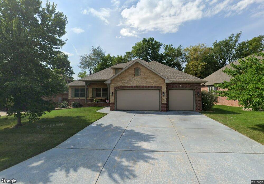
3198 W Brett Dr Springfield, MO 65810
Southwest Springfield NeighborhoodEstimated Value: $404,280 - $453,000
3
Beds
2
Baths
2,410
Sq Ft
$175/Sq Ft
Est. Value
About This Home
This home is located at 3198 W Brett Dr, Springfield, MO 65810 and is currently estimated at $421,820, approximately $175 per square foot. 3198 W Brett Dr is a home with nearby schools including McBride Elementary School, Wilson's Creek Intermediate School, and Cherokee Middle School.
Ownership History
Date
Name
Owned For
Owner Type
Purchase Details
Closed on
Mar 25, 2024
Sold by
Alberty Ronald W and Alberty Karen J
Bought by
Revocable Living Trust and Alberty
Current Estimated Value
Purchase Details
Closed on
Jul 26, 2012
Sold by
Rhc Stonebridge Llc
Bought by
Alberty Ronald W and Alberty Karen J
Create a Home Valuation Report for This Property
The Home Valuation Report is an in-depth analysis detailing your home's value as well as a comparison with similar homes in the area
Home Values in the Area
Average Home Value in this Area
Purchase History
| Date | Buyer | Sale Price | Title Company |
|---|---|---|---|
| Revocable Living Trust | -- | None Listed On Document | |
| Alberty Ronald W | -- | None Available | |
| Rhc Stonebridge Llc | -- | None Available |
Source: Public Records
Tax History
| Year | Tax Paid | Tax Assessment Tax Assessment Total Assessment is a certain percentage of the fair market value that is determined by local assessors to be the total taxable value of land and additions on the property. | Land | Improvement |
|---|---|---|---|---|
| 2025 | $2,995 | $62,170 | $7,130 | $55,040 |
| 2024 | $2,995 | $54,070 | $5,050 | $49,020 |
| 2023 | $2,979 | $54,070 | $5,050 | $49,020 |
| 2022 | $2,601 | $48,390 | $5,050 | $43,340 |
| 2021 | $2,600 | $48,390 | $5,050 | $43,340 |
| 2020 | $2,575 | $45,440 | $5,050 | $40,390 |
| 2019 | $2,501 | $45,440 | $5,050 | $40,390 |
| 2018 | $2,499 | $45,290 | $5,050 | $40,240 |
| 2017 | $2,474 | $43,700 | $5,050 | $38,650 |
| 2016 | $2,388 | $43,700 | $5,050 | $38,650 |
| 2015 | $2,369 | $43,700 | $5,050 | $38,650 |
| 2014 | $2,327 | $11,430 | $5,050 | $6,380 |
Source: Public Records
Map
Nearby Homes
- 5663 S Farm Road 135
- 3206 W Grayrock Dr
- 3216 W Ellison Dr
- 3060 W Ellison Dr
- 5321 S James Ave
- 3045 W Darby St
- 5786 S Brightwater Trail
- 2829 W Ellison Dr
- 2992 W Nottingham St
- 5909 S Brightwater Trail
- 3094 W Cedarbluff Dr
- 5150 S Tujunga Dr
- 6046 S Parkhaven Ln
- 2992 W Cedarbluff Dr
- 5094 S Burrows Ave
- 5628 S Winsor Dr
- 5644 S Winsor Dr
- 3551 W Cole St
- 2801 W Oxbow Ln
- 3481 W Moark St
- 3210 W Brett Dr
- 3186 W Brett Dr
- 3222 W Brett Dr
- 3197 W Brett Dr
- 3185 W Brett Dr
- 3234 W Brett Dr
- 3221 W Brett Dr
- 3246 W Brett Dr
- 3233 W Brett Dr
- 3196 W High Point St
- 3157 W Blossom Dr
- 3209 W Blossom Dr
- 3184 W High Point St
- 3196 W Highpoint St
- 3172 W High Point St Unit L44
- 3220 W Highpoint St
- 3245 W Brett Dr
- 3220 W High Point St
- 3258 W Brett Dr
- 3232 W High Point St
Your Personal Tour Guide
Ask me questions while you tour the home.