

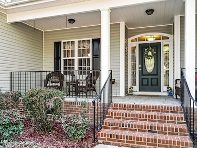
32 Bridgeport Cir Clayton, NC 27527
Estimated payment $3,000/month
Total Views
3,298
4
Beds
2.5
Baths
2,488
Sq Ft
$205
Price per Sq Ft
Highlights
- Hot Property
- Partially Wooded Lot
- Wood Flooring
- Riverwood Elementary School Rated A-
- Traditional Architecture
- Main Floor Bedroom
About This Home
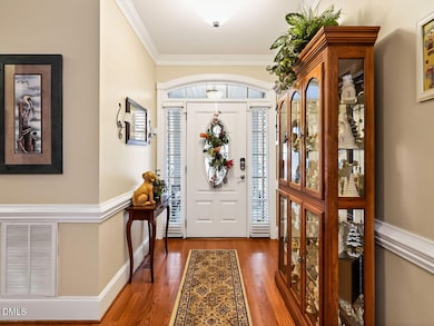
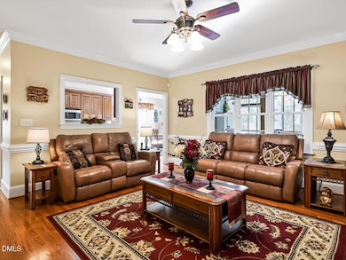
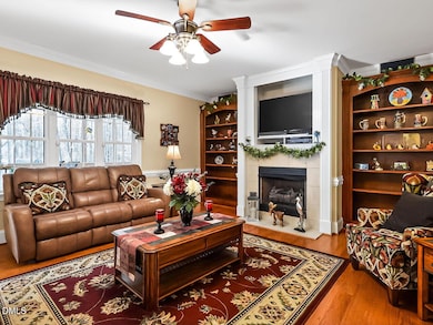
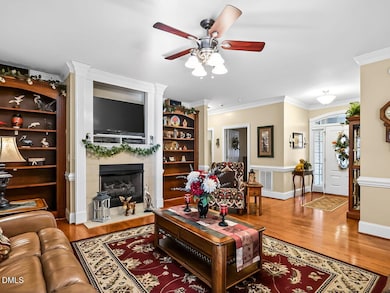
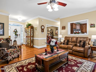
RARE 4 BEDROOM RANCH! This incredible 2,488 SF home ensures everyone has a space to call their own, including 1,351 SF of unfinished space perfect for storage or future expansion. Beautiful hardwood floors lead you into the cozy living room with built-in bookshelves. The kitchen features granite countertops and stainless steel appliances and flows into a sunlit breakfast room, while the dining room boasts a trey ceiling for more formal gatherings. The primary bedroom provides a peaceful retreat, with 3 additional bedrooms offering plenty of room for family, guests, or office space. You'll also enjoy an upstairs bonus room for added flexibility. Step outside to the fenced backyard, perfect for weekend BBQs, playtime, and quiet evenings on the screen porch. A circular driveway adds convenience and ample parking for guests.
Home Details
Home Type
- Single Family
Est. Annual Taxes
- $3,784
Year Built
- Built in 2007
Lot Details
- 0.66 Acre Lot
- Vinyl Fence
- Corner Lot
- Partially Wooded Lot
- Back Yard Fenced and Front Yard
HOA Fees
- $8 Monthly HOA Fees
Parking
- 2 Car Attached Garage
- Side Facing Garage
- Garage Door Opener
- Private Driveway
- 4 Open Parking Spaces
Home Design
- Traditional Architecture
- Brick Foundation
- Shingle Roof
- Vinyl Siding
Interior Spaces
- 2,488 Sq Ft Home
- 1-Story Property
- Bookcases
- Smooth Ceilings
- Ceiling Fan
- Blinds
- Entrance Foyer
- Family Room with Fireplace
- Breakfast Room
- Dining Room
- Bonus Room
- Screened Porch
- Crawl Space
Kitchen
- Free-Standing Electric Range
- Microwave
- Plumbed For Ice Maker
- Dishwasher
- Stainless Steel Appliances
- Granite Countertops
Flooring
- Wood
- Carpet
- Ceramic Tile
Bedrooms and Bathrooms
- 4 Main Level Bedrooms
- Walk-In Closet
- Double Vanity
- Private Water Closet
- Soaking Tub
- Bathtub with Shower
Laundry
- Laundry Room
- Laundry on main level
- Washer and Electric Dryer Hookup
Attic
- Attic Floors
- Permanent Attic Stairs
- Unfinished Attic
Schools
- Riverwood Elementary And Middle School
- Corinth Holder High School
Utilities
- Forced Air Heating and Cooling System
- Septic Tank
- Septic System
- Cable TV Available
Community Details
- Creeks At Millstone HOA, Phone Number (919) 741-5285
- The Creeks At Millstone Subdivision
Listing and Financial Details
- Property held in a trust
- Assessor Parcel Number 16I02038N
Map
Create a Home Valuation Report for This Property
The Home Valuation Report is an in-depth analysis detailing your home's value as well as a comparison with similar homes in the area
Home Values in the Area
Average Home Value in this Area
Tax History
| Year | Tax Paid | Tax Assessment Tax Assessment Total Assessment is a certain percentage of the fair market value that is determined by local assessors to be the total taxable value of land and additions on the property. | Land | Improvement |
|---|---|---|---|---|
| 2025 | $3,786 | $461,510 | $85,000 | $376,510 |
| 2024 | $3,004 | $303,200 | $60,000 | $243,200 |
| 2023 | $3,004 | $303,200 | $60,000 | $243,200 |
| 2022 | $3,034 | $303,200 | $60,000 | $243,200 |
| 2021 | $2,882 | $303,200 | $60,000 | $243,200 |
| 2020 | $2,973 | $303,200 | $60,000 | $243,200 |
| 2019 | $2,973 | $303,200 | $60,000 | $243,200 |
| 2018 | $0 | $268,170 | $50,000 | $218,170 |
| 2017 | $2,631 | $268,170 | $50,000 | $218,170 |
| 2016 | $2,632 | $268,170 | $50,000 | $218,170 |
| 2014 | -- | $268,170 | $50,000 | $218,170 |
Source: Public Records
Property History
| Date | Event | Price | List to Sale | Price per Sq Ft |
|---|---|---|---|---|
| 12/04/2025 12/04/25 | For Sale | $509,000 | -- | $205 / Sq Ft |
Source: Doorify MLS
Purchase History
| Date | Type | Sale Price | Title Company |
|---|---|---|---|
| Deed | -- | None Listed On Document | |
| Deed | -- | None Listed On Document | |
| Warranty Deed | $305,000 | None Available | |
| Warranty Deed | $110,000 | None Available |
Source: Public Records
Mortgage History
| Date | Status | Loan Amount | Loan Type |
|---|---|---|---|
| Previous Owner | $55,000 | Purchase Money Mortgage |
Source: Public Records
About the Listing Agent
Tina Barletta began her professional career serving her country in the Army for over 10 years as a Military Intelligence Officer. After the military, she spent 11 years in the corporate world in a variety of Sales & Marketing positions culminating as a VP of Sales & Marketing for a major biotech corporation. She became a Realtor and Broker over 20 years ago and credits her success to her disciplined military training, leadership skills and years of successful sales and marketing experience. She
Tina's Other Listings
Source: Doorify MLS
MLS Number: 10135795
APN: 16I02038N
Disclaimer: Certain information contained herein is derived from information provided by parties other than Homes.com. All information provided is deemed reliable, but is not guaranteed to be accurate and should be independently verified.
![]() Some IDX listings have been excluded from this IDX display. Brokers make an effort to deliver accurate information, but buyers should independently verify any information on which they will rely in a transaction. The listing broker shall not be responsible for any typographical errors, misinformation, or misprints, and they shall be held totally harmless from any damages arising from reliance upon this data. This data is provided exclusively for consumers’ personal, non-commercial use. Listings marked with an icon are provided courtesy of the Doorify MLS, Inc. of North Carolina, Internet Data Exchange Database. Closed (sold) listings may have been listed and/or sold by a real estate firm other than the firm(s) featured on this website. Closed data is not available until the sale of the property is recorded in the MLS. Home sale data is not an appraisal, CMA, competitive or comparative market analysis, or home valuation of any property. Copyright 2025 Doorify MLS, Inc. of North Carolina. All rights reserved.
Some IDX listings have been excluded from this IDX display. Brokers make an effort to deliver accurate information, but buyers should independently verify any information on which they will rely in a transaction. The listing broker shall not be responsible for any typographical errors, misinformation, or misprints, and they shall be held totally harmless from any damages arising from reliance upon this data. This data is provided exclusively for consumers’ personal, non-commercial use. Listings marked with an icon are provided courtesy of the Doorify MLS, Inc. of North Carolina, Internet Data Exchange Database. Closed (sold) listings may have been listed and/or sold by a real estate firm other than the firm(s) featured on this website. Closed data is not available until the sale of the property is recorded in the MLS. Home sale data is not an appraisal, CMA, competitive or comparative market analysis, or home valuation of any property. Copyright 2025 Doorify MLS, Inc. of North Carolina. All rights reserved.
Nearby Homes
- 148 Helena Ln
- 629 Woodson Dr
- 211 Wheeler Ct
- 524 Woodson Dr
- 109 Hutson Ln
- 117 Landry Ct
- 102 Fontana Dr
- 380 Collinsworth Dr
- 201 Sarazen Dr
- 104 S Woodstone Dr
- 320 Chamberlain Dr
- 329 Chamberlain Dr
- 400 Charleston Dr
- 328 Mccarthy Dr
- 200 Mantle Dr
- 501 Sarazen Dr
- 237 Boswell Ln
- 304 Nelson Ln
- 204 Aldean Dr
- 148 Gasper Ct
- 77 Ballancer Way
- 117 Pearson Place
- 144 Hutson Ln
- 228 Pearson Place
- 376 Collinsworth Dr
- 305 Chamberlain Dr
- 113 Houston Ln
- 126 S Woodstone Dr
- 268 E Webber Ln
- 216 Boswell Ln
- 232 Lanier Place
- 112 Spalding Ln
- 308 Nelson Ln
- 76 Ashby Dr
- 35 Wensley Ct
- 91 Cottage Dr
- 60 Anderby Dr
- 31 Stewarts Knob Dr
- 3666 E Cotton Gin Dr
- 129 Longleaf Pine St