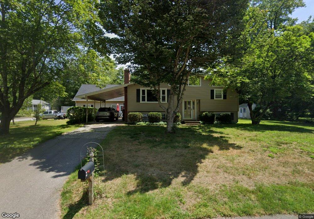
32 Currier Rd MerriMacK, NH 03054
Estimated Value: $510,000 - $552,000
3
Beds
1
Bath
1,790
Sq Ft
$297/Sq Ft
Est. Value
About This Home
This home is located at 32 Currier Rd, MerriMacK, NH 03054 and is currently estimated at $531,043, approximately $296 per square foot. 32 Currier Rd is a home located in Hillsborough County with nearby schools including James Mastricola Elementary School, James Mastricola Upper Elementary School, and Merrimack Middle School.
Ownership History
Date
Name
Owned For
Owner Type
Purchase Details
Closed on
Sep 16, 2019
Sold by
Stlaurent James P and Stlaurent Lea M
Bought by
Stlaurent Ft
Current Estimated Value
Purchase Details
Closed on
Jul 1, 1994
Bought by
Stlaurent James P and Stlaurent Lea M
Create a Home Valuation Report for This Property
The Home Valuation Report is an in-depth analysis detailing your home's value as well as a comparison with similar homes in the area
Home Values in the Area
Average Home Value in this Area
Purchase History
| Date | Buyer | Sale Price | Title Company |
|---|---|---|---|
| Stlaurent Ft | -- | -- | |
| Stlaurent James P | $104,000 | -- |
Source: Public Records
Mortgage History
| Date | Status | Borrower | Loan Amount |
|---|---|---|---|
| Previous Owner | Stlaurent James P | $157,000 | |
| Previous Owner | Stlaurent James P | $164,000 | |
| Previous Owner | Stlaurent James P | $25,000 | |
| Previous Owner | Stlaurent James P | $172,500 |
Source: Public Records
Tax History Compared to Growth
Tax History
| Year | Tax Paid | Tax Assessment Tax Assessment Total Assessment is a certain percentage of the fair market value that is determined by local assessors to be the total taxable value of land and additions on the property. | Land | Improvement |
|---|---|---|---|---|
| 2024 | $7,864 | $380,100 | $200,900 | $179,200 |
| 2023 | $7,362 | $378,500 | $200,900 | $177,600 |
| 2022 | $6,578 | $378,500 | $200,900 | $177,600 |
| 2021 | $6,499 | $378,500 | $200,900 | $177,600 |
| 2020 | $6,395 | $265,800 | $136,100 | $129,700 |
| 2019 | $6,402 | $265,300 | $136,100 | $129,200 |
| 2018 | $6,521 | $265,300 | $136,100 | $129,200 |
| 2017 | $6,200 | $265,300 | $136,100 | $129,200 |
| 2016 | $6,046 | $265,300 | $136,100 | $129,200 |
| 2015 | $5,896 | $238,500 | $116,500 | $122,000 |
| 2014 | $5,745 | $238,500 | $116,500 | $122,000 |
| 2013 | $5,638 | $235,800 | $116,500 | $119,300 |
Source: Public Records
Map
Nearby Homes
- 8 Highland Green Ln
- 3 Independence Dr
- 7 Hadley Rd
- 98 Indian Rock Rd
- 7 Beacon Dr
- 5 Fernwood Dr
- 5 Lynn Dr
- 14 Mayflower Dr
- 22 Clay St
- 40 Turkey Hill Rd
- 27 Sarah Dr
- 8 Donovan Ct
- 77 E Ridge Rd
- 23 Pondview Dr
- 38 Mallard Point
- 12 Clinton Ct
- 22 Essex Green Ct
- 11 Essex Green Ct
- 10 Kingston Ct Unit 10
- 19 Vista Way