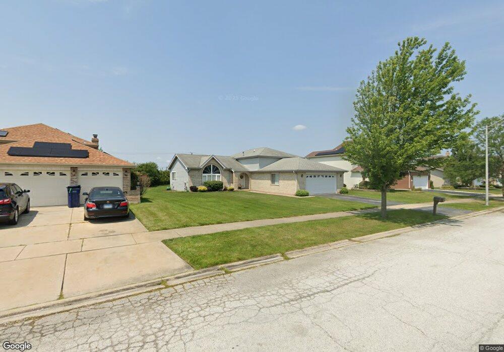
32 Denise Ct Matteson, IL 60443
West Matteson NeighborhoodEstimated Value: $282,000 - $352,000
3
Beds
3
Baths
1,454
Sq Ft
$214/Sq Ft
Est. Value
About This Home
This home is located at 32 Denise Ct, Matteson, IL 60443 and is currently estimated at $311,317, approximately $214 per square foot. 32 Denise Ct is a home located in Cook County with nearby schools including Colin Powell Middle School and Dr. Wolfe's Montessori School.
Ownership History
Date
Name
Owned For
Owner Type
Purchase Details
Closed on
Apr 26, 2000
Sold by
Bank Of Homewood
Bought by
Seawood Cecelia A
Current Estimated Value
Home Financials for this Owner
Home Financials are based on the most recent Mortgage that was taken out on this home.
Original Mortgage
$135,000
Outstanding Balance
$44,086
Interest Rate
8.21%
Estimated Equity
$267,231
Create a Home Valuation Report for This Property
The Home Valuation Report is an in-depth analysis detailing your home's value as well as a comparison with similar homes in the area
Home Values in the Area
Average Home Value in this Area
Purchase History
| Date | Buyer | Sale Price | Title Company |
|---|---|---|---|
| Seawood Cecelia A | $182,000 | -- |
Source: Public Records
Mortgage History
| Date | Status | Borrower | Loan Amount |
|---|---|---|---|
| Open | Seawood Cecelia A | $135,000 |
Source: Public Records
Tax History
| Year | Tax Paid | Tax Assessment Tax Assessment Total Assessment is a certain percentage of the fair market value that is determined by local assessors to be the total taxable value of land and additions on the property. | Land | Improvement |
|---|---|---|---|---|
| 2025 | $7,889 | $25,000 | $5,784 | $19,216 |
| 2024 | $7,889 | $25,000 | $5,784 | $19,216 |
| 2023 | $5,651 | $25,000 | $5,784 | $19,216 |
| 2022 | $5,651 | $16,712 | $4,995 | $11,717 |
| 2021 | $5,791 | $16,711 | $4,995 | $11,716 |
| 2020 | $7,107 | $16,711 | $4,995 | $11,716 |
| 2019 | $6,301 | $14,961 | $4,469 | $10,492 |
| 2018 | $6,206 | $14,961 | $4,469 | $10,492 |
| 2017 | $6,066 | $14,961 | $4,469 | $10,492 |
| 2016 | $6,834 | $15,704 | $3,943 | $11,761 |
| 2015 | $6,647 | $15,704 | $3,943 | $11,761 |
| 2014 | $6,864 | $16,454 | $3,943 | $12,511 |
| 2013 | $6,377 | $16,491 | $3,943 | $12,548 |
Source: Public Records
Map
Nearby Homes
- 34 Wedgewood Rd
- 10 Wedgewood Rd
- 56 Timberlane Rd
- 12 Iliad Dr
- 42 Pheasant Rd
- 433 Wheatfield Rd
- 5943 Woodgate Dr
- 6226 Beechwood Rd
- 25 Pheasant Rd
- 123 Oriole Rd
- 5911 Timberlane Rd
- 13 Oakview Rd
- 6230 Streamwood Ln
- 152 Oakhurst Rd
- 37 Corinth Dr
- 6306 Beaver Dam Rd
- 5838 Woodgate Dr
- 111 Deerpath Rd
- 156 Cloverleaf Rd
- 116 Cloverleaf Rd
- 28 Denise Ct
- 36 Denise Ct
- 77 Ridgeland Ave Call Me at 773 874 9637 2
- 24 Denise Ct
- 29 Denise Ct
- 33 Denise Ct
- 25 Denise Ct
- 20 Denise Ct
- 45 Denise Ct
- 21 Denise Ct
- 41 Denise Ct
- 37 Denise Ct
- 16 Denise Ct
- 6358 Applehill Rd
- 40 Red Barn Rd
- 6348 Applehill Rd
- 12 Denise Ct
- 6338 Applehill Rd
- 30 Red Barn Rd
- 6328 Applehill Rd