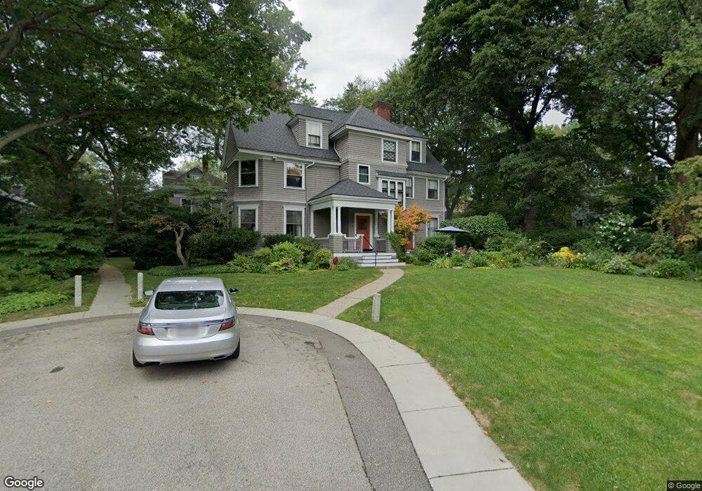
32 Hubbard Park Rd Cambridge, MA 02138
West Cambridge NeighborhoodEstimated Value: $4,440,000 - $6,015,616
8
Beds
5
Baths
4,378
Sq Ft
$1,238/Sq Ft
Est. Value
About This Home
This home is located at 32 Hubbard Park Rd, Cambridge, MA 02138 and is currently estimated at $5,420,205, approximately $1,238 per square foot. 32 Hubbard Park Rd is a home located in Middlesex County with nearby schools including St Peter School, Cambridge Montessori School, and Buckingham Browne & Nichols School.
Ownership History
Date
Name
Owned For
Owner Type
Purchase Details
Closed on
Mar 6, 2020
Sold by
Gonson S Donald S and Gonson Dorothy R
Bought by
32 Hubbard Park Rt
Current Estimated Value
Purchase Details
Closed on
Dec 4, 1972
Bought by
Gonson S Donald
Create a Home Valuation Report for This Property
The Home Valuation Report is an in-depth analysis detailing your home's value as well as a comparison with similar homes in the area
Home Values in the Area
Average Home Value in this Area
Purchase History
| Date | Buyer | Sale Price | Title Company |
|---|---|---|---|
| 32 Hubbard Park Rt | -- | None Available | |
| Gonson S Donald | $97,000 | -- |
Source: Public Records
Tax History Compared to Growth
Tax History
| Year | Tax Paid | Tax Assessment Tax Assessment Total Assessment is a certain percentage of the fair market value that is determined by local assessors to be the total taxable value of land and additions on the property. | Land | Improvement |
|---|---|---|---|---|
| 2025 | $33,097 | $5,212,100 | $2,950,300 | $2,261,800 |
| 2024 | $29,964 | $5,061,500 | $2,926,700 | $2,134,800 |
| 2023 | $27,895 | $4,760,300 | $2,914,900 | $1,845,400 |
| 2022 | $25,393 | $4,289,400 | $2,656,300 | $1,633,100 |
| 2021 | $24,128 | $4,124,500 | $2,606,700 | $1,517,800 |
| 2020 | $22,611 | $3,932,300 | $2,494,600 | $1,437,700 |
| 2019 | $20,366 | $3,428,700 | $2,101,400 | $1,327,300 |
| 2018 | $19,530 | $3,356,400 | $2,090,500 | $1,265,900 |
| 2017 | $20,621 | $3,177,400 | $1,993,600 | $1,183,800 |
| 2016 | $19,706 | $2,819,100 | $1,724,200 | $1,094,900 |
| 2015 | $20,281 | $2,593,500 | $1,616,400 | $977,100 |
| 2014 | $21,262 | $2,537,200 | $1,573,400 | $963,800 |
Source: Public Records
Map
Nearby Homes
- 48 Hubbard Park Rd
- 15 Hubbard Park Rd
- 158 Brattle St
- 153 Brattle St
- 20 Maynard Place
- 172 Brattle St
- 1010 Memorial Dr Unit 6G
- 234 Huron Ave
- 3 Berkeley Place
- 32 Hawthorn St
- 12 Berkeley St
- 71-73 Reservoir St
- 22 Concord Ave Unit 10
- 148 Huron Ave
- 422-424 Walden St
- 988 Memorial Dr Unit 386
- 382 Huron Ave
- 52 Garden St Unit B2
- 44 Garden St
- 134 Lexington Ave Unit 2
- 26 Hubbard Park Rd
- 8 Lowell St
- 154 Brattle St
- 154 Brattle St Unit 2
- 4 Lowell St
- 20 Hubbard Park Rd
- 10 Lowell St
- 19 Hubbard Park Rd
- 156 Brattle St
- 140 Foster St
- 140 Foster St Unit 1
- 140 Foster St
- 140 Foster St Unit 4
- 148 Foster St
- 150 Brattle St
- 16 Lowell St
- 43 Gibson St
- 14 Hubbard Park Rd
- 40 Gibson St
- 40 Gibson St Unit 3