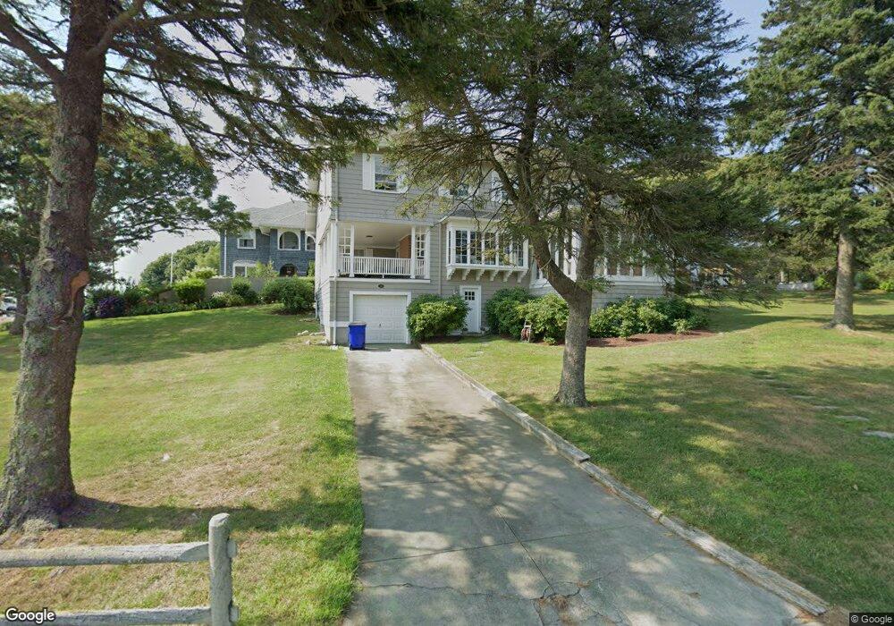
32 Maryland Ave Bourne, MA 02532
Monument Beach NeighborhoodEstimated Value: $1,161,000 - $1,535,000
5
Beds
4
Baths
3,264
Sq Ft
$405/Sq Ft
Est. Value
About This Home
This home is located at 32 Maryland Ave, Bourne, MA 02532 and is currently estimated at $1,322,168, approximately $405 per square foot. 32 Maryland Ave is a home located in Barnstable County with nearby schools including Bourne High School, St Margaret Regional School, and Cadence Academy Preschool - Bourne.
Ownership History
Date
Name
Owned For
Owner Type
Purchase Details
Closed on
Jul 22, 2020
Sold by
Dougherty James D and Ford Elizabeth P
Bought by
Dougherty Ford Rt and Dougherty
Current Estimated Value
Purchase Details
Closed on
Dec 16, 2011
Sold by
White Kevin H
Bought by
Dougherty James D and Dougherty Elizabeth P
Purchase Details
Closed on
Jun 25, 2007
Sold by
White Kathryn
Bought by
White Kevin H
Create a Home Valuation Report for This Property
The Home Valuation Report is an in-depth analysis detailing your home's value as well as a comparison with similar homes in the area
Home Values in the Area
Average Home Value in this Area
Purchase History
| Date | Buyer | Sale Price | Title Company |
|---|---|---|---|
| Dougherty Ford Rt | -- | None Available | |
| Dougherty Ford Rt | -- | None Available | |
| Dougherty James D | $600,000 | -- | |
| Dougherty James D | $600,000 | -- | |
| White Kevin H | -- | -- | |
| White Kevin H | -- | -- |
Source: Public Records
Tax History Compared to Growth
Tax History
| Year | Tax Paid | Tax Assessment Tax Assessment Total Assessment is a certain percentage of the fair market value that is determined by local assessors to be the total taxable value of land and additions on the property. | Land | Improvement |
|---|---|---|---|---|
| 2025 | $8,103 | $1,037,500 | $518,400 | $519,100 |
| 2024 | $7,924 | $988,000 | $493,700 | $494,300 |
| 2023 | $7,703 | $874,300 | $437,000 | $437,300 |
| 2022 | $7,404 | $733,800 | $386,700 | $347,100 |
| 2021 | $7,192 | $667,800 | $351,900 | $315,900 |
| 2020 | $7,197 | $670,100 | $348,600 | $321,500 |
| 2019 | $6,853 | $652,000 | $348,600 | $303,400 |
| 2018 | $6,544 | $620,900 | $332,000 | $288,900 |
| 2017 | $6,274 | $609,100 | $323,000 | $286,100 |
| 2016 | $5,760 | $566,900 | $323,000 | $243,900 |
| 2015 | $5,709 | $566,900 | $323,000 | $243,900 |
Source: Public Records
Map
Nearby Homes
- 18 Carlton Rd
- 203 County Rd
- 12 Beachwood Rd
- 18 Quaker Ln
- 18 Douglas Ave
- 105 Clay Pond Rd
- 13 Laurel Hill Ct
- 16 Amberwood Ct
- 30 Howard Ave
- 34 Turnberry Rd
- 440 County Rd
- 12 Turnberry Rd Unit 12
- 112 Clay Pond Rd
- 26 Carnoustie Rd
- 5 Sea Knoll Ct
- 93 Valley Bars Rd
- 4 Hollyhock Knoll Ct Unit 4
- 4 Hollyhock Knoll Ct Unit 4
- 1 Hollyhock Knoll Ct Unit 1