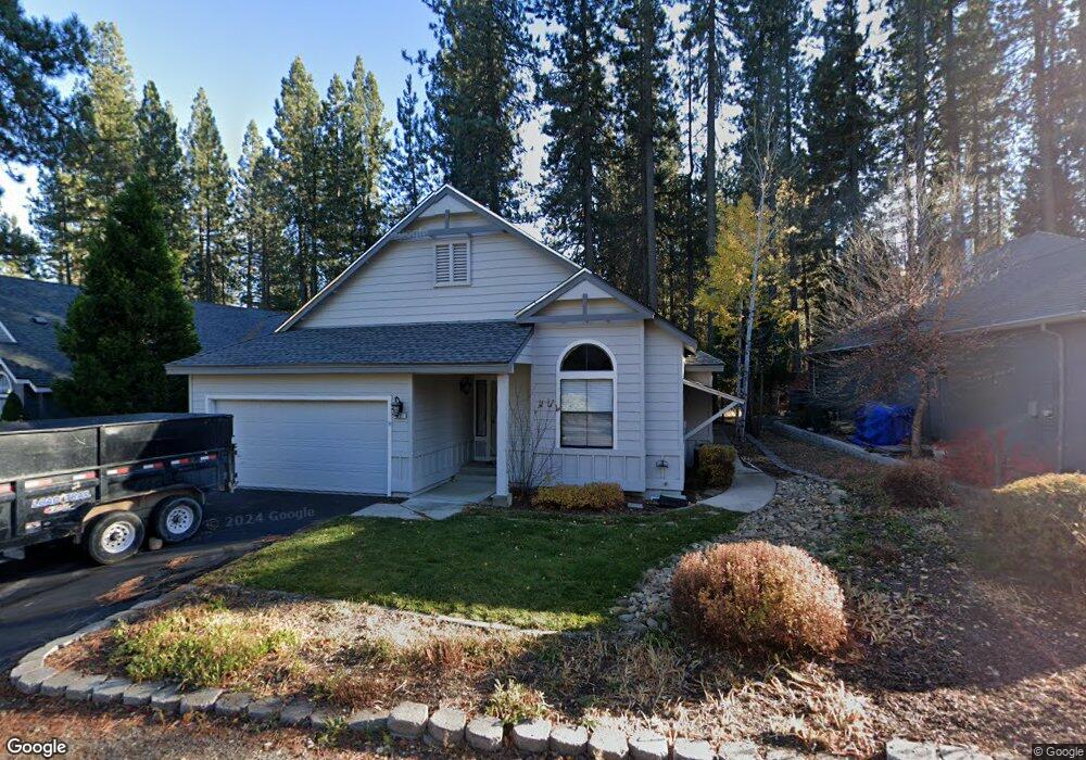
32 Sequoia Cir Blairsden-Graeagle, CA 96103
Estimated Value: $398,000 - $460,000
3
Beds
2
Baths
1,479
Sq Ft
$283/Sq Ft
Est. Value
About This Home
This home is located at 32 Sequoia Cir, Blairsden-Graeagle, CA 96103 and is currently estimated at $418,974, approximately $283 per square foot. 32 Sequoia Cir is a home located in Plumas County.
Ownership History
Date
Name
Owned For
Owner Type
Purchase Details
Closed on
Oct 26, 2020
Sold by
Anderson Bruce F and Anderson Nancy A
Bought by
Anderson Bruce F and Anderson Nancy A
Current Estimated Value
Purchase Details
Closed on
Oct 1, 2008
Sold by
Anderson Nancy A and Anderson Nancy Dee
Bought by
Anderson Bruce F and Anderson Nancy A
Home Financials for this Owner
Home Financials are based on the most recent Mortgage that was taken out on this home.
Original Mortgage
$125,000
Interest Rate
6.43%
Mortgage Type
New Conventional
Purchase Details
Closed on
Jul 21, 2008
Sold by
Ashby Aleene
Bought by
Anderson Nancy A and Anderson Bruce F
Create a Home Valuation Report for This Property
The Home Valuation Report is an in-depth analysis detailing your home's value as well as a comparison with similar homes in the area
Purchase History
| Date | Buyer | Sale Price | Title Company |
|---|---|---|---|
| Anderson Bruce F | -- | Fidelity National Title | |
| Anderson Bruce F | -- | California Counties Title | |
| Anderson Nancy A | -- | None Available |
Source: Public Records
Mortgage History
| Date | Status | Borrower | Loan Amount |
|---|---|---|---|
| Previous Owner | Anderson Bruce F | $125,000 |
Source: Public Records
Tax History
| Year | Tax Paid | Tax Assessment Tax Assessment Total Assessment is a certain percentage of the fair market value that is determined by local assessors to be the total taxable value of land and additions on the property. | Land | Improvement |
|---|---|---|---|---|
| 2025 | $2,790 | $265,700 | $62,695 | $203,005 |
| 2023 | $2,790 | $255,384 | $60,261 | $195,123 |
| 2022 | $2,717 | $250,378 | $59,080 | $191,298 |
| 2021 | $2,636 | $245,470 | $57,922 | $187,548 |
| 2020 | $2,697 | $242,954 | $57,329 | $185,625 |
| 2019 | $2,643 | $238,191 | $56,205 | $181,986 |
| 2018 | $2,528 | $233,521 | $55,103 | $178,418 |
| 2017 | $2,515 | $228,943 | $54,023 | $174,920 |
| 2016 | $2,313 | $224,455 | $52,964 | $171,491 |
| 2015 | $2,281 | $221,085 | $52,169 | $168,916 |
| 2014 | -- | $216,756 | $51,148 | $165,608 |
Source: Public Records
Map
Nearby Homes
- 110 Cottonwood Dr
- 142 Cottonwood Dr
- 16 Alder Ct
- 219 Tamarack Place
- 133 Cottonwood Dr
- 101 Poplar Valley Rd
- 33 Poplar Ct
- 392 Sequoia Cir
- 325 Eureka Springs Dr
- 16 Mohave Trail
- 375 Eureka Springs Dr
- 137 Eureka Springs Dr
- 6 Pine Tree Ct
- 300 Blue Jay Dr Unit C Road
- 300 Blue Jay Dr
- 312 Lundy Ln
- 9 Aspen Cir
- 25 Aspen Cir
- 105 W Ponderosa Dr
- 96 W Ponderosa Dr
- 44 Sequoia Cir
- 56 Sequoia Cir
- 116 Cottonwood Dr
- 64 Sequoia Cir
- 8 Alder Ct
- 35 Sequoia Cir
- 72 Sequoia Cir
- 192 Cottonwood Dr
- 114 Cottonwood Dr
- 82 Sequoia Cir
- 71 Sequoia Cir
- 26 Alder Ct
- 112 Cottonwood Dr
- 35 Alder Ct
- 90 Sequoia Cir
- 81 Sequoia Cir
- 117 Cottonwood Dr
- 119 Cottonwood Dr
- 34 Alder Ct
- 121 Cottonwood Dr
Your Personal Tour Guide
Ask me questions while you tour the home.