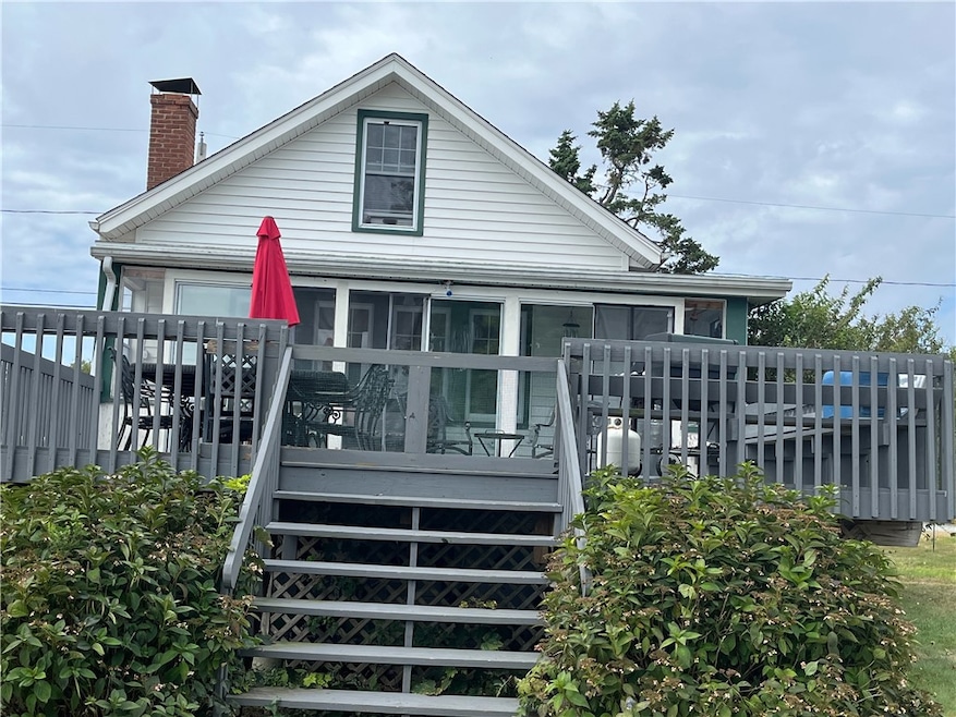
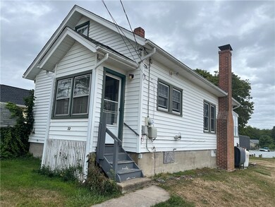


32 Shore Dr Charlestown, RI 02813
Highlights
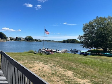
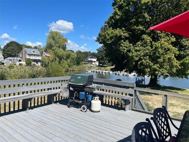
- Beach Front
- Marina
- Furnished
- Chariho High School Rated 10
- Wood Flooring
- No HOA
About This Home
September 2025 to May 15th 2026 rental. Charming 2 bedrooms, 2 baths waterfront Cottage with beautiful views. Perfect week-end/getaway house in peaceful Charlestown.
Home Details
Home Type
- Single Family
Est. Annual Taxes
- $5,345
Year Built
- 1935
Lot Details
- 0.28 Acre Lot
- Beach Front
Parking
- No Garage
Home Design
- Shingle Siding
Interior Spaces
- 850 Sq Ft Home
- 2-Story Property
- Furnished
- Wood Flooring
- Water Views
- Unfinished Basement
- Crawl Space
Kitchen
- Oven
- Range
- Microwave
Bedrooms and Bathrooms
- 2 Bedrooms
- 2 Full Bathrooms
Laundry
- Laundry in unit
- Dryer
- Washer
Location
- Property near a hospital
Utilities
- No Cooling
- Heating System Uses Oil
- Hot Water Heating System
- Private Water Source
- Well
- Gas Water Heater
- Septic Tank
Listing and Financial Details
- Property Available on 9/2/25
- Month-to-Month Lease Term
- Assessor Parcel Number 32SHOREDRCHAR
Community Details
Overview
- No Home Owners Association
- Charlestown Bythe Sea Subdivision
Amenities
- Restaurant
Recreation
- Marina
- Tennis Courts
Pet Policy
- No Pets Allowed
Map
Source: State-Wide MLS
MLS Number: 1393365
APN: CHAR-000009-000000-000280
Disclaimer: Certain information contained herein is derived from information provided by parties other than Homes.com. All information provided is deemed reliable, but is not guaranteed to be accurate and should be independently verified.
![]() IDX information is provided exclusively for personal, non-commercial use, and may not be used for any purpose other than to identify prospective properties consumers may be interested in purchasing. Information is deemed reliable but not guaranteed.
IDX information is provided exclusively for personal, non-commercial use, and may not be used for any purpose other than to identify prospective properties consumers may be interested in purchasing. Information is deemed reliable but not guaranteed.
Copyright © 2025 State-Wide MLS, Inc. All rights reserved.
- 19 Traymore St
- 130 S Niantic Dr
- 15 Charlestown Rd
- 14 Charlestown Rd
- 63 Aspen Rd
- 150 Southern Way
- 21 Browning Dr
- 350 Narrow Ln
- 0 Falcone Ln
- 107 Wild Goose Rd
- 15 Josephine Dr
- 49 West Way
- 156 Green Hill Ocean Dr
- 40 Alder Rd
- 16 Center St
- 14 Lakeside Dr
- 10 Josephine Dr Unit 2D
- 4459 Old Post Rd
- 108 Balsam Rd
- 61 Slope Ave
- 278 Charlestown Beach Rd
- 32 5th Ave
- 3 Henley St
- 36 Burnham St
- 57 Sheila Dr
- 72 Elm Rd
- 121 Balsam Rd
- 3865 Old Post Rd
- 126 Alder Rd
- 295 Carpenter Dr
- 283 Balsam Rd
- 45 Hannas Rd
- 54 Metaterraine Ave
- 21 Woodsia Trail
- 14 E Pointe Ct Unit 14
- 24 Westside Rd
- 100 Hull St
- 20 Wagner Rd
- 271 Great Island Rd Unit B
- 29 Canterbury Dr
