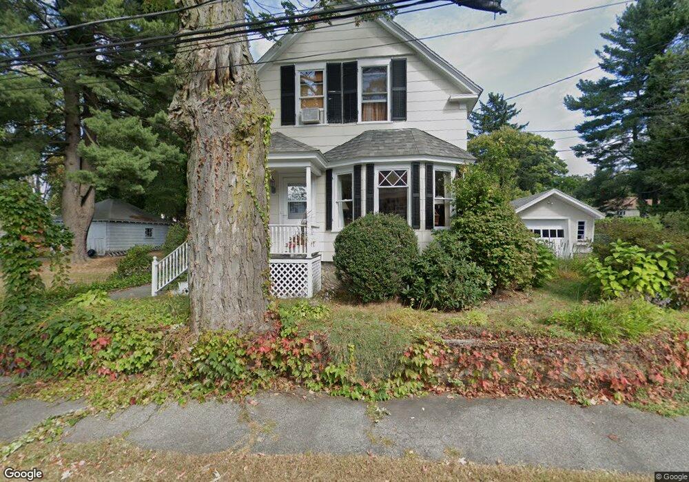
32 Thorndike Rd North Andover, MA 01845
Estimated Value: $651,000 - $719,000
3
Beds
2
Baths
1,605
Sq Ft
$421/Sq Ft
Est. Value
About This Home
This home is located at 32 Thorndike Rd, North Andover, MA 01845 and is currently estimated at $674,977, approximately $420 per square foot. 32 Thorndike Rd is a home located in Essex County with nearby schools including Thomson Elementary School, North Andover Middle School, and North Andover High School.
Ownership History
Date
Name
Owned For
Owner Type
Purchase Details
Closed on
Jul 28, 2025
Sold by
Giacalone Joseph J and Giacalone Rosalie S
Bought by
Giacalone Ft and Giacalone
Current Estimated Value
Purchase Details
Closed on
Oct 16, 2017
Sold by
Giacalone Rosalie S
Bought by
Giacalone Joseph and Giacalone Rosalie S
Purchase Details
Closed on
Aug 27, 1997
Sold by
Allen Marion L
Bought by
Giacalone Jon E
Create a Home Valuation Report for This Property
The Home Valuation Report is an in-depth analysis detailing your home's value as well as a comparison with similar homes in the area
Home Values in the Area
Average Home Value in this Area
Purchase History
| Date | Buyer | Sale Price | Title Company |
|---|---|---|---|
| Giacalone Ft | -- | -- | |
| Giacalone Ft | -- | -- | |
| Giacalone Joseph | -- | -- | |
| Giacalone Joseph | -- | -- | |
| Giacalone Jon E | $140,000 | -- | |
| Giacalone Jon E | $140,000 | -- |
Source: Public Records
Mortgage History
| Date | Status | Borrower | Loan Amount |
|---|---|---|---|
| Previous Owner | Giacalone Jon E | $121,400 | |
| Previous Owner | Giacalone Jon E | $180,000 | |
| Previous Owner | Giacalone Jon E | $30,000 |
Source: Public Records
Tax History Compared to Growth
Tax History
| Year | Tax Paid | Tax Assessment Tax Assessment Total Assessment is a certain percentage of the fair market value that is determined by local assessors to be the total taxable value of land and additions on the property. | Land | Improvement |
|---|---|---|---|---|
| 2025 | $6,227 | $553,000 | $308,000 | $245,000 |
| 2024 | $5,860 | $528,400 | $289,900 | $238,500 |
| 2023 | $5,771 | $471,500 | $266,300 | $205,200 |
| 2022 | $5,692 | $420,700 | $239,200 | $181,500 |
| 2021 | $5,463 | $385,500 | $217,400 | $168,100 |
| 2020 | $5,297 | $385,500 | $217,400 | $168,100 |
| 2019 | $5,506 | $410,600 | $217,400 | $193,200 |
| 2018 | $5,966 | $410,600 | $217,400 | $193,200 |
| 2017 | $5,034 | $352,500 | $182,700 | $169,800 |
| 2016 | $5,030 | $352,500 | $179,200 | $173,300 |
| 2015 | $4,619 | $321,000 | $173,100 | $147,900 |
Source: Public Records
Map
Nearby Homes
- 62 Brightwood Ave
- 29 Brightwood Ave
- 385 Sutton St
- 148 Main St Unit A508
- 148 Main St Unit C538
- 148 Main St Unit A307
- 826 Osgood St
- 64 2nd St
- 12 Walker Rd Unit 6
- 68 Belmont St Unit 68
- 68 Union St
- 127 Marblehead St Unit A
- 13 Woodland St
- 75 Beverly St Unit 75
- 52 Howard St
- 0 Great Pond Rd
- 7 Stevens Ct
- 11 W Bradstreet Rd
- 317 Middlesex St
- 33 Herrick Rd
- 5 Irving Rd
- 35 Thorndike Rd Unit 1
- 46 Thorndike Rd
- 24 Thorndike Rd
- 33 Thorndike Rd
- 41 Thorndike Rd
- 41 Thorndike Rd Unit 3
- 41 Thorndike Rd Unit 2
- 21 Irving Rd
- 27 Thorndike Rd
- 53 Thorndike Rd Unit 2
- 53 Thorndike Rd
- 51 Thorndike Rd
- 16 Irving Rd
- 2 Irving Rd
- 56 Thorndike Rd
- 25 Thorndike Rd
- 22 Irving Rd
- 30 Troy Rd
- 6 Thorndike Rd