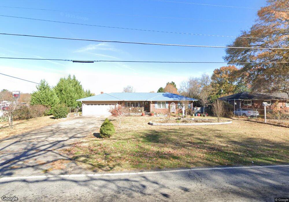
320 Lewis St Anderson, SC 29624
Estimated Value: $157,041 - $223,000
--
Bed
--
Bath
1,570
Sq Ft
$123/Sq Ft
Est. Value
About This Home
This home is located at 320 Lewis St, Anderson, SC 29624 and is currently estimated at $193,010, approximately $122 per square foot. 320 Lewis St is a home located in Anderson County with nearby schools including Varennes Elementary School, Robert Anderson Middle School, and Westside High School.
Ownership History
Date
Name
Owned For
Owner Type
Purchase Details
Closed on
Mar 20, 2025
Sold by
Stansell Anne E and Stroud Anne
Bought by
Stansell Anne E and Stroud Anne
Current Estimated Value
Purchase Details
Closed on
Oct 11, 2017
Sold by
Stroud Anne and Stansell Anne E
Bought by
Stroud Anne
Purchase Details
Closed on
Aug 19, 2010
Sold by
Stansell Anne E and Stansell Anne
Bought by
Zappitella Cynthia Ann and Stansell Anne E
Purchase Details
Closed on
Oct 2, 2001
Sold by
Norris Eleanor M
Bought by
Stansell Johnny M
Create a Home Valuation Report for This Property
The Home Valuation Report is an in-depth analysis detailing your home's value as well as a comparison with similar homes in the area
Home Values in the Area
Average Home Value in this Area
Purchase History
| Date | Buyer | Sale Price | Title Company |
|---|---|---|---|
| Stansell Anne E | -- | None Listed On Document | |
| Stroud Anne | -- | None Available | |
| Zappitella Cynthia Ann | -- | -- | |
| Stansell Johnny M | $85,000 | -- |
Source: Public Records
Tax History Compared to Growth
Tax History
| Year | Tax Paid | Tax Assessment Tax Assessment Total Assessment is a certain percentage of the fair market value that is determined by local assessors to be the total taxable value of land and additions on the property. | Land | Improvement |
|---|---|---|---|---|
| 2024 | $386 | $5,260 | $400 | $4,860 |
| 2023 | $386 | $5,260 | $400 | $4,860 |
| 2022 | $386 | $5,260 | $400 | $4,860 |
| 2021 | $325 | $4,510 | $420 | $4,090 |
| 2020 | $323 | $4,510 | $420 | $4,090 |
| 2019 | $323 | $4,510 | $420 | $4,090 |
| 2018 | $328 | $4,510 | $420 | $4,090 |
| 2017 | -- | $4,510 | $420 | $4,090 |
| 2016 | $184 | $4,240 | $400 | $3,840 |
| 2015 | $188 | $4,240 | $400 | $3,840 |
| 2014 | $188 | $4,240 | $400 | $3,840 |
Source: Public Records
Map
Nearby Homes
- 612 Martha Dr
- 431 Lewis St
- 00 Hwy 28 Bypass New Pond Rd
- 719 Dora Dr
- 46 S Lyons St
- 16 N Prince St
- 114 Hillcrest Cir Unit A
- 114 Hillcrest Cir
- 701 Delia St
- 701 Delia St Unit B
- 701 Delia St Unit A
- 1606 S Murray Avenue Extension
- 112 Flowe Rd
- 6 Herring Ave
- 222 Hillcrest Cir
- 3308 New Pond Rd
- 1103 Scott Dr
- 00 Ila St
- 720 722 Gary St
- 410 W Shockley Ferry Rd
- 318 Lewis St
- 313 Lyonswood Dr
- 316 Lewis St
- 311 Lyonswood Dr
- 311 Lyonswood Dr Unit 311 Lyonswood Drive
- 309 Lyonswood Dr
- 315 Lewis St
- 314 Lewis St
- 818 Sayre St
- 401 Lewis St
- 635 Martha Dr
- 307 Lyonswood Dr
- 804 Highway 29 S
- 312 Lewis St
- 636 Martha Dr
- 313 Lewis St
- 202 Frampton St
- 902 Highway 29 S
- 800 Highway 29 S
- 310 Lyonswood Dr