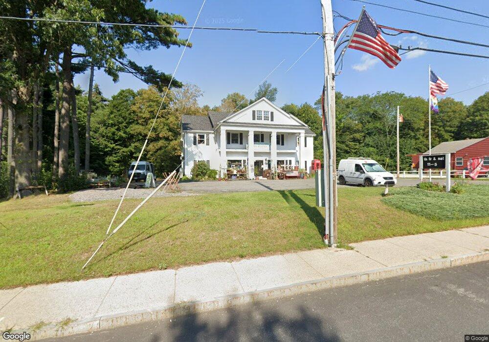
320 Main St Sturbridge, MA 01566
Estimated Value: $590,468
3
Beds
2
Baths
5,600
Sq Ft
$105/Sq Ft
Est. Value
About This Home
This home is located at 320 Main St, Sturbridge, MA 01566 and is currently estimated at $590,468, approximately $105 per square foot. 320 Main St is a home located in Worcester County with nearby schools including Burgess Elementary School, Tantasqua Regional Junior High School, and Tantasqua Regional High School.
Ownership History
Date
Name
Owned For
Owner Type
Purchase Details
Closed on
Jul 17, 2020
Sold by
Lawrence C Boniface Irt
Bought by
Boniface Laurie L
Current Estimated Value
Purchase Details
Closed on
Jan 24, 2014
Sold by
Boniface Lawrence
Bought by
Ir Lawrence C Boniface
Purchase Details
Closed on
Nov 14, 2003
Sold by
Piligian Elise and Zikos Lucine
Bought by
Boniface Lawrence
Create a Home Valuation Report for This Property
The Home Valuation Report is an in-depth analysis detailing your home's value as well as a comparison with similar homes in the area
Home Values in the Area
Average Home Value in this Area
Purchase History
| Date | Buyer | Sale Price | Title Company |
|---|---|---|---|
| Boniface Laurie L | $427,000 | None Available | |
| Ir Lawrence C Boniface | -- | -- | |
| Boniface Lawrence | $420,000 | -- |
Source: Public Records
Mortgage History
| Date | Status | Borrower | Loan Amount |
|---|---|---|---|
| Previous Owner | Ir Lawrence C Boniface | $160,000 | |
| Previous Owner | Ir Lawrence C Boniface | $40,000 | |
| Previous Owner | Ir Lawrence C Boniface | $120,000 |
Source: Public Records
Tax History
| Year | Tax Paid | Tax Assessment Tax Assessment Total Assessment is a certain percentage of the fair market value that is determined by local assessors to be the total taxable value of land and additions on the property. | Land | Improvement |
|---|---|---|---|---|
| 2025 | $10,194 | $639,900 | $141,400 | $498,500 |
| 2024 | $9,805 | $594,600 | $138,700 | $455,900 |
| 2023 | $9,339 | $516,800 | $120,400 | $396,400 |
| 2022 | $9,023 | $471,200 | $108,800 | $362,400 |
| 2021 | $9,584 | $503,900 | $108,800 | $395,100 |
| 2020 | $9,584 | $503,900 | $108,800 | $395,100 |
| 2019 | $9,223 | $481,600 | $112,000 | $369,600 |
| 2018 | $9,141 | $470,200 | $106,700 | $363,500 |
| 2017 | $8,699 | $448,400 | $102,500 | $345,900 |
| 2016 | $8,385 | $436,500 | $99,400 | $337,100 |
| 2015 | $8,231 | $427,800 | $99,400 | $328,400 |
Source: Public Records
Map
Nearby Homes
- 9 Haynes St
- 14 Maple St
- 8 Village Green
- 365 Main St Unit 3
- 368 Main St
- 73 New Boston Rd
- 26 Cedar Lake Dr
- 1 Chase Rd
- 0 Fiske Hill Rd
- Lot B-6 River Rd
- 7 Crescent Way Unit 302
- 7 Crescent Way Unit 105
- 7 Crescent Way Unit 315
- 7 Crescent Way Unit 209
- 8 Stoneybrook Dr
- 74 Fairview Park Rd
- 19 Arnold Rd
- 146a Cedar St
- 24 Evergreen Ln
- 41 Westwood Dr
- 310 Main St
- 310 Main St Unit 1
- 315 Main St
- 9 Maple St
- 32 Gardner Ave
- lot 19 Meredith Ln
- 307 Main St
- 307 Main St Unit A1
- Lot 3 Haynes St Option 2
- Lot 3 Haynes St (Option 2)
- 3 Haynes St
- 7 Haynes St
- 17 Maple St
- 9 Haynes St (Option 2)
- Lot 9 Haynes St (Option 2)
- 8 Morse St
- 10 Maple St
- 14 Maple St (Sgl Fam)
- 14 Maple St (Multi Fam)
- 14 Maple St Unit Sgl Fam
Your Personal Tour Guide
Ask me questions while you tour the home.