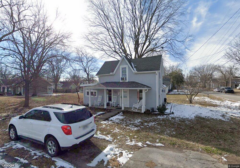
320 Siloam Place Siloam Springs, AR 72761
Estimated Value: $119,472 - $206,000
--
Bed
1
Bath
1,044
Sq Ft
$167/Sq Ft
Est. Value
About This Home
This home is located at 320 Siloam Place, Siloam Springs, AR 72761 and is currently estimated at $173,868, approximately $166 per square foot. 320 Siloam Place is a home located in Benton County with nearby schools including Northside Elementary School, Delbert Pete & Pat Allen Elementary School, and Southside Elementary School.
Ownership History
Date
Name
Owned For
Owner Type
Purchase Details
Closed on
Jan 8, 2002
Bought by
Winkler Tr
Current Estimated Value
Purchase Details
Closed on
May 24, 1999
Bought by
Winkler Tr
Purchase Details
Closed on
May 10, 1999
Bought by
Winkler Rev Trust
Purchase Details
Closed on
Aug 2, 1996
Bought by
Winkler
Purchase Details
Closed on
Oct 15, 1993
Bought by
Marshall
Purchase Details
Closed on
Dec 7, 1992
Bought by
Andrews
Create a Home Valuation Report for This Property
The Home Valuation Report is an in-depth analysis detailing your home's value as well as a comparison with similar homes in the area
Home Values in the Area
Average Home Value in this Area
Purchase History
| Date | Buyer | Sale Price | Title Company |
|---|---|---|---|
| Winkler Tr | -- | -- | |
| Winkler | -- | -- | |
| Winkler Tr | -- | -- | |
| Winkler Rev Trust | -- | -- | |
| Winkler | $38,000 | -- | |
| Marshall | -- | -- | |
| Andrews | $15,000 | -- |
Source: Public Records
Tax History Compared to Growth
Tax History
| Year | Tax Paid | Tax Assessment Tax Assessment Total Assessment is a certain percentage of the fair market value that is determined by local assessors to be the total taxable value of land and additions on the property. | Land | Improvement |
|---|---|---|---|---|
| 2025 | $405 | $20,768 | $7,400 | $13,368 |
| 2024 | $416 | $20,768 | $7,400 | $13,368 |
| 2023 | $416 | $12,270 | $5,600 | $6,670 |
| 2022 | $41 | $12,270 | $5,600 | $6,670 |
| 2021 | $40 | $12,270 | $5,600 | $6,670 |
| 2020 | $41 | $10,470 | $5,600 | $4,870 |
| 2019 | $41 | $10,470 | $5,600 | $4,870 |
| 2018 | $66 | $10,470 | $5,600 | $4,870 |
| 2017 | $66 | $10,470 | $5,600 | $4,870 |
| 2016 | $66 | $10,470 | $5,600 | $4,870 |
| 2015 | $416 | $7,220 | $1,600 | $5,620 |
| 2014 | $66 | $7,220 | $1,600 | $5,620 |
Source: Public Records
Map
Nearby Homes
- 0 Tbd St Andrews
- 506 E Ashley St
- 403 E University St
- 414 N Maxwell St
- 210 E Ashley St
- 517 N Madison St
- 101 E Central St
- 503 N Wright St
- 605 N Wright St
- 110 N Gunter St
- 716 N Mount Olive St
- 411 N Maple St
- 114 S College St
- 607 E Delaware St
- 111 E Helena St
- 908 Willow Ct
- TBD South N Elm St
- 0000 N Elm St
- 1.94 AC Lot 2 S Britt St
- 4.94 AC Lots 1 & 2 S Britt St
- 321 N Madison St
- 311 N Madison St
- 421 & 423 E Benton St
- 421 E Benton St
- 0 Lots 1-18 Blk Unit 1313074
- 0 Tbd Unit 1313074
- 306 Siloam Place
- 321 Siloam Place
- 403 N Madison St
- 315 Siloam Place
- 309 N Madison St
- 409 E Ashley St
- 403 Siloam Place
- 303 N Madison St
- 305 Siloam Place
- 410 Siloam Place
- 0 S 59 Hwy Unit 565818
- 0 S 59 Hwy Unit 665786
- 0 S 59 Hwy Unit 693029
- 0 S 59 Hwy Unit 1104592