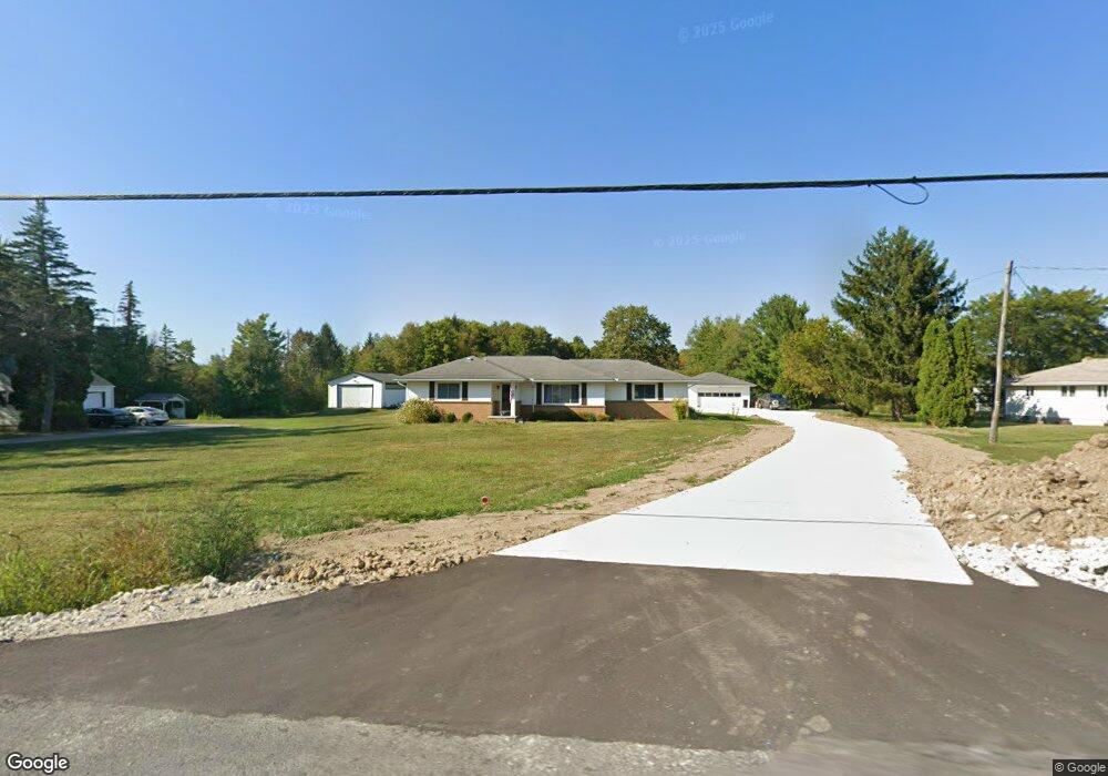
3201 State Route 82 Mantua, OH 44255
Estimated Value: $217,000 - $289,000
3
Beds
2
Baths
1,830
Sq Ft
$138/Sq Ft
Est. Value
About This Home
This home is located at 3201 State Route 82, Mantua, OH 44255 and is currently estimated at $253,451, approximately $138 per square foot. 3201 State Route 82 is a home located in Portage County with nearby schools including Crestwood Primary School, Crestwood Intermediate School, and Crestwood Middle School.
Ownership History
Date
Name
Owned For
Owner Type
Purchase Details
Closed on
Jan 28, 2020
Sold by
Gadomski Diane C and Gadomski Diane
Bought by
Gadomski William D
Current Estimated Value
Purchase Details
Closed on
Aug 15, 2017
Sold by
Dragich George
Bought by
Gadomski Diane
Purchase Details
Closed on
Aug 12, 2009
Sold by
Estate Of Marilyn Rae Dragich
Bought by
Gadomski Diane and Dragich George
Purchase Details
Closed on
Jan 1, 1990
Bought by
Dragich George N
Create a Home Valuation Report for This Property
The Home Valuation Report is an in-depth analysis detailing your home's value as well as a comparison with similar homes in the area
Home Values in the Area
Average Home Value in this Area
Purchase History
| Date | Buyer | Sale Price | Title Company |
|---|---|---|---|
| Gadomski William D | -- | None Available | |
| Gadomski Diane | -- | None Available | |
| Gadomski Diane | -- | None Available | |
| Dragich George N | -- | -- |
Source: Public Records
Tax History Compared to Growth
Tax History
| Year | Tax Paid | Tax Assessment Tax Assessment Total Assessment is a certain percentage of the fair market value that is determined by local assessors to be the total taxable value of land and additions on the property. | Land | Improvement |
|---|---|---|---|---|
| 2024 | $3,529 | $89,220 | $19,880 | $69,340 |
| 2023 | $2,855 | $65,320 | $18,450 | $46,870 |
| 2022 | $2,886 | $65,320 | $18,450 | $46,870 |
| 2021 | $2,904 | $65,320 | $18,450 | $46,870 |
| 2020 | $2,729 | $56,950 | $17,570 | $39,380 |
| 2019 | $2,695 | $56,950 | $17,570 | $39,380 |
| 2018 | $2,466 | $50,510 | $16,910 | $33,600 |
| 2017 | $2,466 | $50,510 | $16,910 | $33,600 |
| 2016 | $2,432 | $50,510 | $16,910 | $33,600 |
| 2015 | $2,548 | $50,510 | $16,910 | $33,600 |
| 2014 | $2,475 | $48,620 | $16,910 | $31,710 |
| 2013 | $2,399 | $48,620 | $16,910 | $31,710 |
Source: Public Records
Map
Nearby Homes
- 12298 Chamberlain Rd
- 200 Greentree Cir
- 11166 Loris Ave
- 290 Townline Rd
- 12167 Mantua Center Rd
- 483 Townline Rd
- 3444 Winchell Rd
- 679 Deep Woods Dr
- 12845 Vincent Dr
- 11470 Bowen Rd
- 1130 Winchell Rd
- 4364 Pioneer Trail
- 10389 Wentworth Rd
- 651 Parker Rd
- 0 Infirmary Rd
- 2785 Fairfax St
- 990 Whisperwood Ln
- 10306 Winthrop Rd
- 2653 Fairfax St
- 11131 State Route 44
- 3185 State Route 82
- 3217 State Route 82
- 3174 Ohio 82
- 3174 Ohio 82
- 3251 State Route 82
- 3149 State Route 82
- 3122 State Route 82 Unit 31
- 3122 Ohio 82
- 3218 State Route 82 Unit 178
- 3218 State Route 82 Unit 260
- 3218 State Route 82 Unit 208
- 3218 State Route 82
- 3218 State Route 82
- 3218 State Route 82 Unit 54
- 3273 State Route 82
- 3218 Ohio 82 Unit Lot 234
- 3218 Ohio 82 Unit 54
- 3218 Ohio 82 Unit 116 D
- 3218 Ohio 82
- 3299 State Route 82