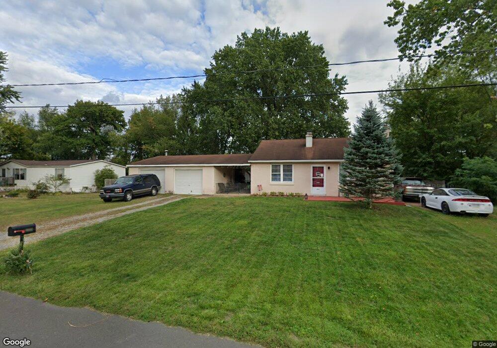
3209 Moore Ave Bensalem, PA 19020
Estimated Value: $298,000 - $361,000
3
Beds
1
Bath
896
Sq Ft
$376/Sq Ft
Est. Value
About This Home
This home is located at 3209 Moore Ave, Bensalem, PA 19020 and is currently estimated at $336,547, approximately $375 per square foot. 3209 Moore Ave is a home located in Bucks County with nearby schools including Robert K. Shafer Middle School, School Lane Charter School, and St Charles Borromeo School.
Ownership History
Date
Name
Owned For
Owner Type
Purchase Details
Closed on
May 14, 1998
Sold by
Rothenbach George J
Bought by
Bennett William F and Bennett Beverly J
Current Estimated Value
Home Financials for this Owner
Home Financials are based on the most recent Mortgage that was taken out on this home.
Original Mortgage
$66,000
Outstanding Balance
$12,817
Interest Rate
7.03%
Estimated Equity
$323,730
Purchase Details
Closed on
Dec 3, 1996
Sold by
Rothenbach George J and Rothenbach Charles Robert
Bought by
Rothenbach George J
Create a Home Valuation Report for This Property
The Home Valuation Report is an in-depth analysis detailing your home's value as well as a comparison with similar homes in the area
Home Values in the Area
Average Home Value in this Area
Purchase History
| Date | Buyer | Sale Price | Title Company |
|---|---|---|---|
| Bennett William F | $95,000 | -- | |
| Rothenbach George J | -- | -- |
Source: Public Records
Mortgage History
| Date | Status | Borrower | Loan Amount |
|---|---|---|---|
| Open | Bennett William F | $66,000 |
Source: Public Records
Tax History Compared to Growth
Tax History
| Year | Tax Paid | Tax Assessment Tax Assessment Total Assessment is a certain percentage of the fair market value that is determined by local assessors to be the total taxable value of land and additions on the property. | Land | Improvement |
|---|---|---|---|---|
| 2025 | $3,755 | $17,200 | $4,000 | $13,200 |
| 2024 | $3,755 | $17,200 | $4,000 | $13,200 |
| 2023 | $3,649 | $17,200 | $4,000 | $13,200 |
| 2022 | $3,627 | $17,200 | $4,000 | $13,200 |
| 2021 | $3,627 | $17,200 | $4,000 | $13,200 |
| 2020 | $3,591 | $17,200 | $4,000 | $13,200 |
| 2019 | $3,511 | $17,200 | $4,000 | $13,200 |
| 2018 | $3,430 | $17,200 | $4,000 | $13,200 |
| 2017 | $3,408 | $17,200 | $4,000 | $13,200 |
| 2016 | $3,408 | $17,200 | $4,000 | $13,200 |
| 2015 | -- | $17,200 | $4,000 | $13,200 |
| 2014 | -- | $17,200 | $4,000 | $13,200 |
Source: Public Records
Map
Nearby Homes
- 1164 William Penn Dr
- 3546 Bristol Pike
- 3552 Bristol Pike
- 3806 Bristol Pike
- 3933 Wrexham Ct
- 2498 Ogden Ave
- 119B Annapolis St
- 3967 Gloucester Ct
- 204A Dock St
- 116B King St
- 114B King St
- 104B King St
- 1105 Sheffield Ct
- 97 Waterside Mews
- 124 Cooper St
- 136b Alexandria St
- 211 Broad St
- 0 Neshaminy St Unit PABU2089046
- 2387 Forrest Ave
- 1319 Rosalie Ave