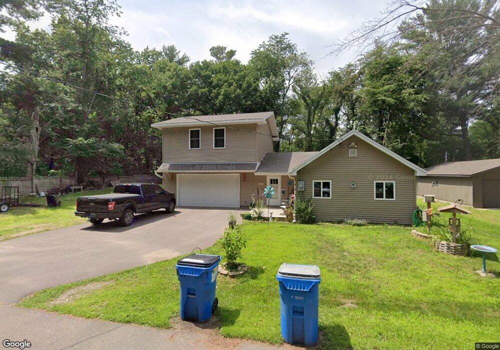
321 Cedar Rd Wyoming, MN 55092
Estimated Value: $304,000 - $364,000
2
Beds
1
Bath
1,728
Sq Ft
$193/Sq Ft
Est. Value
About This Home
This home is located at 321 Cedar Rd, Wyoming, MN 55092 and is currently estimated at $334,336, approximately $193 per square foot. 321 Cedar Rd is a home located in Anoka County with nearby schools including Linwood Elementary School and Forest Lake Area High School.
Ownership History
Date
Name
Owned For
Owner Type
Purchase Details
Closed on
Aug 17, 2018
Sold by
Lenzmeier Ronald J
Bought by
Mahan Kari
Current Estimated Value
Home Financials for this Owner
Home Financials are based on the most recent Mortgage that was taken out on this home.
Original Mortgage
$161,519
Outstanding Balance
$140,273
Interest Rate
4.5%
Mortgage Type
Stand Alone First
Estimated Equity
$194,063
Purchase Details
Closed on
Mar 25, 2009
Sold by
Wells Fargo Bank Na
Bought by
Lenzmerer Ronald J
Create a Home Valuation Report for This Property
The Home Valuation Report is an in-depth analysis detailing your home's value as well as a comparison with similar homes in the area
Home Values in the Area
Average Home Value in this Area
Purchase History
| Date | Buyer | Sale Price | Title Company |
|---|---|---|---|
| Mahan Kari | $164,500 | Title Smart Inc | |
| Lenzmerer Ronald J | $33,000 | -- |
Source: Public Records
Mortgage History
| Date | Status | Borrower | Loan Amount |
|---|---|---|---|
| Open | Mahan Kari | $161,519 | |
| Closed | Mahan Kari | $161,519 |
Source: Public Records
Tax History Compared to Growth
Tax History
| Year | Tax Paid | Tax Assessment Tax Assessment Total Assessment is a certain percentage of the fair market value that is determined by local assessors to be the total taxable value of land and additions on the property. | Land | Improvement |
|---|---|---|---|---|
| 2025 | $3,141 | $331,800 | $77,000 | $254,800 |
| 2024 | $3,141 | $325,600 | $75,500 | $250,100 |
| 2023 | $2,881 | $311,700 | $60,900 | $250,800 |
| 2022 | $1,526 | $313,000 | $53,500 | $259,500 |
| 2021 | $1,684 | $157,100 | $52,900 | $104,200 |
| 2020 | $1,592 | $163,000 | $64,800 | $98,200 |
| 2019 | $1,311 | $149,500 | $51,600 | $97,900 |
| 2018 | $1,578 | $122,800 | $0 | $0 |
| 2017 | $1,576 | $130,200 | $0 | $0 |
| 2016 | $1,312 | $95,900 | $0 | $0 |
| 2015 | -- | $95,900 | $25,300 | $70,600 |
| 2014 | -- | $88,000 | $29,000 | $59,000 |
Source: Public Records
Map
Nearby Homes
- xxx Birch Rd
- 426 Birch Rd
- 4310 Channel Ln NE
- 3841 Interlachen Dr NE
- 3837 Interlachen Dr NE
- 19479 Leyte St NE
- 3524 Interlachen Dr NE
- 3461 Interlachen Dr NE
- 3413 Interlachen Dr NE
- 4764 Lexington Ave NE
- 17307 Hiawatha Beach Dr NE
- 17327 Hiawatha Beach Dr NE
- 20136 Erskine St NE
- 17742 Oakland Dr NE
- 3464 172nd Ln NE
- TBD S 179th Ave NE
- 5160 202nd Ln NE
- 18216 Yancy St NE
- 3309 171st Ave NE
- xxxx Alamo St