Estimated Value: $148,000 - $165,000
3
Beds
1
Bath
1,316
Sq Ft
$117/Sq Ft
Est. Value
About This Home
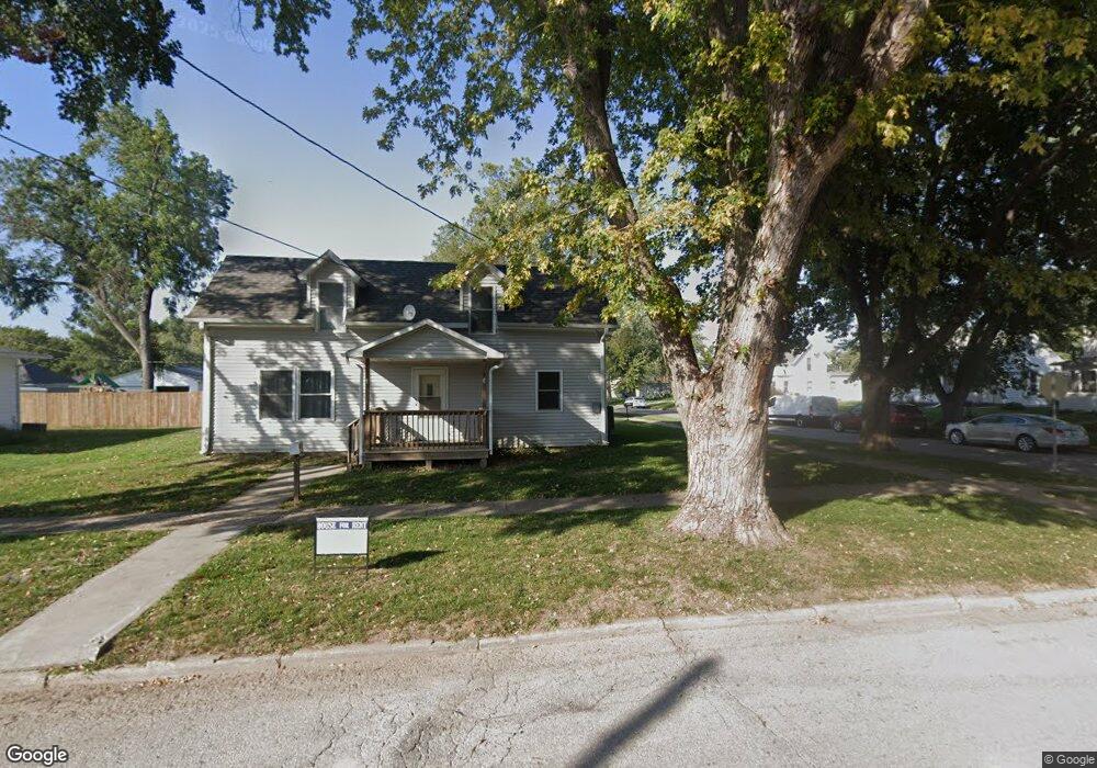
This home is located at 321 E 4th St, Logan, IA 51546 and is currently estimated at $154,333, approximately $117 per square foot. 321 E 4th St is a home located in Harrison County with nearby schools including Logan-Magnolia Elementary School and Logan-Magnolia Junior/Senior High School.
Ownership History
Date
Name
Owned For
Owner Type
Purchase Details
Closed on
Sep 20, 2023
Sold by
Cohrs Robert C and Cohrs Todd R
Bought by
Vandemark Randy S and Vandemark Lisa D
Current Estimated Value
Home Financials for this Owner
Home Financials are based on the most recent Mortgage that was taken out on this home.
Original Mortgage
$126,500
Outstanding Balance
$123,455
Interest Rate
6.96%
Mortgage Type
Credit Line Revolving
Estimated Equity
$30,878
Purchase Details
Closed on
Aug 16, 2023
Sold by
Todd R Cohrs And Lori K Cohrs Living Tru and Cohrs Todd R
Bought by
Cohrs Robert C
Home Financials for this Owner
Home Financials are based on the most recent Mortgage that was taken out on this home.
Original Mortgage
$126,500
Outstanding Balance
$123,455
Interest Rate
6.96%
Mortgage Type
Credit Line Revolving
Estimated Equity
$30,878
Create a Home Valuation Report for This Property
The Home Valuation Report is an in-depth analysis detailing your home's value as well as a comparison with similar homes in the area
Purchase History
| Date | Buyer | Sale Price | Title Company |
|---|---|---|---|
| Vandemark Randy S | $126,500 | Blair Abstract Title | |
| Cohrs Robert C | -- | None Listed On Document |
Source: Public Records
Mortgage History
| Date | Status | Borrower | Loan Amount |
|---|---|---|---|
| Open | Vandemark Randy S | $126,500 |
Source: Public Records
Tax History
| Year | Tax Paid | Tax Assessment Tax Assessment Total Assessment is a certain percentage of the fair market value that is determined by local assessors to be the total taxable value of land and additions on the property. | Land | Improvement |
|---|---|---|---|---|
| 2025 | $1,862 | $117,580 | $7,880 | $109,700 |
| 2024 | $1,862 | $105,930 | $7,880 | $98,050 |
| 2023 | $1,796 | $105,930 | $7,880 | $98,050 |
| 2022 | $1,524 | $78,150 | $7,875 | $70,275 |
| 2021 | $1,524 | $78,150 | $7,875 | $70,275 |
| 2020 | $1,204 | $72,327 | $7,875 | $64,452 |
| 2019 | $986 | $72,327 | $7,875 | $64,452 |
| 2018 | $960 | $62,655 | $0 | $0 |
| 2017 | $960 | $62,655 | $0 | $0 |
| 2016 | $1,006 | $62,655 | $0 | $0 |
| 2015 | $1,006 | $56,446 | $0 | $0 |
| 2014 | $850 | $56,446 | $0 | $0 |
Source: Public Records
Map
Nearby Homes
- 217 N 2nd Ave
- 114 E 10th St
- 1010 Skyline Dr
- Lot 18 Mulligan Trail
- 2144 Norton Ave
- LOT 27 Mulligan Trail
- LOT 26 Lmvcc Estates
- 2464 Mulligan Trail
- LOT 20 Lmvcc Estates
- LOT 17 Lmvcc Estates
- LOT 15 Mulligan Trail
- 2853 Preston Place
- 0 Preston Place
- 0 Preston Place 2 Parcels
- LOTS 5 & 6 Fieldcrest Dr
- LOT D Fieldcrest Dr
- LOT 9 & 10 Fieldcrest Dr
- LOT E & K Fieldcrest Dr
- LOT C Fieldcrest Dr
- LOTS 7 & 8 Fieldcrest Dr
Your Personal Tour Guide
Ask me questions while you tour the home.