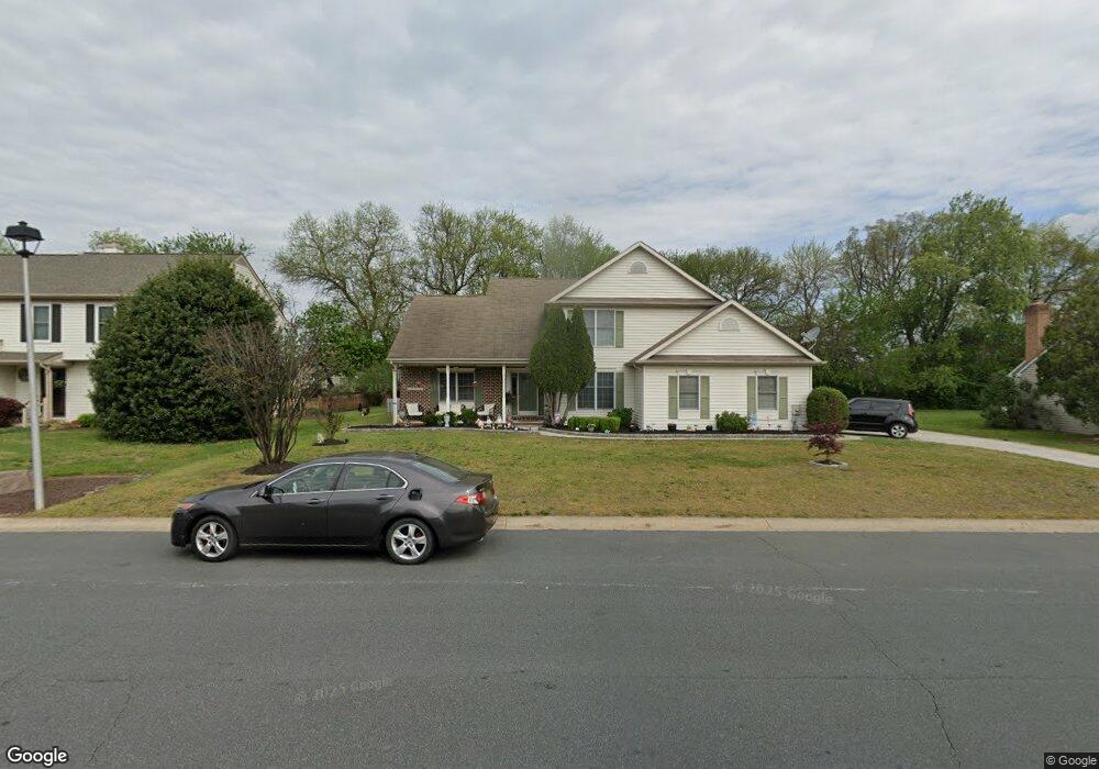
321 Eagle Nest Dr Camden Wyoming, DE 19934
Estimated Value: $423,000 - $458,000
4
Beds
3
Baths
2,479
Sq Ft
$177/Sq Ft
Est. Value
About This Home
This home is located at 321 Eagle Nest Dr, Camden Wyoming, DE 19934 and is currently estimated at $439,097, approximately $177 per square foot. 321 Eagle Nest Dr is a home located in Kent County with nearby schools including Allen Frear Elementary School, F. Niel Postlethwait Middle School, and Caesar Rodney High School.
Ownership History
Date
Name
Owned For
Owner Type
Purchase Details
Closed on
Jul 12, 2006
Sold by
Santore David W and Santore Laura A
Bought by
Leach John F and Leach Laura M
Current Estimated Value
Home Financials for this Owner
Home Financials are based on the most recent Mortgage that was taken out on this home.
Original Mortgage
$272,650
Outstanding Balance
$162,044
Interest Rate
6.67%
Mortgage Type
Future Advance Clause Open End Mortgage
Estimated Equity
$277,053
Create a Home Valuation Report for This Property
The Home Valuation Report is an in-depth analysis detailing your home's value as well as a comparison with similar homes in the area
Home Values in the Area
Average Home Value in this Area
Purchase History
| Date | Buyer | Sale Price | Title Company |
|---|---|---|---|
| Leach John F | $8,610 | None Available |
Source: Public Records
Mortgage History
| Date | Status | Borrower | Loan Amount |
|---|---|---|---|
| Open | Leach John F | $272,650 |
Source: Public Records
Tax History Compared to Growth
Tax History
| Year | Tax Paid | Tax Assessment Tax Assessment Total Assessment is a certain percentage of the fair market value that is determined by local assessors to be the total taxable value of land and additions on the property. | Land | Improvement |
|---|---|---|---|---|
| 2025 | $1,961 | $370,500 | $94,500 | $276,000 |
| 2024 | $1,961 | $370,500 | $94,500 | $276,000 |
| 2023 | $2,256 | $69,600 | $11,600 | $58,000 |
| 2022 | $2,138 | $69,600 | $11,600 | $58,000 |
| 2021 | $2,115 | $69,600 | $11,600 | $58,000 |
| 2020 | $2,071 | $69,600 | $11,600 | $58,000 |
| 2019 | $2,006 | $69,600 | $11,600 | $58,000 |
| 2018 | $1,950 | $69,600 | $11,600 | $58,000 |
| 2017 | $1,920 | $70,200 | $0 | $0 |
| 2016 | $1,833 | $70,200 | $0 | $0 |
| 2015 | $1,592 | $70,200 | $0 | $0 |
| 2014 | $1,583 | $70,200 | $0 | $0 |
Source: Public Records
Map
Nearby Homes
- 215 Sandy Hill Trail
- 80 N High Hill Rd
- 102 Gardengate Rd
- 45 Brookfield Dr
- 42 Brookfield Dr
- 5 Drew Ct
- 83 Homestead Dr
- 256 Headstart Ln
- 464 Orchard Grove Dr
- 55 Orchard Grove Ct
- 0 First Tenth Ct
- 160 Humphreys Dr
- 4 King Henry Ct
- 552 S Old Mill Rd
- 19 S Main St
- 201 Homestead Dr
- 96 Pear Blossom Ln
- 54 E Fred Cir
- Garrett Plan at Brookfield
- Linden Plan at Brookfield
- 401 Eagle Nest Dr
- 319 Eagle Nest Dr
- 774 Sandy Hill Trail
- 756 Sandy Hill Trail
- 403 Eagle Nest Dr
- 320 Eagle Nest Dr
- 738 Sandy Hill Trail
- 317 Eagle Nest Dr
- 400 Eagle Nest Dr
- 316 Eagle Nest Dr
- 812 Sandy Hill Trail
- 405 Eagle Nest Dr
- 791 Sandy Hill Trail
- 775 Sandy Hill Trail
- 718 Sandy Hill Trail
- 755 Sandy Hill Trail
- 302 Falcon Dr
- 404 Eagle Nest Dr
- 315 Eagle Nest Dr
- 314 Eagle Nest Dr