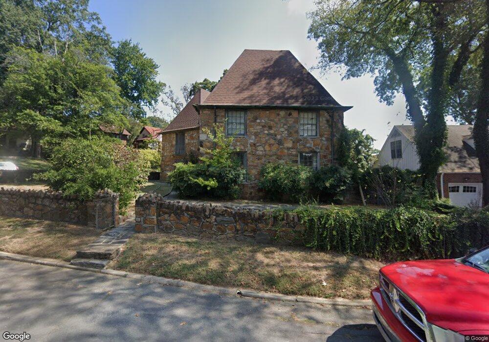
321 Linwood Ct Little Rock, AR 72205
Hillcrest NeighborhoodEstimated Value: $622,000 - $753,000
--
Bed
2
Baths
3,543
Sq Ft
$192/Sq Ft
Est. Value
About This Home
This home is located at 321 Linwood Ct, Little Rock, AR 72205 and is currently estimated at $679,357, approximately $191 per square foot. 321 Linwood Ct is a home located in Pulaski County with nearby schools including Pulaski Heights Elementary School, Pulaski Heights Middle School, and Central High School.
Ownership History
Date
Name
Owned For
Owner Type
Purchase Details
Closed on
Dec 30, 2005
Sold by
Allen Donald V and Allen Mary Elaine
Bought by
Evans Harold J and Evans Kim H
Current Estimated Value
Home Financials for this Owner
Home Financials are based on the most recent Mortgage that was taken out on this home.
Original Mortgage
$500,000
Interest Rate
6.3%
Mortgage Type
Purchase Money Mortgage
Create a Home Valuation Report for This Property
The Home Valuation Report is an in-depth analysis detailing your home's value as well as a comparison with similar homes in the area
Home Values in the Area
Average Home Value in this Area
Purchase History
| Date | Buyer | Sale Price | Title Company |
|---|---|---|---|
| Evans Harold J | $475,000 | -- |
Source: Public Records
Mortgage History
| Date | Status | Borrower | Loan Amount |
|---|---|---|---|
| Closed | Evans Harold J | $500,000 |
Source: Public Records
Tax History Compared to Growth
Tax History
| Year | Tax Paid | Tax Assessment Tax Assessment Total Assessment is a certain percentage of the fair market value that is determined by local assessors to be the total taxable value of land and additions on the property. | Land | Improvement |
|---|---|---|---|---|
| 2025 | $5,555 | $104,255 | $37,500 | $66,755 |
| 2024 | $5,555 | $104,255 | $37,500 | $66,755 |
| 2023 | $5,555 | $104,255 | $37,500 | $66,755 |
| 2022 | $6,931 | $104,255 | $37,500 | $66,755 |
| 2021 | $6,648 | $94,300 | $34,950 | $59,350 |
| 2020 | $5,973 | $94,300 | $34,950 | $59,350 |
| 2019 | $5,709 | $94,300 | $34,950 | $59,350 |
| 2018 | $5,469 | $94,300 | $34,950 | $59,350 |
| 2017 | $5,205 | $94,300 | $34,950 | $59,350 |
| 2016 | $5,290 | $75,570 | $12,300 | $63,270 |
| 2015 | $5,297 | $75,570 | $12,300 | $63,270 |
| 2014 | $5,297 | $75,570 | $12,300 | $63,270 |
Source: Public Records
Map
Nearby Homes
- 516 N Oak St
- 518 N Oak St
- 206 Linwood Ct
- 3409 Hill Rd
- 621 N Pine St
- 118 N Pine St
- 110 N Cedar St
- 220 S Valentine St
- 921 Midland St
- 203 Midland St
- 4119 Lee Ave
- 312 Valmar St
- 102 Midland St
- 1109 Kavanaugh Blvd
- 111 Midland St
- 310 S Oak St
- 3612 Oakwood Rd
- 1116 Kavanaugh Blvd
- 3901 Cedar Hill #23 Rd
- 3901 Cedar Hill Rd
- 321 Linwood Ct
- 315 Linwood Ct
- 321 Crystal Ct
- 333 Crystal Ct
- 305 Linwood Ct
- 220 Crystal Ct
- 335 Crystal Ct
- 318 Linwood Ct
- 301 Linwood Ct
- 0 Linwood Ct Unit 15026713
- 0 Linwood Ct Unit 16007737
- 0 Linwood Ct Unit 16008385
- 0 Linwood Ct Unit 17033758
- 0 Linwood Ct Unit 20033969
- 0 Linwood Ct Unit 20038212
- 339 Crystal Ct
- 218 Crystal Ct
- 310 Linwood Ct
- 340 Crystal Ct
- 311 Crystal Ct