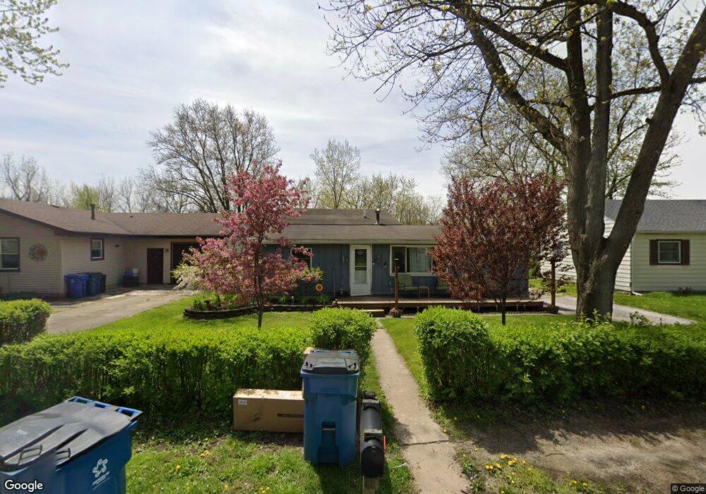
321 Maple St Crown Point, IN 46307
Estimated Value: $210,000 - $309,000
5
Beds
2
Baths
1,977
Sq Ft
$137/Sq Ft
Est. Value
About This Home
This home is located at 321 Maple St, Crown Point, IN 46307 and is currently estimated at $270,449, approximately $136 per square foot. 321 Maple St is a home located in Lake County with nearby schools including Timothy Ball Elementary School, Robert Taft Middle School, and Crown Point High School.
Ownership History
Date
Name
Owned For
Owner Type
Purchase Details
Closed on
Oct 27, 2008
Sold by
Vellines Judith L
Bought by
Neely Maude F
Current Estimated Value
Home Financials for this Owner
Home Financials are based on the most recent Mortgage that was taken out on this home.
Original Mortgage
$82,300
Outstanding Balance
$53,202
Interest Rate
6.11%
Mortgage Type
Purchase Money Mortgage
Estimated Equity
$217,247
Create a Home Valuation Report for This Property
The Home Valuation Report is an in-depth analysis detailing your home's value as well as a comparison with similar homes in the area
Home Values in the Area
Average Home Value in this Area
Purchase History
| Date | Buyer | Sale Price | Title Company |
|---|---|---|---|
| Neely Maude F | -- | Community Title Company |
Source: Public Records
Mortgage History
| Date | Status | Borrower | Loan Amount |
|---|---|---|---|
| Open | Neely Maude F | $82,300 |
Source: Public Records
Tax History
| Year | Tax Paid | Tax Assessment Tax Assessment Total Assessment is a certain percentage of the fair market value that is determined by local assessors to be the total taxable value of land and additions on the property. | Land | Improvement |
|---|---|---|---|---|
| 2025 | $4,330 | $226,000 | $24,400 | $201,600 |
| 2024 | $5,337 | $206,900 | $24,400 | $182,500 |
| 2023 | $4,081 | $194,200 | $24,400 | $169,800 |
| 2022 | $4,081 | $184,600 | $24,400 | $160,200 |
| 2021 | $3,844 | $173,900 | $20,200 | $153,700 |
| 2020 | $3,720 | $168,300 | $20,200 | $148,100 |
| 2019 | $3,653 | $163,200 | $20,200 | $143,000 |
| 2018 | $4,041 | $156,800 | $20,200 | $136,600 |
| 2017 | $4,101 | $157,200 | $20,200 | $137,000 |
| 2016 | $4,028 | $151,700 | $20,200 | $131,500 |
| 2014 | $3,735 | $150,300 | $20,200 | $130,100 |
| 2013 | $3,458 | $137,500 | $20,200 | $117,300 |
Source: Public Records
Map
Nearby Homes
- 324 Maple St
- 316 Oak Cir
- 350 Cochran Dr
- 1436 Bohling Place
- 1465 Mybeck Place
- 11200 Oak Ridge Ct
- 772 Kenmare Pkwy
- 771 Kenmare Pkwy
- 767 Kenmare Pkwy
- 900 Easy St
- 511 N West St
- 1065 Easy St Unit C
- 301 Hoffman St
- 306 Holton Ridge
- 1718 Silver Hawk Dr
- 600 W North St
- 805 Veterans Ln
- 1845 W 99th Place
- 802 Veterans Ln
- 7770 W 106th Ln
Your Personal Tour Guide
Ask me questions while you tour the home.