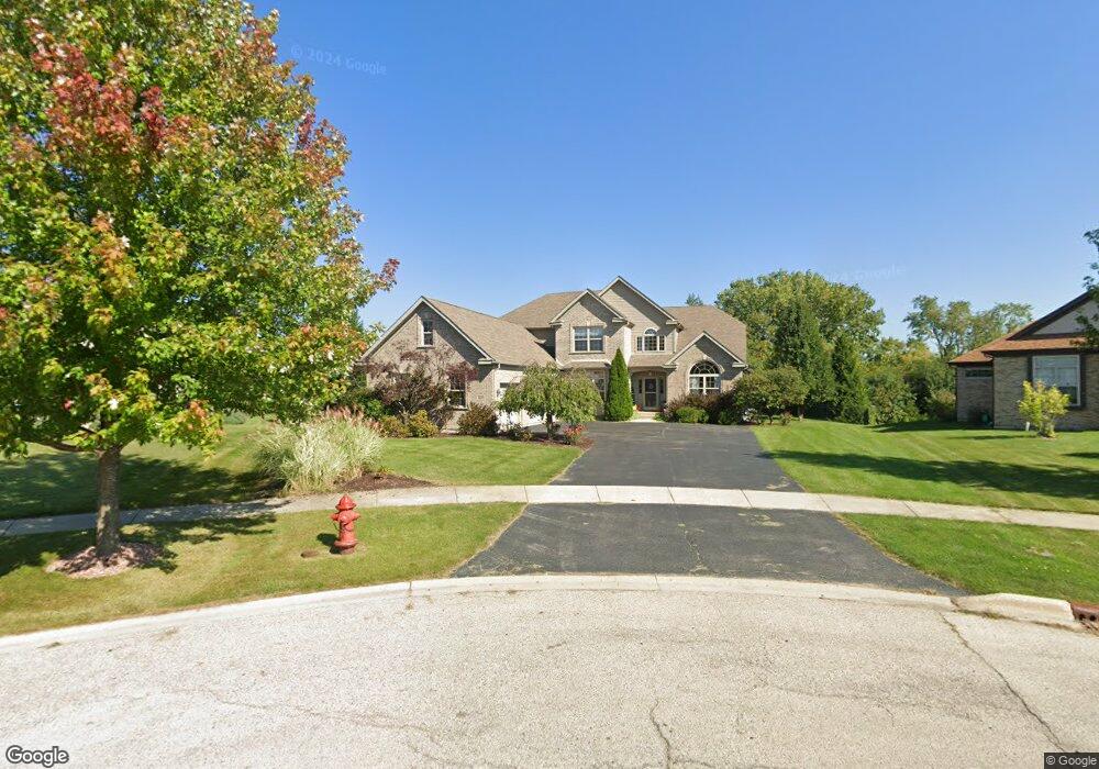
321 Rachel Ct Winthrop Harbor, IL 60096
Estimated Value: $495,301 - $513,000
4
Beds
6
Baths
3,254
Sq Ft
$154/Sq Ft
Est. Value
About This Home
This home is located at 321 Rachel Ct, Winthrop Harbor, IL 60096 and is currently estimated at $501,825, approximately $154 per square foot. 321 Rachel Ct is a home located in Lake County with nearby schools including Kenneth Murphy School, Beach Park Middle School, and Zion-Benton Township High School.
Ownership History
Date
Name
Owned For
Owner Type
Purchase Details
Closed on
Apr 27, 2007
Sold by
Norstates Bank
Bought by
Nommensen Ken E and Nommensen Sandra J
Current Estimated Value
Home Financials for this Owner
Home Financials are based on the most recent Mortgage that was taken out on this home.
Original Mortgage
$325,000
Interest Rate
6.2%
Mortgage Type
Purchase Money Mortgage
Create a Home Valuation Report for This Property
The Home Valuation Report is an in-depth analysis detailing your home's value as well as a comparison with similar homes in the area
Home Values in the Area
Average Home Value in this Area
Purchase History
| Date | Buyer | Sale Price | Title Company |
|---|---|---|---|
| Nommensen Ken E | $412,500 | None Available |
Source: Public Records
Mortgage History
| Date | Status | Borrower | Loan Amount |
|---|---|---|---|
| Previous Owner | Nommensen Ken E | $325,000 |
Source: Public Records
Tax History Compared to Growth
Tax History
| Year | Tax Paid | Tax Assessment Tax Assessment Total Assessment is a certain percentage of the fair market value that is determined by local assessors to be the total taxable value of land and additions on the property. | Land | Improvement |
|---|---|---|---|---|
| 2024 | $13,885 | $147,955 | $10,832 | $137,123 |
| 2023 | $13,187 | $137,546 | $10,457 | $127,089 |
| 2022 | $13,187 | $126,498 | $10,244 | $116,254 |
| 2021 | $13,512 | $123,280 | $9,983 | $113,297 |
| 2020 | $13,126 | $117,645 | $9,527 | $108,118 |
| 2019 | $12,824 | $111,618 | $9,039 | $102,579 |
| 2018 | $12,530 | $108,543 | $10,966 | $97,577 |
| 2017 | $12,450 | $102,110 | $10,316 | $91,794 |
| 2016 | $12,150 | $97,211 | $9,821 | $87,390 |
| 2015 | $11,979 | $89,152 | $9,007 | $80,145 |
| 2014 | $11,351 | $88,092 | $25,134 | $62,958 |
| 2012 | $11,122 | $91,544 | $26,119 | $65,425 |
Source: Public Records
Map
Nearby Homes
- 429 Megan Place
- 432 Megan Place
- 436 Megan Place
- 11279 W Russell Rd
- 43100 N Lewis Ave
- 42908 N Lewis Ave
- 0 Garnett Ave
- Lt0 128th St
- 242 Thompson Ave
- 210 Oak Ln
- Lt0 39th Ave
- 12122 28th Ave
- 12111 28th Ave
- 3109 11th St
- 830 Russell Ave
- 1810 5th St
- 630 Whitney Ave
- 3106 13th St
- 1228 Pennsylvania Ave
- 0 13th St Unit MRD12432014