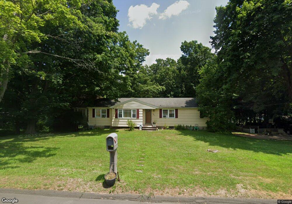
321 Shepard Ave Hamden, CT 06514
Estimated Value: $317,000 - $415,000
3
Beds
2
Baths
1,420
Sq Ft
$257/Sq Ft
Est. Value
About This Home
This home is located at 321 Shepard Ave, Hamden, CT 06514 and is currently estimated at $365,486, approximately $257 per square foot. 321 Shepard Ave is a home located in New Haven County with nearby schools including Hamden Middle School, Hamden High School, and Alphabet Academy - Hamden North Campus.
Ownership History
Date
Name
Owned For
Owner Type
Purchase Details
Closed on
Aug 4, 2014
Sold by
Buontempo Antonio and Buontempo Vincenzo
Bought by
321 Shepard Ave Llc
Current Estimated Value
Purchase Details
Closed on
Mar 23, 2012
Sold by
Baglioni Alice J
Bought by
Buontempo Antonio and Buontempo Vincenzo
Home Financials for this Owner
Home Financials are based on the most recent Mortgage that was taken out on this home.
Original Mortgage
$120,000
Interest Rate
3.86%
Create a Home Valuation Report for This Property
The Home Valuation Report is an in-depth analysis detailing your home's value as well as a comparison with similar homes in the area
Home Values in the Area
Average Home Value in this Area
Purchase History
| Date | Buyer | Sale Price | Title Company |
|---|---|---|---|
| 321 Shepard Ave Llc | -- | -- | |
| Buontempo Antonio | $120,000 | -- |
Source: Public Records
Mortgage History
| Date | Status | Borrower | Loan Amount |
|---|---|---|---|
| Previous Owner | Buontempo Antonio | $120,000 | |
| Previous Owner | Buontempo Antonio | $5,000 |
Source: Public Records
Tax History
| Year | Tax Paid | Tax Assessment Tax Assessment Total Assessment is a certain percentage of the fair market value that is determined by local assessors to be the total taxable value of land and additions on the property. | Land | Improvement |
|---|---|---|---|---|
| 2025 | $10,339 | $199,290 | $61,670 | $137,620 |
| 2024 | $7,637 | $137,340 | $43,190 | $94,150 |
| 2023 | $7,743 | $137,340 | $43,190 | $94,150 |
| 2022 | $7,620 | $137,340 | $43,190 | $94,150 |
| 2021 | $7,202 | $137,340 | $43,190 | $94,150 |
| 2020 | $7,357 | $141,540 | $75,250 | $66,290 |
| 2019 | $6,916 | $141,540 | $75,250 | $66,290 |
| 2018 | $6,788 | $141,540 | $75,250 | $66,290 |
| 2017 | $6,406 | $141,540 | $75,250 | $66,290 |
| 2016 | $6,420 | $141,540 | $75,250 | $66,290 |
| 2015 | $6,563 | $160,580 | $83,650 | $76,930 |
| 2014 | $6,412 | $160,580 | $83,650 | $76,930 |
Source: Public Records
Map
Nearby Homes
- 900 Mix Ave Unit 69
- 900 Mix Ave Unit 123
- 175 Mill Pond Rd Unit 106
- 136 Shepard Ave Unit 136
- 5 Shepard Hill Rd
- 114 Colony St
- 172 Towne House Rd
- 150 Towne House Rd Unit 150
- 37 Towne House Rd
- 32 Towne House Rd Unit 32
- 4 Raccio Park Rd
- 147 Centerbrook Rd
- 93 Centerbrook Rd
- 25 Hamden Hills Dr Unit 69
- 2831 Dixwell Ave
- 51 Evergreen Ave
- 248 Centerbrook Rd
- 707 Mix Ave Unit 38
- 240 Centerbrook Rd Unit 240
- 141 Worth Ave
- 241 Braeside Dr
- 343 Shepard Ave
- 305 Shepard Ave
- 330 Shepard Ave
- 253 Braeside Dr
- 320 Shepard Ave
- 346 Shepard Ave
- 229 Braeside Dr
- 314 Shepard Ave
- 355 Shepard Ave
- 289 Shepard Ave
- 354 Shepard Ave
- 217 Braeside Dr
- 261 Braeside Dr
- 306 Shepard Ave
- 85 Rentell Rd
- 77 Rentell Rd
- 93 Rentell Rd
- 279 Shepard Ave
- 105 Rentell Rd
Your Personal Tour Guide
Ask me questions while you tour the home.