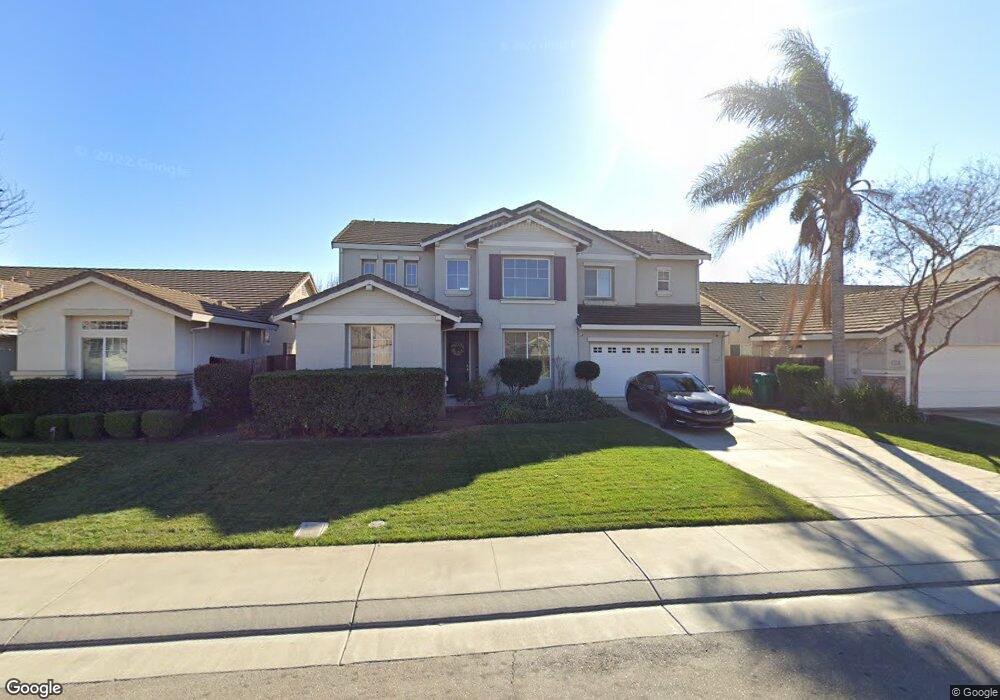
3210 Bryant Dr Stockton, CA 95212
Valley Oak NeighborhoodEstimated Value: $194,000 - $589,000
5
Beds
4
Baths
2,585
Sq Ft
$186/Sq Ft
Est. Value
About This Home
This home is located at 3210 Bryant Dr, Stockton, CA 95212 and is currently estimated at $479,577, approximately $185 per square foot. 3210 Bryant Dr is a home located in San Joaquin County with nearby schools including Ansel Adams School, Morada Middle School, and Ronald E. McNair High School.
Ownership History
Date
Name
Owned For
Owner Type
Purchase Details
Closed on
Jul 8, 2011
Sold by
Reyes Evelyn
Bought by
Cheung Fong Yuen and Yue Stella S
Current Estimated Value
Purchase Details
Closed on
Jul 20, 2005
Sold by
Reyes Felmar
Bought by
Reyes Evelyn
Home Financials for this Owner
Home Financials are based on the most recent Mortgage that was taken out on this home.
Original Mortgage
$420,000
Interest Rate
6.37%
Mortgage Type
New Conventional
Purchase Details
Closed on
Oct 1, 2004
Sold by
Reyes Evelyn and Reyes Felmar
Bought by
Reyes Felmar and Reyes Evelyn
Home Financials for this Owner
Home Financials are based on the most recent Mortgage that was taken out on this home.
Original Mortgage
$360,000
Interest Rate
5.5%
Mortgage Type
New Conventional
Create a Home Valuation Report for This Property
The Home Valuation Report is an in-depth analysis detailing your home's value as well as a comparison with similar homes in the area
Home Values in the Area
Average Home Value in this Area
Purchase History
| Date | Buyer | Sale Price | Title Company |
|---|---|---|---|
| Cheung Fong Yuen | $190,000 | Chicago Title Company | |
| Reyes Evelyn | -- | Alliance Title Co | |
| Reyes Felmar | -- | Financial Title Co |
Source: Public Records
Mortgage History
| Date | Status | Borrower | Loan Amount |
|---|---|---|---|
| Previous Owner | Reyes Evelyn | $420,000 | |
| Previous Owner | Reyes Felmar | $360,000 |
Source: Public Records
Tax History Compared to Growth
Tax History
| Year | Tax Paid | Tax Assessment Tax Assessment Total Assessment is a certain percentage of the fair market value that is determined by local assessors to be the total taxable value of land and additions on the property. | Land | Improvement |
|---|---|---|---|---|
| 2025 | $3,358 | $238,641 | $59,030 | $179,611 |
| 2024 | $3,298 | $233,963 | $57,873 | $176,090 |
| 2023 | $3,244 | $229,377 | $56,739 | $172,638 |
| 2022 | $3,167 | $224,880 | $55,627 | $169,253 |
| 2021 | $3,208 | $220,472 | $54,537 | $165,935 |
| 2020 | $3,188 | $218,212 | $53,978 | $164,234 |
| 2019 | $3,081 | $213,934 | $52,920 | $161,014 |
| 2018 | $3,026 | $209,740 | $51,883 | $157,857 |
| 2017 | $2,936 | $205,628 | $50,866 | $154,762 |
| 2016 | $2,842 | $201,595 | $49,868 | $151,727 |
| 2014 | $2,811 | $194,680 | $48,158 | $146,522 |
Source: Public Records
Map
Nearby Homes
- 3484 Cathedral Cir
- 8061 Shay Cir
- 9253 Bridalveil Cir
- 8837 Fox Creek Dr Unit 1
- 8916 Fox Creek Dr
- 8904 Fox Creek Dr Unit 84
- 8169 Shay Cir
- 8007 Lorraine Ave
- 9308 Pioneer Cir
- 8517 Kenny Ct
- 9042 Chianti Cir
- 9332 Kirkby Ln
- 2619 Claridge Ln
- 9321 Kirkby Ln
- 2810 Auto Center Cir
- 7112 Tristan Cir
- 7127 Tristan Cir Unit 10
- 8107 8107 Grenoble Way
- 9314 Cherbourg Way
- 7849 Moreland St