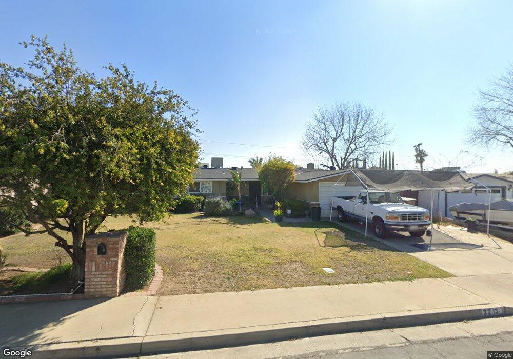
3213 Kaibab Ave Bakersfield, CA 93306
College Heights NeighborhoodEstimated Value: $303,099 - $366,000
4
Beds
2
Baths
1,666
Sq Ft
$200/Sq Ft
Est. Value
About This Home
This home is located at 3213 Kaibab Ave, Bakersfield, CA 93306 and is currently estimated at $334,025, approximately $200 per square foot. 3213 Kaibab Ave is a home located in Kern County with nearby schools including Colonel Howard Nichols Elementary School, Chipman Junior High School, and Highland High School.
Ownership History
Date
Name
Owned For
Owner Type
Purchase Details
Closed on
Jul 18, 2012
Sold by
Birdwell Mark and Birdwell Lupe
Bought by
Birdwell Mark and Birdwell Lupe
Current Estimated Value
Home Financials for this Owner
Home Financials are based on the most recent Mortgage that was taken out on this home.
Original Mortgage
$138,700
Interest Rate
3.63%
Mortgage Type
New Conventional
Create a Home Valuation Report for This Property
The Home Valuation Report is an in-depth analysis detailing your home's value as well as a comparison with similar homes in the area
Home Values in the Area
Average Home Value in this Area
Purchase History
| Date | Buyer | Sale Price | Title Company |
|---|---|---|---|
| Birdwell Mark | -- | Chicago Title Company |
Source: Public Records
Mortgage History
| Date | Status | Borrower | Loan Amount |
|---|---|---|---|
| Closed | Birdwell Mark | $138,700 |
Source: Public Records
Tax History Compared to Growth
Tax History
| Year | Tax Paid | Tax Assessment Tax Assessment Total Assessment is a certain percentage of the fair market value that is determined by local assessors to be the total taxable value of land and additions on the property. | Land | Improvement |
|---|---|---|---|---|
| 2025 | $2,336 | $148,336 | $35,121 | $113,215 |
| 2024 | $2,282 | $145,429 | $34,433 | $110,996 |
| 2023 | $2,282 | $142,578 | $33,758 | $108,820 |
| 2022 | $2,223 | $139,784 | $33,097 | $106,687 |
| 2021 | $2,114 | $137,045 | $32,449 | $104,596 |
| 2020 | $2,078 | $135,641 | $32,117 | $103,524 |
| 2019 | $2,035 | $135,641 | $32,117 | $103,524 |
| 2018 | $1,988 | $130,376 | $30,871 | $99,505 |
| 2017 | $1,975 | $127,820 | $30,266 | $97,554 |
| 2016 | $1,819 | $125,315 | $29,673 | $95,642 |
| 2015 | $1,805 | $123,434 | $29,228 | $94,206 |
| 2014 | $1,746 | $121,017 | $28,656 | $92,361 |
Source: Public Records
Map
Nearby Homes
- 3119 University Ave
- 3200 University Ave
- 3206 Candlewood Dr
- 2801 Kaibab Ave
- 3221 Colgate Ln
- 3613 Fleetwood Way
- 3618 Redlands Dr
- 3706 Rampart St
- 2818 San Pablo Ave
- 3609 Cardinal Ave
- 3413 Redlands Dr
- 2701 Kaibab Ave
- 2901 Dwight St
- 2700 University Ave
- 2913 Harmony Dr
- 3712 Harvard Dr
- 3818 Harvard Dr
- 2914 Roanoke Ct
- 3019 Christmas Tree Ln
- 3601 Harvard Dr
- 3219 Kaibab Ave
- 3207 Kaibab Ave
- 3212 Blade Ave
- 3218 Blade Ave
- 3206 Blade Ave
- 3301 Kaibab Ave
- 3201 Kaibab Ave
- 3218 Kaibab Ave
- 3212 Kaibab Ave
- 3300 Blade Ave
- 3224 Kaibab Ave
- 3200 Blade Ave
- 3206 Kaibab Ave
- 3307 Kaibab Ave
- 3300 Kaibab Ave
- 3306 Blade Ave
- 3200 Kaibab Ave
- 3213 Blade Ave
- 3219 Blade Ave
- 3207 Blade Ave