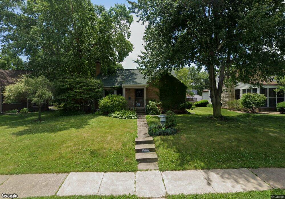
3223 Middle Rd Davenport, IA 52803
East End NeighborhoodEstimated Value: $258,000 - $312,000
2
Beds
4
Baths
2,226
Sq Ft
$128/Sq Ft
Est. Value
About This Home
This home is located at 3223 Middle Rd, Davenport, IA 52803 and is currently estimated at $285,048, approximately $128 per square foot. 3223 Middle Rd is a home located in Scott County with nearby schools including McKinley Elementary School, Sudlow Intermediate School, and Central High School.
Ownership History
Date
Name
Owned For
Owner Type
Purchase Details
Closed on
Jan 17, 2023
Sold by
Gere John E
Bought by
John E Gere Revocable Trust and Gere
Current Estimated Value
Purchase Details
Closed on
Dec 3, 2013
Sold by
Gere Perry
Bought by
Gere John E
Purchase Details
Closed on
Nov 15, 2013
Sold by
George Tom W
Bought by
Gere John E
Create a Home Valuation Report for This Property
The Home Valuation Report is an in-depth analysis detailing your home's value as well as a comparison with similar homes in the area
Home Values in the Area
Average Home Value in this Area
Purchase History
| Date | Buyer | Sale Price | Title Company |
|---|---|---|---|
| John E Gere Revocable Trust | -- | None Listed On Document | |
| Gere John E | -- | -- | |
| Gere John E | -- | None Available | |
| Gere John E | -- | None Available |
Source: Public Records
Tax History Compared to Growth
Tax History
| Year | Tax Paid | Tax Assessment Tax Assessment Total Assessment is a certain percentage of the fair market value that is determined by local assessors to be the total taxable value of land and additions on the property. | Land | Improvement |
|---|---|---|---|---|
| 2025 | $4,176 | $282,720 | $36,630 | $246,090 |
| 2024 | $4,070 | $243,860 | $36,630 | $207,230 |
| 2023 | $4,782 | $243,860 | $36,630 | $207,230 |
| 2022 | $4,636 | $232,800 | $33,440 | $199,360 |
| 2021 | $4,636 | $225,010 | $33,440 | $191,570 |
| 2020 | $4,392 | $211,000 | $33,440 | $177,560 |
| 2019 | $4,544 | $211,000 | $33,440 | $177,560 |
| 2018 | $4,374 | $211,000 | $33,440 | $177,560 |
| 2017 | $1,156 | $207,890 | $33,440 | $174,450 |
| 2016 | $4,124 | $196,990 | $0 | $0 |
| 2015 | $4,124 | $182,930 | $0 | $0 |
| 2014 | $3,870 | $182,930 | $0 | $0 |
| 2013 | $3,798 | $0 | $0 | $0 |
| 2012 | -- | $186,240 | $49,280 | $136,960 |
Source: Public Records
Map
Nearby Homes
- 1708 Eastmere Dr
- 3418 Middle Rd
- 3019 E 18th St
- 3009 E 18th St
- 1360 Heights Ct
- 2950 E 18th St
- 1319 Heights Ct
- 2905 Middle Rd
- 1104 Kimberly Rd Unit 602
- 1360 Kimberly Ridge Rd Unit 111
- 740 Mississippi Blvd
- 5 Riverview Park Dr
- 49 Kenwood Ave
- 123 Fernwood Ave
- 2234 Fairhaven Rd
- 1138 Fairlane Dr
- 229 Brown St
- 438 Grant St
- 2704 E High St
- 102 Forest Rd
- 3215 Middle Rd
- 3235 Middle Rd
- 3209 Middle Rd
- 3226 Crestline Dr
- 3220 Crestline Dr
- 3232 Crestline Dr
- 3214 Crestline Dr
- 3243 Middle Rd
- 3203 Middle Rd
- 3224 Middle Rd
- 3238 Crestline Dr
- 3208 Crestline Dr
- 3238 Crestline Dr
- 3216 Middle Rd
- 1632 Eastmere Dr
- 3204 Crestline Dr
- 3206 Middle Rd
- 3121 Middle Rd
- 1647 Eastmere Dr