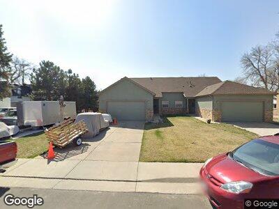
3225 Otis St Wheat Ridge, CO 80033
Barths NeighborhoodEstimated Value: $672,000 - $808,000
2
Beds
2
Baths
1,666
Sq Ft
$451/Sq Ft
Est. Value
About This Home
This home is located at 3225 Otis St, Wheat Ridge, CO 80033 and is currently estimated at $751,067, approximately $450 per square foot. 3225 Otis St is a home located in Jefferson County with nearby schools including Stevens Elementary School, Everitt Middle School, and Wheat Ridge High School.
Ownership History
Date
Name
Owned For
Owner Type
Purchase Details
Closed on
May 4, 2021
Sold by
Monaco Frank L
Bought by
Deangelis Nicole
Current Estimated Value
Purchase Details
Closed on
Mar 18, 2015
Sold by
Pedroza Claudia Ann
Bought by
Monaco Frank L
Purchase Details
Closed on
Sep 12, 2013
Sold by
Monaco Frank Louis
Bought by
Pedroza Claudia Ann
Purchase Details
Closed on
Sep 5, 2003
Sold by
Njbjr Llc
Bought by
Monaco Frank J
Purchase Details
Closed on
Oct 18, 2002
Sold by
Jones John Michael
Bought by
Njbjr Llc
Create a Home Valuation Report for This Property
The Home Valuation Report is an in-depth analysis detailing your home's value as well as a comparison with similar homes in the area
Home Values in the Area
Average Home Value in this Area
Purchase History
| Date | Buyer | Sale Price | Title Company |
|---|---|---|---|
| Monaco Frank L | -- | None Available | |
| Pedroza Claudia Ann | -- | None Available | |
| Monaco Frank J | $275,000 | -- | |
| Njbjr Llc | $110,000 | -- |
Source: Public Records
Mortgage History
| Date | Status | Borrower | Loan Amount |
|---|---|---|---|
| Previous Owner | Njbjr Llc | $396,908 |
Source: Public Records
Tax History Compared to Growth
Tax History
| Year | Tax Paid | Tax Assessment Tax Assessment Total Assessment is a certain percentage of the fair market value that is determined by local assessors to be the total taxable value of land and additions on the property. | Land | Improvement |
|---|---|---|---|---|
| 2024 | $3,970 | $45,402 | $15,401 | $30,001 |
| 2023 | $3,970 | $45,402 | $15,401 | $30,001 |
| 2022 | $3,265 | $36,673 | $15,649 | $21,024 |
| 2021 | $3,310 | $37,728 | $16,099 | $21,629 |
| 2020 | $2,922 | $33,472 | $13,882 | $19,590 |
| 2019 | $2,883 | $33,472 | $13,882 | $19,590 |
| 2018 | $2,662 | $29,877 | $9,344 | $20,533 |
| 2017 | $2,404 | $29,877 | $9,344 | $20,533 |
| 2016 | $2,251 | $26,172 | $6,280 | $19,892 |
| 2015 | $1,701 | $26,172 | $6,280 | $19,892 |
| 2014 | $1,701 | $18,555 | $5,731 | $12,824 |
Source: Public Records
Map
Nearby Homes
- 6755 W 33rd Ave
- 3235 Newland St
- 7085 W 32nd Place
- 3015 Pierce St
- 6246 W 35th Ave
- 6795 W 29th Ave
- 2865 Newland St
- 7340 W 32nd Ave
- 2837 Reed St
- 3230 Vance St
- 6925 W 27th Ave
- 3830 Otis St Unit 1-4
- 6455 W 38th Ave
- 5930 W 34th Ave
- 6162 W 28th Ct
- 3398 Wadsworth Blvd
- 3728 Vance St Unit 1-4
- 7070 W 39th Ave
- 6000 W 29th Ave
- 5801 W 33rd Ave