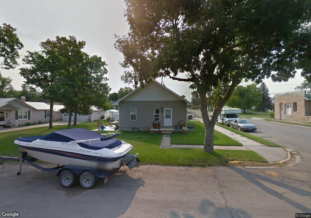
323 W Corcoran St Lewistown, MT 59457
Estimated Value: $200,000 - $291,000
2
Beds
1
Bath
1,032
Sq Ft
$252/Sq Ft
Est. Value
About This Home
This home is located at 323 W Corcoran St, Lewistown, MT 59457 and is currently estimated at $259,940, approximately $251 per square foot. 323 W Corcoran St is a home located in Fergus County with nearby schools including Fergus High School.
Ownership History
Date
Name
Owned For
Owner Type
Purchase Details
Closed on
Aug 22, 2024
Sold by
Lie Tobie J
Bought by
Novotny Alexander L R and Kramer Brianna
Current Estimated Value
Purchase Details
Closed on
Feb 27, 2019
Sold by
Noone Rodney D and Noone Keri L
Bought by
Liedes Tobie J
Home Financials for this Owner
Home Financials are based on the most recent Mortgage that was taken out on this home.
Original Mortgage
$108,800
Interest Rate
4.4%
Mortgage Type
New Conventional
Create a Home Valuation Report for This Property
The Home Valuation Report is an in-depth analysis detailing your home's value as well as a comparison with similar homes in the area
Home Values in the Area
Average Home Value in this Area
Purchase History
| Date | Buyer | Sale Price | Title Company |
|---|---|---|---|
| Novotny Alexander L R | -- | Flying S Title And Escrow | |
| Liedes Tobie J | $136,000 | First American Title |
Source: Public Records
Mortgage History
| Date | Status | Borrower | Loan Amount |
|---|---|---|---|
| Previous Owner | Liedes Tobie J | $108,800 |
Source: Public Records
Tax History Compared to Growth
Tax History
| Year | Tax Paid | Tax Assessment Tax Assessment Total Assessment is a certain percentage of the fair market value that is determined by local assessors to be the total taxable value of land and additions on the property. | Land | Improvement |
|---|---|---|---|---|
| 2025 | $2,100 | $273,800 | $0 | $0 |
| 2024 | $2,100 | $183,500 | $0 | $0 |
| 2023 | $2,107 | $183,500 | $0 | $0 |
| 2022 | $1,925 | $135,200 | $0 | $0 |
| 2021 | $1,562 | $135,200 | $0 | $0 |
| 2020 | $1,771 | $136,200 | $0 | $0 |
| 2019 | $1,759 | $136,200 | $0 | $0 |
| 2018 | $1,106 | $79,000 | $0 | $0 |
| 2017 | $891 | $79,000 | $0 | $0 |
| 2016 | $926 | $65,500 | $0 | $0 |
| 2015 | $728 | $65,500 | $0 | $0 |
| 2014 | $727 | $36,623 | $0 | $0 |
Source: Public Records
Map
Nearby Homes
- 224 W Virginia St
- 320 W Boulevard St
- 229 Deb's Dr
- 412 W Huron St
- 1105 Crowley Ave
- 624 W Broadway St
- 614 Ohio St
- 711 W Huron St
- 115 7th Ave N
- TBD Truck Bypass
- 1016 W Montana St
- 208 2nd St W
- 401 7th Ave S
- 1005 W Washington St
- 1000 Fountain Terrace Dr
- 1011 W Broadway St
- 1102 W Boulevard St
- 701 E Montana St
- 904 Wendell Ave
- 204 E Lake Ave
- 315 W Corcoran St
- 612 4th Ave N
- 320 W Evelyn St
- 314 W Evelyn St
- 324 W Corcoran St
- 411 W Corcoran St
- 402 W Corcoran St
- 312 W Evelyn St
- 404 W Evelyn St
- 316 W Corcoran St
- 618 3rd Ave N
- 408 W Corcoran St
- 614 3rd Ave N
- 410 W Evelyn St
- 304 W Evelyn St
- 308 W Corcoran St
- 413 W Corcoran St
- 412 W Corcoran St
- 509 4th Ave N
- 715 4th Ave N