Estimated Value: $219,000 - $263,000
3
Beds
2
Baths
1,435
Sq Ft
$169/Sq Ft
Est. Value
About This Home
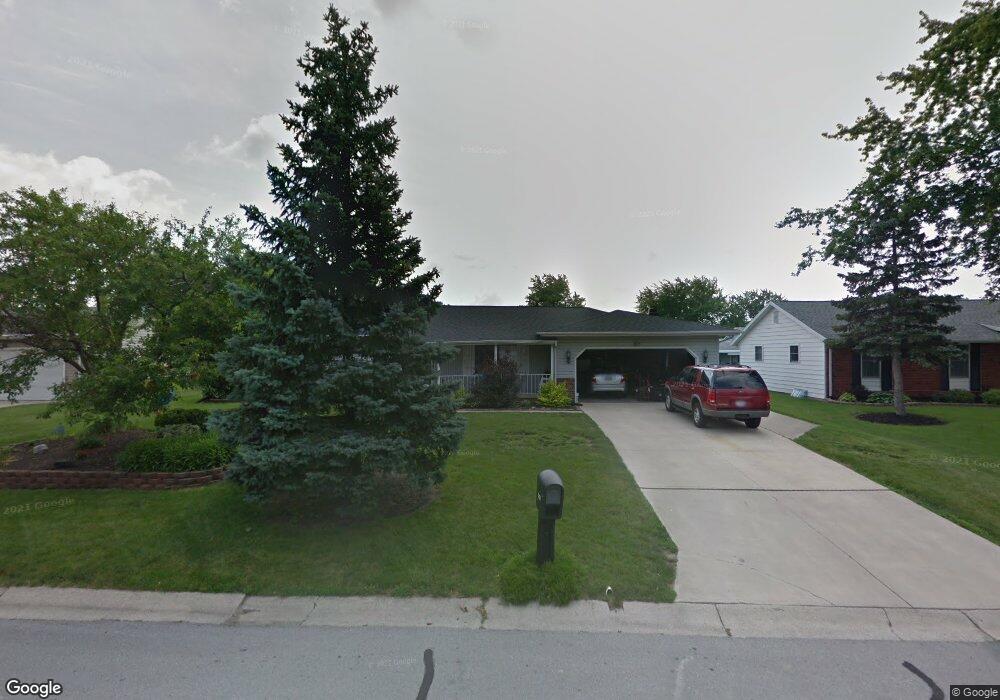
This home is located at 3232 Cynthia Dr, Lima, OH 45801 and is currently estimated at $242,598, approximately $169 per square foot. 3232 Cynthia Dr is a home located in Allen County with nearby schools including Bath Elementary School, Bath Middle School, and Bath High School.
Ownership History
Date
Name
Owned For
Owner Type
Purchase Details
Closed on
Oct 5, 2018
Bought by
Corsaro Staci L
Current Estimated Value
Home Financials for this Owner
Home Financials are based on the most recent Mortgage that was taken out on this home.
Interest Rate
4.71%
Purchase Details
Closed on
Jun 13, 2017
Sold by
Estate Of Ronald Nelson Houston
Bought by
Houston Marilyn K
Purchase Details
Closed on
Apr 1, 1974
Bought by
Houston Ronald N
Create a Home Valuation Report for This Property
The Home Valuation Report is an in-depth analysis detailing your home's value as well as a comparison with similar homes in the area
Home Values in the Area
Average Home Value in this Area
Purchase History
| Date | Buyer | Sale Price | Title Company |
|---|---|---|---|
| Corsaro Staci L | $155,000 | -- | |
| Houston Marilyn K | -- | None Available | |
| Houston Ronald N | $4,300 | -- |
Source: Public Records
Mortgage History
| Date | Status | Borrower | Loan Amount |
|---|---|---|---|
| Closed | Corsaro Staci L | -- |
Source: Public Records
Tax History Compared to Growth
Tax History
| Year | Tax Paid | Tax Assessment Tax Assessment Total Assessment is a certain percentage of the fair market value that is determined by local assessors to be the total taxable value of land and additions on the property. | Land | Improvement |
|---|---|---|---|---|
| 2024 | $3,002 | $67,070 | $11,520 | $55,550 |
| 2023 | $2,785 | $54,080 | $9,280 | $44,800 |
| 2022 | $2,861 | $54,080 | $9,280 | $44,800 |
| 2021 | $2,860 | $54,080 | $9,280 | $44,800 |
| 2020 | $3,157 | $55,690 | $8,860 | $46,830 |
| 2019 | $3,157 | $55,690 | $8,860 | $46,830 |
| 2018 | $2,686 | $55,690 | $8,860 | $46,830 |
| 2017 | $2,589 | $53,450 | $8,860 | $44,590 |
| 2016 | $2,520 | $53,450 | $8,860 | $44,590 |
| 2015 | $2,453 | $53,450 | $8,860 | $44,590 |
| 2014 | $2,453 | $50,270 | $9,210 | $41,060 |
| 2013 | $2,451 | $50,270 | $9,210 | $41,060 |
Source: Public Records
Map
Nearby Homes
- 3252 Stewart Rd
- 1679 E Bluelick Rd
- 108 Highland Lakes Dr
- 0 N Dixie Hwy Unit 308796
- 0 N Dixie Hwy Unit 300253
- 3456 Shearin Ave
- 3270 Bonnieview Dr
- 1503 Findlay Rd Unit Lot 6
- 711 Taylor Ave
- 4080 Brookshore Dr
- 4050 Brookshore Dr
- 307 Ridge Crest Cir
- 105 Watt Ave
- 2370 N McDonel St
- 128 E Lane Ave
- 4619 N Thayer Rd
- 168 Lyre Bird Ln
- 1200 N Main St
- 400 W Northern Ave
- 220 Parklane Dr