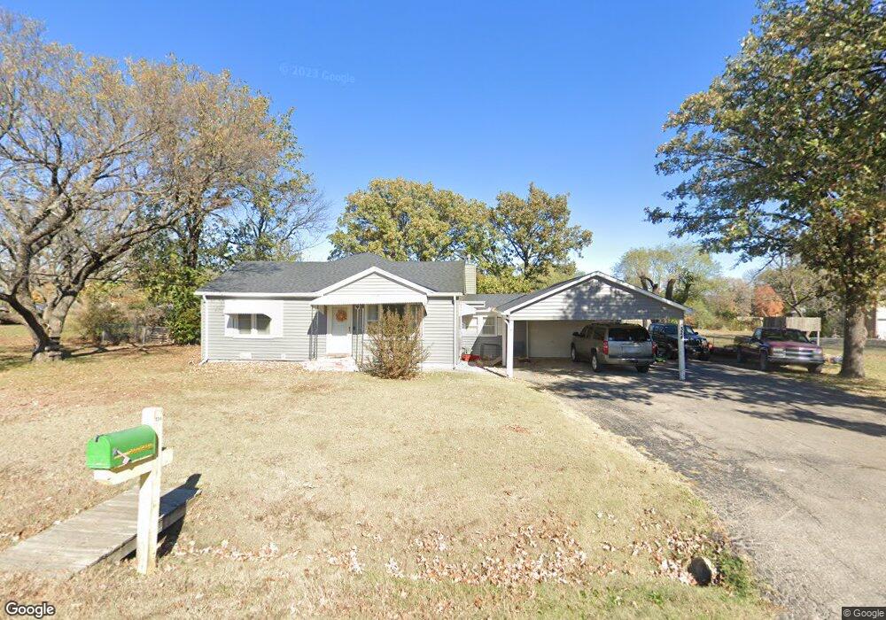
324 W Murdock St Andover, KS 67002
Estimated Value: $221,000 - $236,448
3
Beds
2
Baths
1,922
Sq Ft
$118/Sq Ft
Est. Value
About This Home
This home is located at 324 W Murdock St, Andover, KS 67002 and is currently estimated at $226,612, approximately $117 per square foot. 324 W Murdock St is a home located in Butler County with nearby schools including Cottonwood Elementary School, Andover Middle School, and Andover High School.
Ownership History
Date
Name
Owned For
Owner Type
Purchase Details
Closed on
Jul 19, 2022
Sold by
Nusz Family Trust
Bought by
Cook Kylan D and Cook Mallory G
Current Estimated Value
Home Financials for this Owner
Home Financials are based on the most recent Mortgage that was taken out on this home.
Original Mortgage
$150,000
Outstanding Balance
$119,189
Interest Rate
0.46%
Mortgage Type
New Conventional
Estimated Equity
$107,423
Purchase Details
Closed on
May 22, 2014
Sold by
Nusz Bonnie L
Bought by
Nusz Family Trust
Purchase Details
Closed on
Feb 28, 2011
Sold by
Martin Michelle Devee and Martin Daniel
Bought by
Nusz
Create a Home Valuation Report for This Property
The Home Valuation Report is an in-depth analysis detailing your home's value as well as a comparison with similar homes in the area
Home Values in the Area
Average Home Value in this Area
Purchase History
| Date | Buyer | Sale Price | Title Company |
|---|---|---|---|
| Cook Kylan D | $187,500 | Security First Title | |
| Nusz Family Trust | -- | -- | |
| Nusz Family Trust | -- | -- | |
| Nusz | -- | -- |
Source: Public Records
Mortgage History
| Date | Status | Borrower | Loan Amount |
|---|---|---|---|
| Open | Cook Kylan D | $150,000 |
Source: Public Records
Tax History Compared to Growth
Tax History
| Year | Tax Paid | Tax Assessment Tax Assessment Total Assessment is a certain percentage of the fair market value that is determined by local assessors to be the total taxable value of land and additions on the property. | Land | Improvement |
|---|---|---|---|---|
| 2025 | $30 | $21,023 | $7,060 | $13,963 |
| 2024 | $30 | $20,815 | $3,088 | $17,727 |
| 2023 | $3,272 | $22,034 | $3,088 | $18,946 |
| 2022 | $3,256 | $19,332 | $3,088 | $16,244 |
| 2021 | $2,353 | $15,998 | $3,088 | $12,910 |
| 2020 | $2,426 | $15,104 | $3,088 | $12,016 |
| 2019 | $2,353 | $14,525 | $2,315 | $12,210 |
| 2018 | $2,282 | $14,157 | $2,315 | $11,842 |
| 2017 | $1,953 | $12,155 | $1,918 | $10,237 |
| 2014 | -- | $99,600 | $16,680 | $82,920 |
Source: Public Records
Map
Nearby Homes
- 606 N Lakeside Dr
- 318 Countryside Ct S
- 601 Brentwood Place
- 924 Maplewood Ct
- 602 Brentwood Place
- 620 N Somerset Ct
- 241 Koob Ln
- 328 W 1st St
- 844 N Speyside Cir
- 818 Mccloud Cir
- 818 N Mccloud Cir
- 918 E Lakecrest Dr
- 305 Oakmont Ct
- 826 N Speyside Cir
- 545 N Andover Rd
- 821 N Fairoaks Ct
- 849 N Speyside Cir
- 1009 E Rosemont Ct
- 118 Chapel Dr
- 1013 E Rosemont Ct
- 718 N Broadview Ln
- 308 W Murdock St
- 708 N Broadview Ln
- 311 W Murdock St
- 405 W 8th St
- 723 N Broadview Ln
- 227 W 8th St
- 735 N Broadview Ln
- 204 W Murdock St
- 709 N Broadview Ln
- 753 N Broadview Ln
- 221 W Murdock St
- 306 W 8th St
- 211 W 8th St
- 211 W Murdock St
- 726 Prosperity Ln
- 814 N Broadview Ln
- 700 Prosperity Ln
- 809 N Broadview Ln
- 647 N Broadview Ln