Estimated Value: $418,000 - $461,000
About This Home
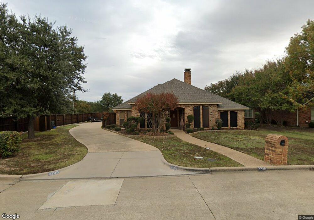
This home is located at 3240 David Dr, Hurst, TX 76054 and is currently estimated at $436,660, approximately $197 per square foot. 3240 David Dr is a home located in Tarrant County with nearby schools including W.A. Porter Elementary School, Smithfield Middle School, and Birdville High School.
Ownership History
We collect this data history from publicly available records. To have your information removed, we recommend requesting removal directly through your county’s website.
Purchase Details
Purchase Details
Home Financials for this Owner
Home Financials are based on the most recent Mortgage that was taken out on this home.Purchase Details
Purchase Details
Home Values in the Area
Average Home Value in this Area
Purchase History
We collect this data history from publicly available records. To have your information removed, we recommend requesting removal directly through your county’s website.
| Date | Buyer | Sale Price | Title Company |
|---|---|---|---|
| -- | None Listed On Document | ||
| -- | Safeco Land Title Co | ||
| $126,660 | -- | ||
| -- | -- |
Mortgage History
We collect this data history from publicly available records. To have your information removed, we recommend requesting removal directly through your county’s website.
| Date | Status | Borrower | Loan Amount |
|---|---|---|---|
| Previous Owner | $118,300 | ||
| Closed | $22,100 |
Tax History
We collect this data history from publicly available records. To have your information removed, we recommend requesting removal directly through your county’s website.
| Year | Tax Paid | Tax Assessment Tax Assessment Total Assessment is a certain percentage of the fair market value that is determined by local assessors to be the total taxable value of land and additions on the property. | Land | Improvement |
|---|---|---|---|---|
| 2025 | $1,829 | $383,000 | $90,000 | $293,000 |
| 2024 | $9,088 | $400,000 | $90,000 | $310,000 |
| 2023 | $8,573 | $392,671 | $90,000 | $302,671 |
| 2022 | $8,432 | $371,177 | $55,000 | $316,177 |
| 2021 | $8,042 | $337,465 | $55,000 | $282,465 |
| 2020 | $7,243 | $307,092 | $55,000 | $252,092 |
| 2019 | $6,734 | $319,596 | $55,000 | $264,596 |
| 2018 | $3,862 | $232,925 | $55,000 | $177,925 |
| 2017 | $5,650 | $255,533 | $55,000 | $200,533 |
| 2016 | $5,137 | $221,017 | $40,000 | $181,017 |
| 2015 | $3,858 | $175,000 | $25,000 | $150,000 |
| 2014 | $3,858 | $175,000 | $25,000 | $150,000 |
Map
- 3229 David Dr
- 3220 Evan Dr
- 713 Ashley Dr
- 3312 S Riley Ct
- 7205 Elm Wood Dr
- 613 Evergreen Dr
- 720 Bridget Way
- 3408 Comanche Trail
- 713 Huey Ct
- 708 Corsair Ct
- 713 Corsair Ct
- 712 Doppler Ct
- 720 Doppler Ct
- 504 Evergreen Dr
- 3517 Stealth Run
- 8966 Hialeah Cir S
- 3513 Stealth Run
- 717 Corsair Ct
- 3408 Osprey Dr
- 3509 Stealth Run
Ask me questions while you tour the home.