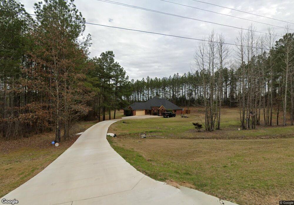
3240 Highway 471 Brandon, MS 39047
Estimated Value: $340,000 - $733,000
4
Beds
5
Baths
2,523
Sq Ft
$194/Sq Ft
Est. Value
About This Home
This home is located at 3240 Highway 471, Brandon, MS 39047 and is currently estimated at $490,121, approximately $194 per square foot. 3240 Highway 471 is a home with nearby schools including Oakdale Elementary School, Northwest Rankin Middle School, and Northwest Rankin High School.
Ownership History
Date
Name
Owned For
Owner Type
Purchase Details
Closed on
Nov 30, 2012
Sold by
Duran Builders Inc
Bought by
Robinson Melvin E and Robinson Lakesher S
Current Estimated Value
Home Financials for this Owner
Home Financials are based on the most recent Mortgage that was taken out on this home.
Original Mortgage
$227,797
Outstanding Balance
$157,826
Interest Rate
3.37%
Mortgage Type
FHA
Estimated Equity
$332,295
Purchase Details
Closed on
Apr 24, 2012
Sold by
Robinson Melvin and Robinson Lakesher
Bought by
Duran Builders Inc A Mississippi Corpo
Create a Home Valuation Report for This Property
The Home Valuation Report is an in-depth analysis detailing your home's value as well as a comparison with similar homes in the area
Home Values in the Area
Average Home Value in this Area
Purchase History
| Date | Buyer | Sale Price | Title Company |
|---|---|---|---|
| Robinson Melvin E | -- | -- | |
| Duran Builders Inc A Mississippi Corpo | -- | -- |
Source: Public Records
Mortgage History
| Date | Status | Borrower | Loan Amount |
|---|---|---|---|
| Open | Robinson Melvin E | $227,797 |
Source: Public Records
Tax History Compared to Growth
Tax History
| Year | Tax Paid | Tax Assessment Tax Assessment Total Assessment is a certain percentage of the fair market value that is determined by local assessors to be the total taxable value of land and additions on the property. | Land | Improvement |
|---|---|---|---|---|
| 2024 | $1,701 | $18,577 | $0 | $0 |
| 2023 | $1,588 | $17,529 | $0 | $0 |
| 2022 | $1,562 | $17,529 | $0 | $0 |
| 2021 | $1,543 | $17,351 | $0 | $0 |
| 2020 | $1,543 | $17,351 | $0 | $0 |
| 2019 | $1,378 | $15,401 | $0 | $0 |
| 2018 | $1,347 | $15,401 | $0 | $0 |
| 2017 | $1,347 | $15,401 | $0 | $0 |
| 2016 | $1,106 | $15,122 | $0 | $0 |
| 2015 | $1,106 | $15,122 | $0 | $0 |
| 2014 | $1,074 | $15,122 | $0 | $0 |
| 2013 | $1,074 | $15,122 | $0 | $0 |
Source: Public Records
Map
Nearby Homes
- 0 Stull Rd Unit 24042681
- 0 Stull Rd Unit 10 11529116
- 1 Highway 25 Hwy
- Lot 10 Mt Helms
- 000 Highway 25 Hwy
- 416 Lennon Ln
- 208 Kitty Hawk Cir
- 0 Fallen Oak Dr
- 211 Lost Oak Ln
- 212 Lost Oak Ln
- 130 Horseshoe Cir
- 904 Northwood Cir
- 290 Mount Helm Rd
- Lot 11 Mount Helm Rd
- Lot 7 Mount Helm Rd
- Lot 5 Mount Helm Rd
- 0 Hamilton Place Unit 4122193
- 1053 Woodbridge Dr
- 0 Freedom Farms Crossing Unit 4127065
- 1005 Freedom Farms Crossing
- 3250 Mississippi 471
- 3237 Highway 471
- 3293 Highway 471
- 406 Duke Ct
- 212 Duchess Ct
- 324 Royal Pond Cir
- 200 Duchess Ct
- 202 Duchess Ct
- 211 Duchess Ct
- 213 Duchess Ct
- 159 Stull Rd
- 167 Stull Rd
- 124 Stull Rd
- 3305 Highway 471
- 103 John Hill Rd
- 160 Stull Rd
- 148 Stull Rd
- 127 John Hill Rd
- 2897 Highway 471
- 2897 Hwy 471 None