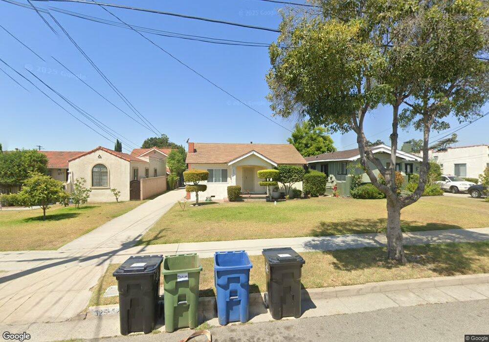
325 S 7th St Alhambra, CA 91801
Alhambra Vista NeighborhoodEstimated Value: $1,193,000 - $1,243,000
4
Beds
3
Baths
1,936
Sq Ft
$629/Sq Ft
Est. Value
About This Home
This home is located at 325 S 7th St, Alhambra, CA 91801 and is currently estimated at $1,217,066, approximately $628 per square foot. 325 S 7th St is a home located in Los Angeles County with nearby schools including William Northrup Elementary School, Alhambra High School, and All Souls World Language Catholic School.
Ownership History
Date
Name
Owned For
Owner Type
Purchase Details
Closed on
Nov 9, 1999
Sold by
Pimentel Romeo C and Pimentel Felicitas A
Bought by
Pimentel Romeo C and Pimentel Felicitas A
Current Estimated Value
Home Financials for this Owner
Home Financials are based on the most recent Mortgage that was taken out on this home.
Original Mortgage
$99,995
Interest Rate
7.68%
Mortgage Type
Stand Alone Second
Purchase Details
Closed on
Aug 5, 1999
Sold by
Pimentel Romeo C and Pimentel Felicitas A
Bought by
Pimentel Romeo C and Pimentel Felicitas A
Create a Home Valuation Report for This Property
The Home Valuation Report is an in-depth analysis detailing your home's value as well as a comparison with similar homes in the area
Home Values in the Area
Average Home Value in this Area
Purchase History
| Date | Buyer | Sale Price | Title Company |
|---|---|---|---|
| Pimentel Romeo C | -- | Gateway Title Company | |
| Pimentel Romeo | -- | Gateway Title Company | |
| Pimentel Romeo C | -- | -- |
Source: Public Records
Mortgage History
| Date | Status | Borrower | Loan Amount |
|---|---|---|---|
| Closed | Pimentel Romeo | $99,995 |
Source: Public Records
Tax History
| Year | Tax Paid | Tax Assessment Tax Assessment Total Assessment is a certain percentage of the fair market value that is determined by local assessors to be the total taxable value of land and additions on the property. | Land | Improvement |
|---|---|---|---|---|
| 2025 | $2,101 | $131,774 | $67,368 | $64,406 |
| 2024 | $2,101 | $129,192 | $66,048 | $63,144 |
| 2023 | $2,156 | $126,659 | $64,753 | $61,906 |
| 2022 | $2,079 | $124,177 | $63,484 | $60,693 |
| 2021 | $2,049 | $121,743 | $62,240 | $59,503 |
| 2020 | $2,039 | $120,495 | $61,602 | $58,893 |
| 2019 | $1,992 | $118,134 | $60,395 | $57,739 |
| 2018 | $1,899 | $115,818 | $59,211 | $56,607 |
| 2016 | $1,755 | $111,322 | $56,912 | $54,410 |
| 2015 | $1,732 | $109,651 | $56,058 | $53,593 |
| 2014 | $1,727 | $107,504 | $54,960 | $52,544 |
Source: Public Records
Map
Nearby Homes
- 213 S Atlantic Blvd
- 228 S Olive Ave Unit A302
- 204 S Olive Ave
- 408 1B W Main
- 101 S Olive Ave
- 580 W Main St Unit 318
- 102 S Curtis Ave
- 410 W Main St Unit 231
- 408 W Main St Unit 2G
- 28 N 3rd St
- 1515 W Commonwealth Ave
- 200 N 5th St Unit 311
- 200 N 5th St Unit 101
- 200 N 5th St Unit 108
- 904 S 2nd St Unit E
- 25 Palmetto Dr Unit A
- 611 S Marguerita Ave
- 1010 S Atlantic Blvd
- 111 N 2nd St Unit 316
- 78 E Bay State St
Your Personal Tour Guide
Ask me questions while you tour the home.