


3257 Trail Creek Rd Idaho Springs, CO 80452
Estimated payment $824/month
Highlights
- Heavily Wooded Lot
- Secluded Lot
- Home fronts a stream
- Mountainous Lot
- No HOA
- Natural State Vegetation
About This Lot
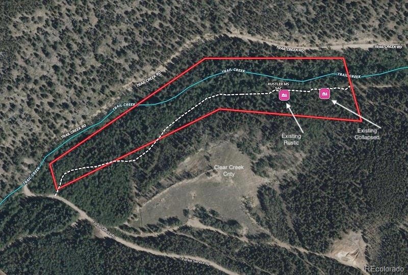
This 5 Acre parcel is a one of 7 Trail Creek Area Mining Claims offered just outside the Rocky Mountain Gateway town of Idaho Springs, Colorado. The larger collection of all 7 individual claims totals 32.042 acres with one additional 5.16 ac offering (MLS# 6621345) and the remaining 5 contiguous claims (MLS# 9105870) offered together at 21.882 acres.
The 5 acre “Rustler MS” parcel lies at the end of Trail Creek Road from about .3 mile to .6 mile from the end of the county maintained portion. The Creek traverses the entire length of the property with cascading falls and pools within the densely forested landscape and a 2 track path also runs the length with access from the upper west end where Trail Creek Rd transitions to a Forest Service Rd. An abandoned rustic cabin exists upon the property and could perhaps be renovated to habitability. The collapsed remains of another old cabin provide a window in to the rich past of the area. The neighboring parcel to the south is owned by Clear Creek County providing an added layer of privacy from other landowners. For 3 generations the ownership family has enjoyed these lands as a place to retreat, camp and recreate; from the lovely trickling stream of Trail Creek upon the “Rustler MS” parcel to the expansive rocky mountain views offered from the middle clustered parcels and the high vantage point of the “Maximum” parcel.
Listing Agent
Keller Williams Foothills Realty, LLC Brokerage Email: info@coloradolrl.com License #100035328 Listed on: 06/21/2025

Property Details
Property Type
- Land
Est. Annual Taxes
- $251
Lot Details
- 5 Acre Lot
- Home fronts a stream
- Dirt Road
- Natural State Vegetation
- Secluded Lot
- Mountainous Lot
- Heavily Wooded Lot
- Many Trees
- Property is zoned M-1
Community Details
- No Home Owners Association
Listing and Financial Details
- Assessor Parcel Number 1835-313-00-007
Map
Home Values in the Area
Average Home Value in this Area
Tax History
| Year | Tax Paid | Tax Assessment Tax Assessment Total Assessment is a certain percentage of the fair market value that is determined by local assessors to be the total taxable value of land and additions on the property. | Land | Improvement |
|---|---|---|---|---|
| 2024 | $251 | $3,440 | $1,360 | $2,080 |
| 2023 | $250 | $3,440 | $1,360 | $2,080 |
| 2022 | $403 | $5,500 | $2,450 | $3,050 |
| 2021 | $405 | $5,660 | $2,520 | $3,140 |
| 2020 | $348 | $5,180 | $1,680 | $3,500 |
| 2019 | $347 | $5,180 | $1,680 | $3,500 |
| 2018 | $248 | $3,810 | $1,040 | $2,770 |
| 2017 | $259 | $3,810 | $1,040 | $2,770 |
| 2016 | $223 | $3,340 | $1,250 | $2,090 |
| 2015 | -- | $3,340 | $1,250 | $2,090 |
| 2014 | -- | $3,180 | $1,110 | $2,070 |
Property History
| Date | Event | Price | Change | Sq Ft Price |
|---|---|---|---|---|
| 07/09/2025 07/09/25 | Pending | -- | -- | -- |
| 06/21/2025 06/21/25 | Price Changed | $414,178 | +185.6% | -- |
| 06/21/2025 06/21/25 | For Sale | $145,000 | -57.6% | -- |
| 06/20/2025 06/20/25 | For Sale | $342,178 | -- | -- |
Source: REcolorado®
MLS Number: 8233880
APN: 1835-313-00-007
Disclaimer: Certain information contained herein is derived from information provided by parties other than Homes.com. All information provided is deemed reliable, but is not guaranteed to be accurate and should be independently verified.
![]() The content relating to real estate for sale in this Web site comes in part from the Internet Data eXchange (“IDX”) program of METROLIST, INC., DBA RECOLORADO®. Real estate listings held by brokers other than Ten-X are marked with the IDX Logo. This information is being provided for the consumers’ personal, non-commercial use and may not be used for any other purpose. All information subject to change and should be independently verified.
The content relating to real estate for sale in this Web site comes in part from the Internet Data eXchange (“IDX”) program of METROLIST, INC., DBA RECOLORADO®. Real estate listings held by brokers other than Ten-X are marked with the IDX Logo. This information is being provided for the consumers’ personal, non-commercial use and may not be used for any other purpose. All information subject to change and should be independently verified.
This publication is designed to provide information with regard to the subject matter covered. It is displayed with the understanding that the publisher and authors are not engaged in rendering real estate, legal, accounting, tax, or other professional services and that the publisher and authors are not offering such advice in this publication. If real estate, legal, or other expert assistance is required, the services of a competent, professional person should be sought.
The information contained in this publication is subject to change without notice. METROLIST, INC., DBA RECOLORADO MAKES NO WARRANTY OF ANY KIND WITH REGARD TO THIS MATERIAL, INCLUDING, BUT NOT LIMITED TO, THE IMPLIED WARRANTIES OF MERCHANTABILITY AND FITNESS FOR A PARTICULAR PURPOSE. METROLIST, INC., DBA RECOLORADO SHALL NOT BE LIABLE FOR ERRORS CONTAINED HEREIN OR FOR ANY DAMAGES IN CONNECTION WITH THE FURNISHING, PERFORMANCE, OR USE OF THIS MATERIAL.
PUBLISHER’S NOTICE: All real estate advertised herein is subject to the Federal Fair Housing Act and the Colorado Fair Housing Act, which Acts make it illegal to make or publish any advertisement that indicates any preference, limitation, or discrimination based on race, color, religion, sex, handicap, familial status, or national origin.
METROLIST, INC., DBA RECOLORADO will not knowingly accept any advertising for real estate that is in violation of the law. All persons are hereby informed that all dwellings advertised are available on an equal opportunity basis.
© 2025 METROLIST, INC., DBA RECOLORADO® – All Rights Reserved. 6455 S. Yosemite St., Suite 500 Greenwood Village, CO 80111 USA
ALL RIGHTS RESERVED WORLDWIDE. No part of this publication may be reproduced, adapted, translated, stored in a retrieval system or transmitted in any form or by any means, electronic, mechanical, photocopying, recording, or otherwise, without the prior written permission of the publisher. The information contained herein including but not limited to all text, photographs, digital images, virtual tours, may be seeded and monitored for protection and tracking.
- 000 Forest Service
- 0 Lamartine Rd Unit REC1819231
- TBD Miners Candle Rd
- Group 13 Lamartine Rd Unit 15146
- 000 Lamartine Rd
- Group 14 Lamartine Rd Unit 15890, 14944
- Group 12 Lamartine Rd Unit 6510, 12665, 12666,
- Group 11 Lamartine Rd Unit 4957,15855,6376
- Group 10 Lamartine Rd Unit 6398
- Group 9 Lamartine Rd Unit 7723/15146
- Group 7 Lamartine Rd Unit 14283,6510
- Group 6 Lamartine Rd Unit 6510, 12667
- Group 5 Lamartine Rd
- Group 2-3 Lamartine Rd Unit 6295
- Group 2-2 Lamartine Rd Unit 2379A
- Group 2-1 Lamartine Rd Unit 5731
- Group 1 Lamartine Rd
- 000 W Range
- 0 Hecla and Olympic Mines Unit REC5313521
- 00 Lamartine Rd