


3267 Old West Point Rd Columbus, MS 39701
Estimated payment $2,564/month
Highlights
- Traditional Architecture
- Breakfast Area or Nook
- Front Porch
- No HOA
- Fireplace
- 2 Car Attached Garage
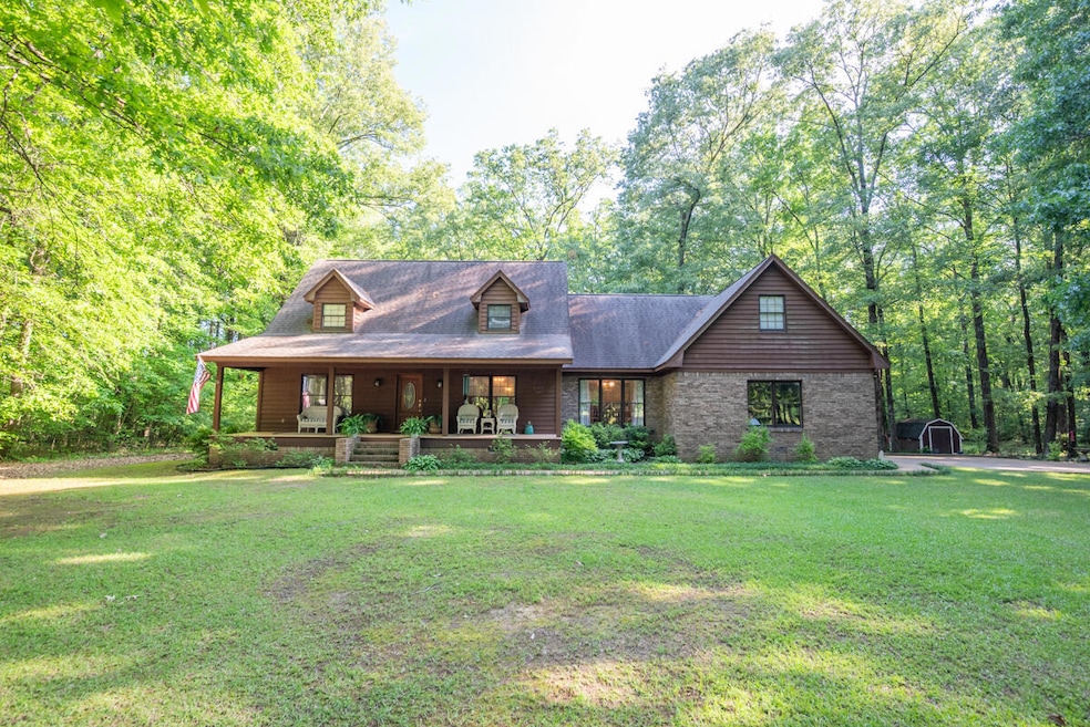
About This Home
Meticulously maintained custom-built 3-bedroom, 2.5 bathroom home offers the perfect balance of privacy and convenience. Nestled on 10.6 serene, wooded acres, the property features a spacious bonus room that can easily serve as a 4th bedroom, home office, or media space. Inside, the well-appointed kitchen, breakfast room, and sunroom—ideal spots to enjoy your morning coffee while watching birds, deer, and squirrels right outside your window. Cozy up in the inviting living room beside the gas fireplace, or unwind on the charming front porch where time seems to stand still.
Designed for both everyday living and special occasions, the home also includes a formal dining room and a cheerful breakfast area. just minutes from the amenities of Columbus, West Point, and Starkville.
Home Details
Home Type
- Single Family
Est. Annual Taxes
- $796
Year Built
- Built in 1996
Lot Details
- 10.6 Acre Lot
Parking
- 2 Car Attached Garage
Home Design
- Traditional Architecture
- Brick Exterior Construction
- Slab Foundation
- Architectural Shingle Roof
Interior Spaces
- 3,341 Sq Ft Home
- Fireplace
Kitchen
- Breakfast Area or Nook
- Stove
- Microwave
- Dishwasher
- Disposal
Flooring
- Carpet
- Tile
Bedrooms and Bathrooms
- 4 Bedrooms
Outdoor Features
- Patio
- Front Porch
Utilities
- Central Heating and Cooling System
- Septic Tank
Community Details
- No Home Owners Association
Listing and Financial Details
- Assessor Parcel Number 08E000002302
Map
Home Values in the Area
Average Home Value in this Area
Tax History
| Year | Tax Paid | Tax Assessment Tax Assessment Total Assessment is a certain percentage of the fair market value that is determined by local assessors to be the total taxable value of land and additions on the property. | Land | Improvement |
|---|---|---|---|---|
| 2025 | $796 | $17,609 | $0 | $0 |
| 2024 | $796 | $17,609 | $0 | $0 |
| 2023 | $792 | $15,843 | $0 | $0 |
| 2022 | $793 | $15,843 | $0 | $0 |
| 2021 | $763 | $15,843 | $0 | $0 |
| 2020 | $1,068 | $15,843 | $0 | $0 |
| 2019 | $1,089 | $15,714 | $0 | $0 |
| 2018 | $1,089 | $15,596 | $0 | $0 |
| 2017 | $1,027 | $15,596 | $0 | $0 |
| 2016 | $1,027 | $15,596 | $0 | $0 |
| 2015 | $1,060 | $15,985 | $0 | $0 |
| 2014 | $1,060 | $15,985 | $0 | $0 |
Property History
| Date | Event | Price | List to Sale | Price per Sq Ft |
|---|---|---|---|---|
| 11/03/2025 11/03/25 | Price Changed | $475,000 | -1.9% | $142 / Sq Ft |
| 10/11/2025 10/11/25 | Price Changed | $484,000 | -3.2% | $145 / Sq Ft |
| 09/15/2025 09/15/25 | For Sale | $499,900 | 0.0% | $150 / Sq Ft |
| 08/10/2025 08/10/25 | Off Market | -- | -- | -- |
| 04/30/2025 04/30/25 | For Sale | $499,900 | -- | $150 / Sq Ft |
Purchase History
| Date | Type | Sale Price | Title Company |
|---|---|---|---|
| Warranty Deed | -- | None Listed On Document | |
| Quit Claim Deed | -- | None Available | |
| Quit Claim Deed | -- | None Available | |
| Warranty Deed | -- | None Available |
Mortgage History
| Date | Status | Loan Amount | Loan Type |
|---|---|---|---|
| Previous Owner | $113,100 | New Conventional |
Source: Golden Triangle Association of REALTORS®
MLS Number: 25-857
APN: 08E00-00-02302
- 0 Hwy 45 N Unit 25-1761
- 2 S Frontage Rd
- 4 S Frontage Rd
- 0 S Frontage Road Lot #1 Unit 25-579
- 0 S Frontage Road Lot #3 Unit 25-581
- 0 S Frontage Road Lot #5 Unit 25-583
- 1381 S Frontage Rd
- 1291 S Frontage Rd
- 49 Billy Casper Dr
- 100 Breezeway Cove
- 112 Breezeway Cove
- 96 Breezeway Cove
- 110 Breezeway Cove
- 28 Breezeway Cove
- 23 Breezeway Cove
- North side Wilkins-Wise Rd
- 0 Officers Lake Rd
- 0 Golden Horn Rd
- 98 Crepe Myrtle Dr
- 112 Gardenia Dr
- 96 Breezeway Cove
- 300 Holly Hills Rd
- 2301 5th St N
- 307 Hospital Dr
- 1127 6th St N
- 102 Newbell Rd
- 632 31st Ave N
- 622 4th St S Unit A
- 412 6th St S Unit 6
- 905 8th Ave N
- 320 N 8th St
- 803 10th St N
- 605 Leigh Dr
- 310 12th St N
- 419 10th St S
- 222 Carr Rd
- 1609 Chickasaw Dr
- 1101-1105 11th Ave S
- 1812 Seminole Rd
- 1301 20th St N
