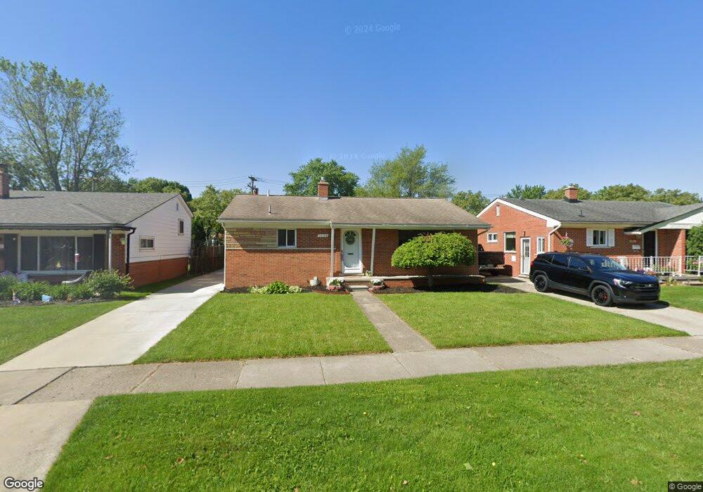
32743 Mackenzie Dr Westland, MI 48185
Estimated Value: $235,646 - $274,000
--
Bed
1
Bath
1,178
Sq Ft
$218/Sq Ft
Est. Value
About This Home
This home is located at 32743 Mackenzie Dr, Westland, MI 48185 and is currently estimated at $256,912, approximately $218 per square foot. 32743 Mackenzie Dr is a home located in Wayne County with nearby schools including Hayes Elementary School, Cooper Upper Elementary School, and Emerson Middle School.
Ownership History
Date
Name
Owned For
Owner Type
Purchase Details
Closed on
Sep 15, 2021
Sold by
Austria Gavin and Austria Sarah
Bought by
Austria Gavin and Austria Sarah
Current Estimated Value
Home Financials for this Owner
Home Financials are based on the most recent Mortgage that was taken out on this home.
Original Mortgage
$160,000
Outstanding Balance
$145,371
Interest Rate
2.7%
Mortgage Type
New Conventional
Estimated Equity
$111,541
Purchase Details
Closed on
Aug 12, 2019
Sold by
Ahmad Mohamad and Nhm Group 1 Inc
Bought by
Austria Gavin and Carney Sarah
Purchase Details
Closed on
Jul 20, 2018
Sold by
Angeline Seman Revocable Trust
Bought by
Nhm Group Llc
Purchase Details
Closed on
Jul 25, 2012
Sold by
Seman Angeline and Seman John F
Bought by
Angeline Seman Revocable Trust
Create a Home Valuation Report for This Property
The Home Valuation Report is an in-depth analysis detailing your home's value as well as a comparison with similar homes in the area
Home Values in the Area
Average Home Value in this Area
Purchase History
| Date | Buyer | Sale Price | Title Company |
|---|---|---|---|
| Austria Gavin | -- | Fidelity National Ttl Group | |
| Austria Gavin | $164,000 | Fidelity National Title | |
| Nhm Group Llc | $80,000 | Minnesota Title Agency | |
| Angeline Seman Revocable Trust | -- | None Available |
Source: Public Records
Mortgage History
| Date | Status | Borrower | Loan Amount |
|---|---|---|---|
| Open | Austria Gavin | $160,000 |
Source: Public Records
Tax History Compared to Growth
Tax History
| Year | Tax Paid | Tax Assessment Tax Assessment Total Assessment is a certain percentage of the fair market value that is determined by local assessors to be the total taxable value of land and additions on the property. | Land | Improvement |
|---|---|---|---|---|
| 2025 | $3,460 | $111,600 | $0 | $0 |
| 2024 | $3,460 | $103,400 | $0 | $0 |
| 2023 | $3,304 | $93,700 | $0 | $0 |
| 2022 | $3,798 | $81,100 | $0 | $0 |
| 2021 | $3,704 | $77,400 | $0 | $0 |
| 2020 | $3,664 | $73,200 | $0 | $0 |
| 2019 | $4,286 | $70,800 | $0 | $0 |
| 2018 | $1,676 | $59,400 | $0 | $0 |
| 2017 | $773 | $55,300 | $0 | $0 |
| 2016 | $2,034 | $55,700 | $0 | $0 |
| 2015 | $3,745 | $47,700 | $0 | $0 |
| 2013 | $3,628 | $37,070 | $0 | $0 |
| 2012 | $1,671 | $37,130 | $0 | $0 |
Source: Public Records
Map
Nearby Homes
- 33211 Anita Dr
- 32725 Joy Rd
- 32451 Sandra Ln
- 32724 Hees St
- 32047 Anita Dr
- 32327 Washington St
- 9243 Montana St
- 8824 Nevada St
- 33312 Lynx St
- 8332 Berwick Dr
- 7946 Moonwood Place
- 33030 Cowan Rd
- 32611 Vermont St
- 7872 Ritz Ave
- 7436 Cochise St
- 9212 Idaho St
- 8219 Roselawn St
- 31640 Ann Arbor Trail
- 9253 Idaho St
- 33632 Cindy St
- 32753 Mackenzie Dr
- 32733 Mackenzie Dr
- 32763 Mackenzie Dr
- 32740 Merritt Dr
- 32750 Merritt Dr
- 32730 Merritt Dr
- 8343 Rae Dr
- 32811 Mackenzie Dr
- 8329 Rae Dr Unit Bldg-Unit
- 8329 Rae Dr
- 32746 Mackenzie Dr
- 32736 Mackenzie Dr
- 32756 Mackenzie Dr
- 8315 Rae Dr
- 32800 Merritt Dr
- 8417 Rae Dr
- 32821 Mackenzie Dr
- 32808 Merritt Dr
- 32814 Mackenzie Dr
- 32831 Mackenzie Dr