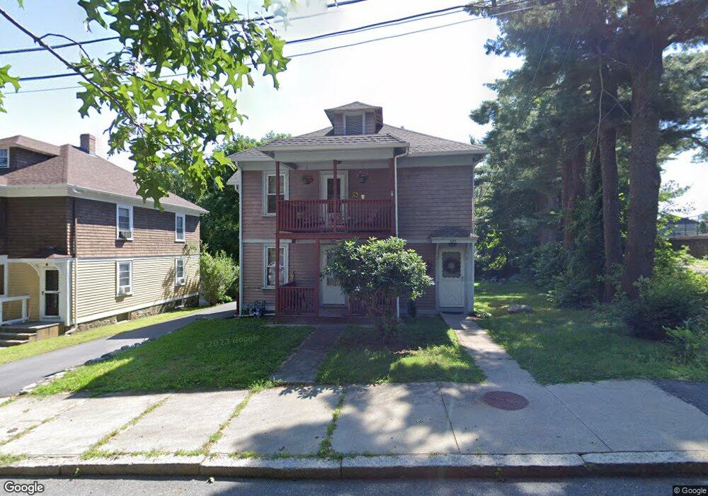
329 Bennett St Woonsocket, RI 02895
Bernon District NeighborhoodEstimated Value: $389,000 - $422,000
4
Beds
2
Baths
1,974
Sq Ft
$209/Sq Ft
Est. Value
About This Home
This home is located at 329 Bennett St, Woonsocket, RI 02895 and is currently estimated at $411,668, approximately $208 per square foot. 329 Bennett St is a home located in Providence County with nearby schools including Woonsocket High School, Founders Academy, and Beacon Charter School.
Ownership History
Date
Name
Owned For
Owner Type
Purchase Details
Closed on
Mar 15, 2011
Sold by
Deslauriers Keith E and Deslauriers Amy D
Bought by
Hawkins Lynn A and Hawkins Darrell J
Current Estimated Value
Purchase Details
Closed on
Jun 24, 2005
Sold by
Desjarlais Paul J
Bought by
Deslauriers Keith E and Deslauriers Amy D
Home Financials for this Owner
Home Financials are based on the most recent Mortgage that was taken out on this home.
Original Mortgage
$269,676
Interest Rate
5.82%
Mortgage Type
VA
Create a Home Valuation Report for This Property
The Home Valuation Report is an in-depth analysis detailing your home's value as well as a comparison with similar homes in the area
Home Values in the Area
Average Home Value in this Area
Purchase History
| Date | Buyer | Sale Price | Title Company |
|---|---|---|---|
| Hawkins Lynn A | $106,000 | -- | |
| Hawkins Lynn A | $106,000 | -- | |
| Deslauriers Keith E | $264,000 | -- | |
| Deslauriers Keith E | $264,000 | -- |
Source: Public Records
Mortgage History
| Date | Status | Borrower | Loan Amount |
|---|---|---|---|
| Previous Owner | Deslauriers Keith E | $269,676 | |
| Previous Owner | Deslauriers Keith E | $57,000 |
Source: Public Records
Tax History
| Year | Tax Paid | Tax Assessment Tax Assessment Total Assessment is a certain percentage of the fair market value that is determined by local assessors to be the total taxable value of land and additions on the property. | Land | Improvement |
|---|---|---|---|---|
| 2025 | $4,502 | $400,900 | $90,700 | $310,200 |
| 2024 | $4,090 | $281,300 | $92,400 | $188,900 |
| 2023 | $3,933 | $281,300 | $92,400 | $188,900 |
| 2022 | $3,933 | $281,300 | $92,400 | $188,900 |
| 2021 | $2,995 | $126,100 | $37,700 | $88,400 |
| 2020 | $3,026 | $126,100 | $37,700 | $88,400 |
| 2018 | $3,036 | $126,100 | $37,700 | $88,400 |
| 2017 | $3,552 | $118,000 | $41,200 | $76,800 |
| 2016 | $3,757 | $118,000 | $41,200 | $76,800 |
| 2015 | $4,316 | $118,000 | $41,200 | $76,800 |
| 2014 | $4,183 | $116,400 | $45,400 | $71,000 |
Source: Public Records
Map
Nearby Homes
- 74 Maple St
- 345 Carrington Ave
- 346 Carrington Ave
- 24 Paradis Ave
- 410 Carrington Ave
- 526 Bernon St
- 59 Division St
- 233 Grove St
- 190 Crawford St
- 219 Crawford St
- 70 W Park Place
- 35 Greene St
- 18 Villa Nova St
- 0 Irving Lot 206 Ave Unit 1397321
- 414 Rhode Island Ave
- 15 Knight St
- 0 Irving Lot 192 Ave Unit 1383138
- 379 Front St
- 99 Allen St Unit 205
- 180 Allen St Unit 104
- 325 Bennett St
- 305 Bennett St
- 225 Roberts St
- 245 Roberts St
- 215 Roberts St
- 777 Bernon St
- 787 Bernon St
- 765 Bernon St
- 749 Bernon St
- 735 Bernon St
- 733 Bernon St
- 320 Bennett St Unit 59
- 320 Bennett St Unit 58
- 320 Bennett St Unit 57
- 320 Bennett St Unit 56
- 320 Bennett St Unit 55
- 320 Bennett St Unit 54
- 320 Bennett St Unit 53
- 320 Bennett St Unit 52
- 320 Bennett St Unit 51
Your Personal Tour Guide
Ask me questions while you tour the home.