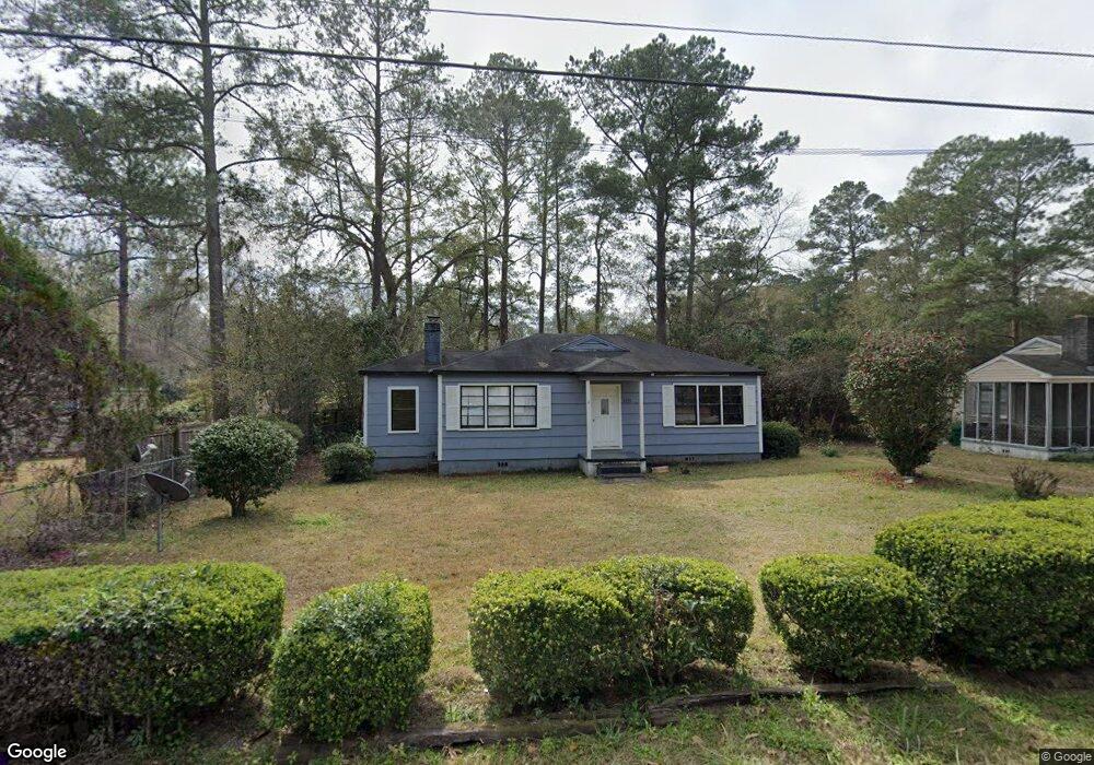
329 Canna Dr Valdosta, GA 31602
Estimated Value: $124,000 - $161,000
--
Bed
2
Baths
1,184
Sq Ft
$121/Sq Ft
Est. Value
About This Home
This home is located at 329 Canna Dr, Valdosta, GA 31602 and is currently estimated at $142,773, approximately $120 per square foot. 329 Canna Dr is a home located in Lowndes County with nearby schools including S.L. Mason Elementary School, Valdosta Middle School, and Valdosta High School.
Ownership History
Date
Name
Owned For
Owner Type
Purchase Details
Closed on
Nov 24, 2014
Sold by
Don Brotherton Properties
Bought by
Lohning Anthony
Current Estimated Value
Home Financials for this Owner
Home Financials are based on the most recent Mortgage that was taken out on this home.
Original Mortgage
$51,000
Interest Rate
3.95%
Mortgage Type
New Conventional
Purchase Details
Closed on
Jan 16, 2014
Sold by
Davis Jamie M
Bought by
Don Brotherton Properties Llc
Purchase Details
Closed on
Jul 18, 1995
Sold by
Davis Raymond J
Bought by
Davis Raymond J and Davis Janie
Purchase Details
Closed on
May 9, 1980
Bought by
Davis Raymond J and Davis Evo
Purchase Details
Closed on
Aug 19, 1976
Bought by
Ross George S
Purchase Details
Closed on
May 26, 1975
Bought by
Ward Raleigh B and Ward Joan M
Purchase Details
Closed on
Oct 15, 1971
Bought by
Johnson Wm F
Create a Home Valuation Report for This Property
The Home Valuation Report is an in-depth analysis detailing your home's value as well as a comparison with similar homes in the area
Home Values in the Area
Average Home Value in this Area
Purchase History
| Date | Buyer | Sale Price | Title Company |
|---|---|---|---|
| Lohning Anthony | $60,000 | -- | |
| Don Brotherton Properties Llc | $35,000 | -- | |
| Davis Raymond J | -- | -- | |
| Davis Raymond J | $29,400 | -- | |
| Ross George S | $7,500 | -- | |
| Ward Raleigh B | $3,000 | -- | |
| Johnson Wm F | $14,700 | -- |
Source: Public Records
Mortgage History
| Date | Status | Borrower | Loan Amount |
|---|---|---|---|
| Closed | Lohning Anthony | $51,000 |
Source: Public Records
Tax History Compared to Growth
Tax History
| Year | Tax Paid | Tax Assessment Tax Assessment Total Assessment is a certain percentage of the fair market value that is determined by local assessors to be the total taxable value of land and additions on the property. | Land | Improvement |
|---|---|---|---|---|
| 2024 | $1,072 | $38,369 | $4,500 | $33,869 |
| 2023 | $1,072 | $41,695 | $4,500 | $37,195 |
| 2022 | $903 | $26,716 | $4,500 | $22,216 |
| 2021 | $929 | $26,716 | $4,500 | $22,216 |
| 2020 | $949 | $26,716 | $4,500 | $22,216 |
| 2019 | $948 | $26,716 | $4,500 | $22,216 |
| 2018 | $961 | $26,716 | $4,500 | $22,216 |
| 2017 | $967 | $26,716 | $4,500 | $22,216 |
| 2016 | $966 | $26,716 | $4,500 | $22,216 |
| 2015 | $796 | $33,551 | $4,500 | $29,051 |
| 2014 | -- | $33,551 | $4,500 | $29,051 |
Source: Public Records
Map
Nearby Homes
- 333 Canna Dr
- 314 Oak Center Place
- 315 Canna Dr
- 409 Georgetown Cir
- 410 Georgetown Cir
- 2503 N Oak St
- 2908 Fawnwood Cir
- 312 Eager Rd
- 2826 Bud McKey Cir
- 805 Millpond Rd
- 2208 N Oak St
- 2204 N Toombs St
- 309 W Park Ave
- 2905 Northfield Rd
- 3012 Wendover Rd
- 209 W Park Ave
- 213 E Northside Dr
- 2112 Azalea Dr
- 1 Fox Hollow Cir
- 604 Azalea Cir