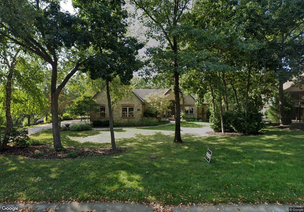
329 NW Rockhill Ln Lees Summit, MO 64081
Estimated Value: $668,193 - $724,000
3
Beds
4
Baths
2,372
Sq Ft
$292/Sq Ft
Est. Value
About This Home
This home is located at 329 NW Rockhill Ln, Lees Summit, MO 64081 and is currently estimated at $693,731, approximately $292 per square foot. 329 NW Rockhill Ln is a home located in Jackson County with nearby schools including Cedar Creek Elementary School, Pleasant Lea Middle School, and Lee's Summit Senior High School.
Ownership History
Date
Name
Owned For
Owner Type
Purchase Details
Closed on
Sep 5, 2007
Sold by
Pfeifer King Building Corp
Bought by
Russo Frank J and Sullivan Russo Colleen
Current Estimated Value
Purchase Details
Closed on
Dec 19, 2003
Sold by
Russo Frank J and Sullivan Russo Colleen
Bought by
Russo Frank J and Sullivan Russo Colleen
Create a Home Valuation Report for This Property
The Home Valuation Report is an in-depth analysis detailing your home's value as well as a comparison with similar homes in the area
Home Values in the Area
Average Home Value in this Area
Purchase History
| Date | Buyer | Sale Price | Title Company |
|---|---|---|---|
| Russo Frank J | -- | None Available | |
| Russo Frank J | -- | Security Land Title Company | |
| Russo Frank J | -- | Security Land Title Company | |
| Pfeifer King Building Corp | -- | Security Land Title Company |
Source: Public Records
Tax History Compared to Growth
Tax History
| Year | Tax Paid | Tax Assessment Tax Assessment Total Assessment is a certain percentage of the fair market value that is determined by local assessors to be the total taxable value of land and additions on the property. | Land | Improvement |
|---|---|---|---|---|
| 2025 | $8,017 | $120,792 | $21,084 | $99,708 |
| 2024 | $7,959 | $111,036 | $15,808 | $95,228 |
| 2023 | $7,959 | $111,036 | $17,643 | $93,393 |
| 2022 | $9,847 | $121,980 | $17,613 | $104,367 |
| 2021 | $10,051 | $121,980 | $17,613 | $104,367 |
| 2020 | $9,670 | $116,214 | $17,613 | $98,601 |
| 2019 | $9,406 | $116,214 | $17,613 | $98,601 |
| 2018 | $1,603,623 | $109,126 | $15,042 | $94,084 |
| 2017 | $9,467 | $109,126 | $15,042 | $94,084 |
| 2016 | $9,467 | $107,445 | $17,043 | $90,402 |
| 2014 | $10,008 | $111,348 | $15,920 | $95,428 |
Source: Public Records
Map
Nearby Homes
- 2214 NW Killarney Ln
- 361 NW Patch Ct
- 2237 NW Killarney Ln
- 2090 NW O'Brien Rd
- 505 NW Ambersham Dr
- 2086 NW O'Brien Rd
- 130 NW Ambersham Dr
- 2123 NW Killarney Ln
- Mariner Plan at Reserve at Woodside Ridge
- Trinity Plan at Reserve at Woodside Ridge
- Regency Plan at Reserve at Woodside Ridge
- Destiny Plan at Reserve at Woodside Ridge
- Bennington Plan at Reserve at Woodside Ridge
- Bentley Plan at Reserve at Woodside Ridge
- Oakleigh Plan at Reserve at Woodside Ridge
- Forrester 2824 Plan at Reserve at Woodside Ridge
- Destination 3300 Plan at Reserve at Woodside Ridge
- Forrester II Plan at Reserve at Woodside Ridge
- Modern Gunnison Plan at Reserve at Woodside Ridge - Woodside Ridge
- Calypso 2705 Plan at Reserve at Woodside Ridge
- 333 NW Rockhill Ln
- 325 NW Rockhill Ln
- 321 NW Rockhill Cir
- 337 NW Rockhill Ln
- 341 NW Rockhill Ln
- 345 NW Rockhill Ln
- 314 NW Rockhill Cir
- 318 NW Rockhill Cir
- 317 NW Rockhill Cir
- 310 NW Rockhill Cir
- 349 NW Rockhill Ln
- 2400 NW Riven Rock Trail
- 306 NW Rockhill Cir
- 2404 NW Riven Rock Trail
- 2408 NW Riven Rock Trail
- 401 NW Whitlock Dr
- 400 NW Whitlock Dr
- 319 NW Rockwood Ct
- 224 NW Cody Dr
- 315 NW Rockwood Ct