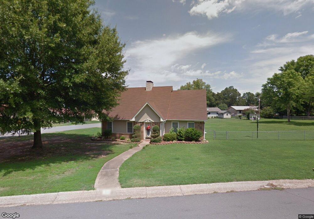
33 Bradley St Bryant, AR 72022
Estimated Value: $269,000 - $344,000
4
Beds
2
Baths
2,457
Sq Ft
$124/Sq Ft
Est. Value
About This Home
This home is located at 33 Bradley St, Bryant, AR 72022 and is currently estimated at $304,622, approximately $123 per square foot. 33 Bradley St is a home located in Saline County with nearby schools including Bryant Elementary School, Bryant Middle School, and Bethel Middle School.
Ownership History
Date
Name
Owned For
Owner Type
Purchase Details
Closed on
Jun 17, 2011
Sold by
Deutsche Bank National Trust Co
Bought by
Thompson Christopher M
Current Estimated Value
Home Financials for this Owner
Home Financials are based on the most recent Mortgage that was taken out on this home.
Original Mortgage
$152,239
Outstanding Balance
$109,929
Interest Rate
5.75%
Mortgage Type
FHA
Estimated Equity
$194,693
Purchase Details
Closed on
Mar 15, 2011
Bought by
Deutsche Bank/Ocwen Loan Serv
Purchase Details
Closed on
Aug 12, 2002
Bought by
Buck
Purchase Details
Closed on
Sep 4, 1996
Bought by
Pohle
Purchase Details
Closed on
Jul 11, 1994
Bought by
Henderson
Purchase Details
Closed on
Aug 25, 1993
Bought by
Sowle
Purchase Details
Closed on
Aug 1, 1992
Bought by
Hall
Create a Home Valuation Report for This Property
The Home Valuation Report is an in-depth analysis detailing your home's value as well as a comparison with similar homes in the area
Home Values in the Area
Average Home Value in this Area
Purchase History
| Date | Buyer | Sale Price | Title Company |
|---|---|---|---|
| Thompson Christopher M | $157,000 | -- | |
| Deutsche Bank/Ocwen Loan Serv | -- | -- | |
| Deutsche Bank/Ocwen Loan Serv | -- | -- | |
| Buck | $159,000 | -- | |
| Pohle | $109,000 | -- | |
| Henderson | $118,000 | -- | |
| Sowle | $110,000 | -- | |
| Hall | $101,000 | -- |
Source: Public Records
Mortgage History
| Date | Status | Borrower | Loan Amount |
|---|---|---|---|
| Open | Thompson Christopher M | $152,239 |
Source: Public Records
Tax History Compared to Growth
Tax History
| Year | Tax Paid | Tax Assessment Tax Assessment Total Assessment is a certain percentage of the fair market value that is determined by local assessors to be the total taxable value of land and additions on the property. | Land | Improvement |
|---|---|---|---|---|
| 2025 | $1,964 | $37,867 | $6,240 | $31,627 |
| 2024 | $1,791 | $37,867 | $6,240 | $31,627 |
| 2023 | $1,453 | $37,867 | $6,240 | $31,627 |
| 2022 | $1,374 | $37,867 | $6,240 | $31,627 |
| 2021 | $1,297 | $31,910 | $4,800 | $27,110 |
| 2020 | $1,297 | $31,910 | $4,800 | $27,110 |
| 2019 | $1,297 | $31,910 | $4,800 | $27,110 |
| 2018 | $1,322 | $31,910 | $4,800 | $27,110 |
| 2017 | $1,306 | $31,910 | $4,800 | $27,110 |
| 2016 | $1,469 | $30,100 | $4,800 | $25,300 |
| 2015 | $1,469 | $30,100 | $4,800 | $25,300 |
| 2014 | $1,119 | $30,100 | $4,800 | $25,300 |
Source: Public Records
Map
Nearby Homes
- lot 7 Kindness Ct
- 3.39 Acres N Reynolds Rd
- Lot 18 Ethel Dr
- 210 Dell Dr
- 2025 N Reynolds Rd
- 1810 Bishop Rd
- 511 Holly Lynn Dr
- 708 Pattywood Dr
- 1315 Helen Ct
- 86 Bame Cir Unit 1
- 23395 I-30 S
- 1311 Oscar Dr
- 1906 Pine Cir
- 600 Bristol Dr
- East 1/2 Tract 4 Market Place E
- 2918 Forest Dr
- West 1/2 Tract 4 Market Place E
- 2902 Andrew Dr
- 3512 Logan Ridge Dr
- 3516 Logan Ridge Dr