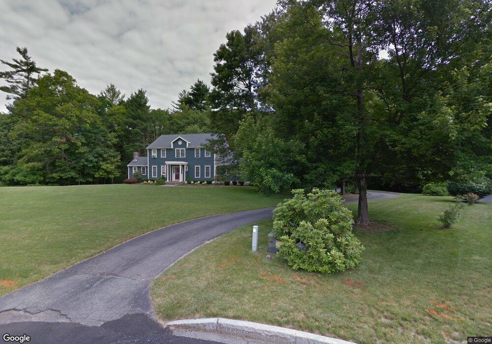
33 Briggs Ln Hanover, MA 02339
Estimated Value: $885,000 - $1,151,000
4
Beds
3
Baths
2,972
Sq Ft
$354/Sq Ft
Est. Value
About This Home
This home is located at 33 Briggs Ln, Hanover, MA 02339 and is currently estimated at $1,053,088, approximately $354 per square foot. 33 Briggs Ln is a home located in Plymouth County with nearby schools including Hanover High School.
Ownership History
Date
Name
Owned For
Owner Type
Purchase Details
Closed on
Sep 8, 2010
Sold by
Vickery Charles D and Dibartolomeo Dora A
Bought by
Raab Thomas R and Walsh-Raab Mary C
Current Estimated Value
Home Financials for this Owner
Home Financials are based on the most recent Mortgage that was taken out on this home.
Original Mortgage
$235,000
Outstanding Balance
$154,828
Interest Rate
4.55%
Mortgage Type
Purchase Money Mortgage
Estimated Equity
$898,260
Purchase Details
Closed on
Apr 15, 1988
Sold by
Briarwood Property
Bought by
Vickery Charles D
Create a Home Valuation Report for This Property
The Home Valuation Report is an in-depth analysis detailing your home's value as well as a comparison with similar homes in the area
Home Values in the Area
Average Home Value in this Area
Purchase History
| Date | Buyer | Sale Price | Title Company |
|---|---|---|---|
| Raab Thomas R | $535,000 | -- | |
| Vickery Charles D | $290,000 | -- |
Source: Public Records
Mortgage History
| Date | Status | Borrower | Loan Amount |
|---|---|---|---|
| Open | Raab Thomas R | $235,000 | |
| Previous Owner | Vickery Charles D | $100,000 | |
| Previous Owner | Vickery Charles D | $285,000 |
Source: Public Records
Tax History Compared to Growth
Tax History
| Year | Tax Paid | Tax Assessment Tax Assessment Total Assessment is a certain percentage of the fair market value that is determined by local assessors to be the total taxable value of land and additions on the property. | Land | Improvement |
|---|---|---|---|---|
| 2025 | $11,499 | $931,100 | $341,600 | $589,500 |
| 2024 | $10,679 | $831,700 | $341,600 | $490,100 |
| 2023 | $10,184 | $754,900 | $311,300 | $443,600 |
| 2022 | $9,946 | $652,200 | $260,400 | $391,800 |
| 2021 | $10,002 | $612,500 | $237,300 | $375,200 |
| 2020 | $9,717 | $595,800 | $237,300 | $358,500 |
| 2019 | $9,391 | $572,300 | $237,300 | $335,000 |
| 2018 | $8,772 | $538,800 | $237,300 | $301,500 |
| 2017 | $9,015 | $545,700 | $242,400 | $303,300 |
| 2016 | $8,720 | $517,200 | $220,800 | $296,400 |
| 2015 | $8,669 | $536,800 | $240,400 | $296,400 |
Source: Public Records
Map
Nearby Homes
- 13 Hayford Trail Unit 15
- 12 Hayford Trail Unit 17
- 5 Hayford Trail Unit 11
- 7 Hayford Trail Unit 12
- 22 Howland Trail Unit 34
- 154 Winter St
- 67 School St
- 21 King St
- 842 Whitman St
- 418 E Washington St
- 168 Spring St
- 55 Plymouth St Unit A5
- 248 E Washington St
- 696 Summer St
- 33 Tavern Way
- 14 Daniel Teague Dr
- 1057 Whitman St
- 41 Gail Rd
- 553 Center St
- Lot 5 Princeton Way