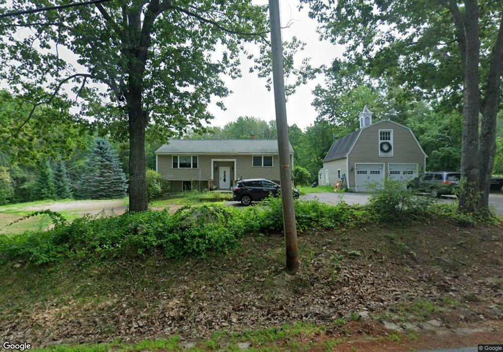
33 Bryant Rd Wolfeboro, NH 03894
Estimated Value: $393,000 - $518,000
About This Home
This home is located at 33 Bryant Rd, Wolfeboro, NH 03894 and is currently estimated at $435,166, approximately $266 per square foot. 33 Bryant Rd is a home located in Carroll County with nearby schools including Carpenter Elementary School, Crescent Lake School, and Kingswood Regional Middle School.
Ownership History
We collect this data history from publicly available records. To have your information removed, we recommend requesting removal directly through your county’s website.
Purchase Details
Home Values in the Area
Average Home Value in this Area
Purchase History
We collect this data history from publicly available records. To have your information removed, we recommend requesting removal directly through your county’s website.
| Date | Buyer | Sale Price | Title Company |
|---|---|---|---|
| $140,000 | -- | ||
| $140,000 | -- |
Mortgage History
We collect this data history from publicly available records. To have your information removed, we recommend requesting removal directly through your county’s website.
| Date | Status | Borrower | Loan Amount |
|---|---|---|---|
| Closed | $0 |
Tax History
We collect this data history from publicly available records. To have your information removed, we recommend requesting removal directly through your county’s website.
| Year | Tax Paid | Tax Assessment Tax Assessment Total Assessment is a certain percentage of the fair market value that is determined by local assessors to be the total taxable value of land and additions on the property. | Land | Improvement |
|---|---|---|---|---|
| 2025 | $3,588 | $429,200 | $138,500 | $290,700 |
| 2024 | $3,452 | $217,100 | $67,400 | $149,700 |
| 2023 | $3,189 | $217,100 | $67,400 | $149,700 |
| 2022 | $2,870 | $217,100 | $67,400 | $149,700 |
| 2021 | $2,968 | $217,100 | $67,400 | $149,700 |
| 2020 | $2,824 | $217,100 | $67,400 | $149,700 |
| 2019 | $2,764 | $174,500 | $58,000 | $116,500 |
| 2018 | $2,705 | $171,200 | $58,000 | $113,200 |
| 2017 | $2,565 | $171,200 | $58,000 | $113,200 |
| 2016 | $2,470 | $168,800 | $58,000 | $110,800 |
| 2015 | $2,355 | $168,800 | $58,000 | $110,800 |
| 2014 | $2,486 | $191,100 | $60,600 | $130,500 |
| 2013 | $2,452 | $191,100 | $60,600 | $130,500 |
Map
- 0 Camp Rd Unit 14
- 8 Wakefield North Rd
- Map 102 L 4 Center St
- 11 N Line Rd
- 1237 Center St
- Map 86 L 5 Haines Hill Rd
- 140 Holden Shore Rd
- 7 Shady Ln
- 6 Percy Dr
- 108 Whitten Neck Rd
- 8 Edwards Way
- 56 Kings Pine Rd
- 1 Harvey Brook Rd
- 00 Center St Unit 1
- 34 Village Corner Rd
- 156 Trotting Track Rd
- 76 Curries Way
- 33 Sky Ln
- 80 River St
- 28 Sky Ln
- 43 Bryant Rd
- 29 Bryant Rd
- 32 Bryant Rd
- 26 Bryant Rd
- 53 Bryant Rd
- 14 Bryant Rd
- 10 Wildwood Ln
- 10 Wildwood Ln
- 8 Wildwood Ln
- 9 Bryant Rd
- 9 Wildwood Ln
- 9 Ryefield Terrace
- 7 Ryefield Terrace
- 13 Ryefield Terrace
- 3 Ryefield Terrace
- 11 Ryefield Terrace
- 4 Bryant Rd
- 6 Wildwood Ln
- 546 Governor Wentworth Hwy
- 524 Governor Wentworth Hwy
Ask me questions while you tour the home.