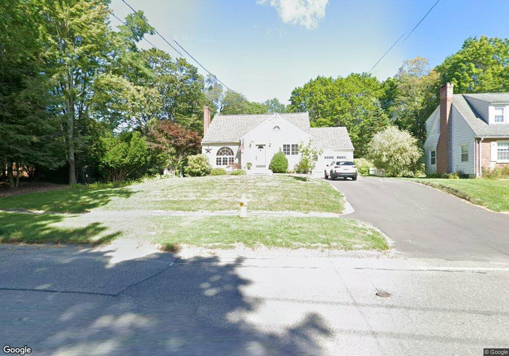
33 Elberon Ave Pittsfield, MA 01201
Estimated Value: $324,000 - $381,000
3
Beds
2
Baths
1,424
Sq Ft
$251/Sq Ft
Est. Value
About This Home
This home is located at 33 Elberon Ave, Pittsfield, MA 01201 and is currently estimated at $356,753, approximately $250 per square foot. 33 Elberon Ave is a home located in Berkshire County with nearby schools including Allendale Elementary School, Theodore Herberg Middle School, and Pittsfield High School.
Ownership History
Date
Name
Owned For
Owner Type
Purchase Details
Closed on
Apr 10, 2024
Sold by
Daoust Michael P and Decker-Daoust Maribeth
Bought by
Daoust Brendan and Daoust Bridget
Current Estimated Value
Purchase Details
Closed on
Feb 27, 1997
Sold by
Griffin Ronald F and Griffin Lynne E
Bought by
Daoust Michael and Deckerdaoust Maribeth
Create a Home Valuation Report for This Property
The Home Valuation Report is an in-depth analysis detailing your home's value as well as a comparison with similar homes in the area
Home Values in the Area
Average Home Value in this Area
Purchase History
| Date | Buyer | Sale Price | Title Company |
|---|---|---|---|
| Daoust Brendan | -- | None Available | |
| Daoust Brendan | -- | None Available | |
| Daoust Brendan | -- | None Available | |
| Daoust Michael | $115,000 | -- | |
| Daoust Michael | $115,000 | -- |
Source: Public Records
Mortgage History
| Date | Status | Borrower | Loan Amount |
|---|---|---|---|
| Previous Owner | Daoust Michael | $15,000 | |
| Previous Owner | Daoust Michael | $4,500 |
Source: Public Records
Tax History
| Year | Tax Paid | Tax Assessment Tax Assessment Total Assessment is a certain percentage of the fair market value that is determined by local assessors to be the total taxable value of land and additions on the property. | Land | Improvement |
|---|---|---|---|---|
| 2025 | $6,403 | $356,900 | $75,300 | $281,600 |
| 2024 | $5,810 | $314,900 | $75,300 | $239,600 |
| 2023 | $5,425 | $296,100 | $75,300 | $220,800 |
| 2022 | $4,870 | $262,400 | $70,300 | $192,100 |
| 2021 | $4,270 | $221,800 | $70,300 | $151,500 |
| 2020 | $4,013 | $203,600 | $57,300 | $146,300 |
| 2019 | $3,729 | $192,000 | $53,300 | $138,700 |
| 2018 | $3,736 | $186,700 | $53,300 | $133,400 |
| 2017 | $3,606 | $183,700 | $55,300 | $128,400 |
| 2016 | $3,525 | $187,900 | $55,300 | $132,600 |
| 2015 | $3,393 | $187,900 | $55,300 | $132,600 |
Source: Public Records
Map
Nearby Homes
- 36 Pittsfield Ave
- 167 E Park Terrace
- 21 Ensign Ave
- 0 Stanley Ave
- 81 Dartmouth St Unit 108
- 258 Dalton Ave
- 91 Dalton Ave
- 121 Elberon Ave
- 123 Broadview Terrace
- 40 Roland St
- 74 Norman Ave
- 326 Dalton Ave
- 96 Broadview Terrace
- 71 Dickinson Ave
- I11001904 Scammell Ave
- 0 Brown St
- 0 Parker St
- 48 Brown St
- 29 Glenwood Ave
- 56 Spring St
- 35 Elberon Ave
- 29 Elberon Ave
- 63 Delancy Ave
- 69 Delancy Ave
- 34 Elberon Ave
- 48 Pittsfield Ave
- 77 Delancy Ave
- 45 Delancy Ave
- 25 Elberon Ave
- 40 Pittsfield Ave
- 41 Delancy Ave
- 83 Delancy Ave
- 23 Elberon Ave
- 35 Delancy Ave
- 47 Elberon Ave
- 68 Delancy Ave
- 49 Pittsfield Ave
- 21 Elberon Ave
- 89 Delancy Ave
- 29 Delancy Ave
Your Personal Tour Guide
Ask me questions while you tour the home.