Estimated Value: $625,000 - $1,026,000
6
Beds
3
Baths
3,130
Sq Ft
$237/Sq Ft
Est. Value
About This Home
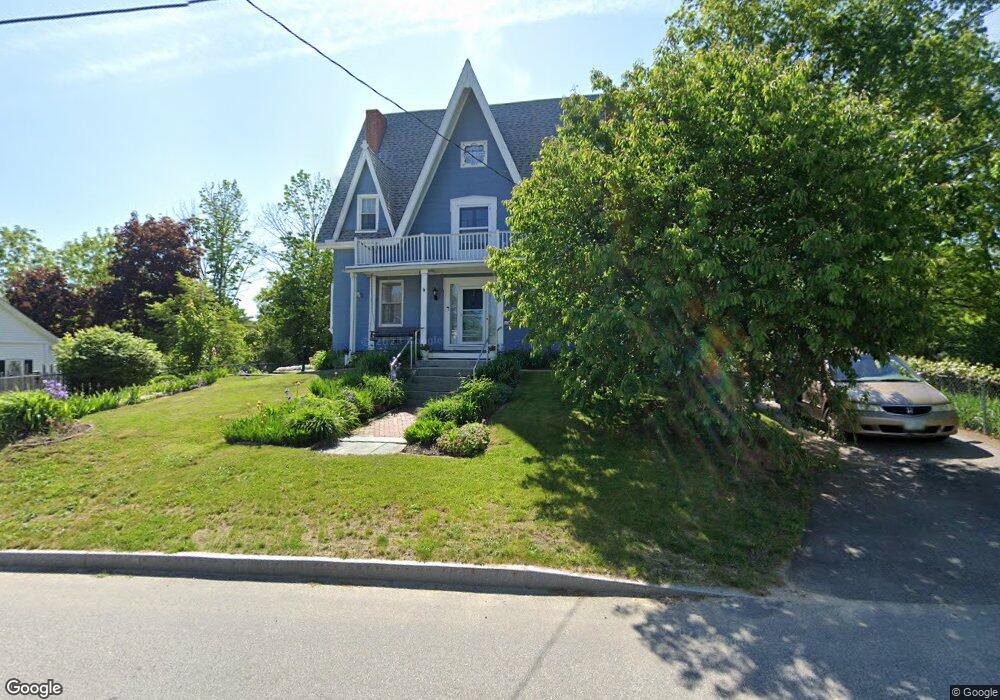
This home is located at 33 Hanson St, Dover, NH 03820 and is currently estimated at $742,958, approximately $237 per square foot. 33 Hanson St is a home located in Strafford County with nearby schools including Garrison School, Dover Middle School, and Dover Senior High School.
Ownership History
Date
Name
Owned For
Owner Type
Purchase Details
Closed on
Dec 18, 2024
Sold by
Small Elizabeth W
Bought by
Saffire Grantor T and Saffire Small
Current Estimated Value
Purchase Details
Closed on
Feb 16, 2000
Sold by
Lyons Alfred W and Lyons Trina R
Bought by
Small Gerald W and Small Elizabeth W
Home Financials for this Owner
Home Financials are based on the most recent Mortgage that was taken out on this home.
Original Mortgage
$94,500
Interest Rate
8.11%
Create a Home Valuation Report for This Property
The Home Valuation Report is an in-depth analysis detailing your home's value as well as a comparison with similar homes in the area
Home Values in the Area
Average Home Value in this Area
Purchase History
| Date | Buyer | Sale Price | Title Company |
|---|---|---|---|
| Saffire Grantor T | -- | None Available | |
| Saffire Grantor T | -- | None Available | |
| Small Gerald W | $179,900 | -- | |
| Small Gerald W | $179,900 | -- |
Source: Public Records
Mortgage History
| Date | Status | Borrower | Loan Amount |
|---|---|---|---|
| Previous Owner | Small Gerald W | $94,500 |
Source: Public Records
Tax History Compared to Growth
Tax History
| Year | Tax Paid | Tax Assessment Tax Assessment Total Assessment is a certain percentage of the fair market value that is determined by local assessors to be the total taxable value of land and additions on the property. | Land | Improvement |
|---|---|---|---|---|
| 2024 | $11,182 | $615,400 | $154,800 | $460,600 |
| 2023 | $9,606 | $513,700 | $147,000 | $366,700 |
| 2022 | $9,517 | $479,700 | $139,300 | $340,400 |
| 2021 | $9,214 | $424,600 | $116,100 | $308,500 |
| 2020 | $9,199 | $370,200 | $112,200 | $258,000 |
| 2019 | $8,592 | $341,100 | $100,600 | $240,500 |
| 2018 | $8,039 | $322,600 | $89,000 | $233,600 |
| 2017 | $7,368 | $284,800 | $69,600 | $215,200 |
| 2016 | $6,596 | $250,900 | $72,800 | $178,100 |
| 2015 | $6,083 | $228,600 | $64,700 | $163,900 |
| 2014 | $5,829 | $224,100 | $64,700 | $159,400 |
| 2011 | $5,348 | $212,900 | $65,300 | $147,600 |
Source: Public Records
Map
Nearby Homes
- 93 Henry Law Ave Unit 73
- 93 Henry Law Ave Unit 61
- 93 Henry Law Ave Unit 29
- 93 Henry Law Ave Unit Cricket Brook Condo
- 98 Henry Law Ave Unit 28
- 20-22 Kirkland St
- 4 Little Bay Dr
- 36 Little Bay Dr
- 22 Little Bay Dr
- 18 S Pine St
- 0 Hemlock Rd Unit 5059998
- 25 School St Unit 7
- 58 Saint Thomas St
- 79 Silver St
- 206 Locust St
- 98 Silver St
- 46-50 Cocheco St
- 32 Lenox Dr Unit D
- 7 Saint John St
- 3 Cocheco St
- 31 Hanson St
- 35 Hanson St
- 24 Hanson St
- 27 Hanson St
- 7 Hanson St
- 103 Cricketbrook
- 43 Cricketbrook Unit 43
- 98 Cricketbrook
- 73 Cricketbrook
- 63 Cricketbrook
- 107 Cricketbrook Unit 107
- 40 Cricketbrook
- 123 Cricketbrook Unit 123
- 53 Cricketbrook Unit 53
- 77 Cricketbrook
- 36 Cricketbrook
- 33 Cricketbrook Unit 33
- 48 Cricketbrook
- 61 Cricketbrook
- 144 Cricketbrook