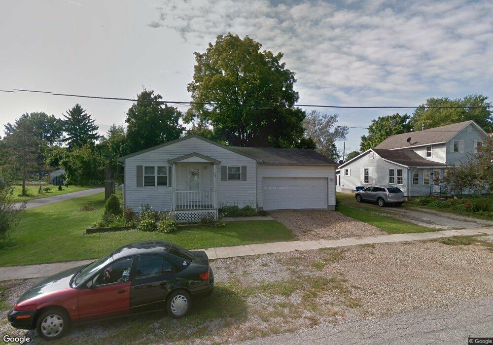
33 Pearl St Wakeman, OH 44889
Estimated Value: $160,000 - $211,000
1
Bed
2
Baths
1,040
Sq Ft
$183/Sq Ft
Est. Value
About This Home
This home is located at 33 Pearl St, Wakeman, OH 44889 and is currently estimated at $190,369, approximately $183 per square foot. 33 Pearl St is a home located in Huron County with nearby schools including Western Reserve Elementary School, Western Reserve Middle School, and Western Reserve High School.
Ownership History
Date
Name
Owned For
Owner Type
Purchase Details
Closed on
Nov 23, 2005
Bought by
Parker Gail L
Current Estimated Value
Purchase Details
Closed on
Jun 1, 2001
Sold by
Busek James W
Bought by
Gee Joseph A and Gee Sherry A
Purchase Details
Closed on
Nov 16, 1998
Sold by
Busek James W
Bought by
Feltis Linda L
Home Financials for this Owner
Home Financials are based on the most recent Mortgage that was taken out on this home.
Original Mortgage
$61,500
Interest Rate
6.68%
Mortgage Type
New Conventional
Purchase Details
Closed on
Oct 23, 1997
Sold by
Rahr Donald R
Bought by
Busek James W and Busek Charlynne
Purchase Details
Closed on
Jun 3, 1988
Bought by
Rahr Donald R
Create a Home Valuation Report for This Property
The Home Valuation Report is an in-depth analysis detailing your home's value as well as a comparison with similar homes in the area
Home Values in the Area
Average Home Value in this Area
Purchase History
| Date | Buyer | Sale Price | Title Company |
|---|---|---|---|
| Parker Gail L | $105,100 | -- | |
| Gee Joseph A | $96,000 | -- | |
| Feltis Linda L | $85,000 | -- | |
| Busek James W | $55,000 | -- | |
| Rahr Donald R | -- | -- |
Source: Public Records
Mortgage History
| Date | Status | Borrower | Loan Amount |
|---|---|---|---|
| Previous Owner | Feltis Linda L | $61,500 |
Source: Public Records
Tax History Compared to Growth
Tax History
| Year | Tax Paid | Tax Assessment Tax Assessment Total Assessment is a certain percentage of the fair market value that is determined by local assessors to be the total taxable value of land and additions on the property. | Land | Improvement |
|---|---|---|---|---|
| 2024 | $1,822 | $57,660 | $5,110 | $52,550 |
| 2023 | $1,822 | $46,420 | $3,610 | $42,810 |
| 2022 | $1,436 | $46,420 | $3,610 | $42,810 |
| 2021 | $1,479 | $46,420 | $3,610 | $42,810 |
| 2020 | $1,191 | $37,580 | $3,610 | $33,970 |
| 2019 | $1,547 | $37,580 | $3,610 | $33,970 |
| 2018 | $1,531 | $37,580 | $3,610 | $33,970 |
| 2017 | $1,433 | $35,500 | $3,610 | $31,890 |
| 2016 | $1,409 | $35,500 | $3,610 | $31,890 |
| 2015 | $1,396 | $35,510 | $3,610 | $31,900 |
| 2014 | $1,391 | $35,530 | $3,610 | $31,920 |
| 2013 | $1,346 | $35,530 | $3,610 | $31,920 |
Source: Public Records
Map
Nearby Homes
- 31 Depot St
- 22 E Main St
- 27 Deer Run Dr
- 6175 U S 20
- 5 Foxwood Cir
- 30 S River St
- 0 W Abbott Stony Brook Ln Unit 20253918
- 22 Foxwood Cir
- VL W Abbott Stony Brook Ln St
- 42 Stony Brook Ln
- 34 Cherdon Cir
- 5429 & 5431 St Rt 303
- 5810 U S 20 Unit 17
- 5810 U S 20 Unit 72
- 5810 U S 20 Unit 98
- 5810 U S 20 Unit 111
- 5810 U S 20 Unit 3
- 4718 Brushwood Rd
- 13701 Andress Rd
- 52025 Betts Rd