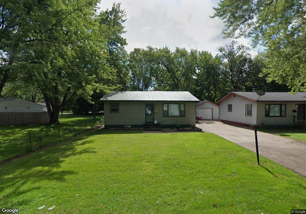
330 Bluff Ct Benton Harbor, MI 49022
Fair Plain NeighborhoodEstimated Value: $110,000 - $131,966
2
Beds
2
Baths
952
Sq Ft
$129/Sq Ft
Est. Value
About This Home
This home is located at 330 Bluff Ct, Benton Harbor, MI 49022 and is currently estimated at $122,492, approximately $128 per square foot. 330 Bluff Ct is a home located in Berrien County with nearby schools including Fair Plain Middle School, Benton Harbor High School, and Benton Harbor Charter School Academy.
Ownership History
Date
Name
Owned For
Owner Type
Purchase Details
Closed on
Nov 21, 2003
Sold by
Bridgewater Alvin P and Bridgewater Alice
Bought by
Bridgewater Alvin P and Bridgewater Alice
Current Estimated Value
Home Financials for this Owner
Home Financials are based on the most recent Mortgage that was taken out on this home.
Original Mortgage
$64,800
Outstanding Balance
$33,872
Interest Rate
7.87%
Mortgage Type
New Conventional
Estimated Equity
$88,620
Purchase Details
Closed on
Aug 25, 1995
Purchase Details
Closed on
Jul 22, 1992
Create a Home Valuation Report for This Property
The Home Valuation Report is an in-depth analysis detailing your home's value as well as a comparison with similar homes in the area
Home Values in the Area
Average Home Value in this Area
Purchase History
| Date | Buyer | Sale Price | Title Company |
|---|---|---|---|
| Bridgewater Alvin P | -- | Alpha Title Agency Inc | |
| -- | $40,300 | -- | |
| -- | $9,700 | -- |
Source: Public Records
Mortgage History
| Date | Status | Borrower | Loan Amount |
|---|---|---|---|
| Open | Bridgewater Alvin P | $64,800 |
Source: Public Records
Tax History Compared to Growth
Tax History
| Year | Tax Paid | Tax Assessment Tax Assessment Total Assessment is a certain percentage of the fair market value that is determined by local assessors to be the total taxable value of land and additions on the property. | Land | Improvement |
|---|---|---|---|---|
| 2025 | $920 | $46,900 | $0 | $0 |
| 2024 | $540 | $39,000 | $0 | $0 |
| 2023 | $515 | $33,400 | $0 | $0 |
| 2022 | $490 | $31,500 | $0 | $0 |
| 2021 | $801 | $33,100 | $7,400 | $25,700 |
| 2020 | $747 | $32,500 | $0 | $0 |
| 2019 | $713 | $26,800 | $3,500 | $23,300 |
| 2018 | $667 | $26,800 | $0 | $0 |
| 2017 | $658 | $26,200 | $0 | $0 |
| 2016 | $640 | $26,500 | $0 | $0 |
| 2015 | $638 | $24,700 | $0 | $0 |
| 2014 | $419 | $26,100 | $0 | $0 |
Source: Public Records
Map
Nearby Homes
- 202 Searles Ave
- 304 W May St
- 1000 Riverview Dr Unit 11
- 941 Colfax Ave
- 979 Lavette Ave
- 131 Clay St
- 171 E Empire Ave
- 694 Colfax Ave
- 1235 Colfax Ave
- 161 Kline Ave
- 576 Colfax Ave
- 1045 Broadway
- 398 Anchors Way Unit 82s
- 398 Anchors Way Unit 87s
- 972 Pearl St
- 180 Emery Ave
- 39884 Anchors Way
- 614 Pavone St
- 833 Pearl St
- 379 Western Ave